
Wayanad is a district in the north-east of Indian state Kerala with administrative headquarters at the municipality of Kalpetta. It is the only plateau in Kerala. The Wayanad Plateau forms a continuation of the Mysore Plateau, the southern portion of Deccan Plateau which links Western Ghats and Eastern Ghats. It is set high in the Western Ghats with altitudes ranging from 700 to 2100 meters. Vellari Mala, a 2,240 m (7,349 ft) high peak situated on the trijunction of Wayanad, Malappuram, and Kozhikode districts, is the highest point in Wayanad district. The district was formed on 1 November 1980 as the 12th district in Kerala, by carving out areas from Kozhikode and Kannur districts. An area of 885.92 km2 of the district is forested. Wayanad has three municipal towns—Kalpetta, Mananthavady and Sulthan Bathery. There are many indigenous tribes in this area. The Kabini River, a tributary of Kaveri River, originates at Wayanad. Wayanad district, along with the Chaliyar valley in neighbouring Nilambur in Malappuram district, is known for natural gold fields, which are also seen in other parts of the Nilgiri Biosphere Reserve. Chaliyar river, which is the fourth longest river of Kerala, originates on the Wayanad plateau. The historically important Edakkal Caves are located in Wayanad district.
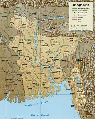
The Meghna River is one of the major rivers in Bangladesh, one of the three that form the Ganges Delta, the largest delta on earth, which fans out to the Bay of Bengal. A part of the Surma-Meghna River System, Meghna is formed inside Bangladesh in Kishoreganj District above the town of Bhairab Bazar by the joining of the Surma and the Kushiyara, both of which originate in the hilly regions of eastern India as the Barak River. The Meghna meets its major tributary, the Padma, in Chandpur District. Other major tributaries of the Meghna include the Dhaleshwari, the Gumti, and the Feni. The Meghna empties into the Bay of Bengal in Bhola District via four principal mouths, named Tetulia (Ilsha), Shahbazpur, Hatia, and Bamni.

Payyanur, IPA: [pɐjːɐn̺ːuːɾ], is a municipal town and a taluk, a sub-district administrative unit, in the Kannur district of Kerala, India. On 10 March 2018, Kerala Chief Minister Pinarayi Vijayan inaugurated Payyanur as the fifth taluk in the district. Payyanur taluk comprises 22 villages including 16 de-linked from the Taliparamba taluk and six from the Kannur taluk. The town is situated on the banks of the Perumba River.

Karamana is a river flowing through the city of Thiruvananthapuram in Kerala, India. The river starts near the southern tip of the Western Ghats(Sahyadri Mountains) at Agastyar Koodam. The river flows 66 km westward and merges with the Arabian Sea at Panathura near Kovalam. The river gets its name from Karamana, a suburb of Thiruvananthapuram city, through which it flows.

The Chandragiri River, also known as the Perumpuzha River, is the longest river in Kasaragod district, Kerala, India. It was named after the Mauryan emperor Chandragupta Maurya.

Malabar District, also known as Malayalam District, was an administrative district on the southwestern Malabar Coast of Bombay Presidency (1792-1800) and Madras Presidency (1800-1947) in British India, and independent India's Madras State (1947-1956). It was the most populous and the third-largest district in the erstwhile Madras State. The British district included the present-day districts of Kannur, Kozhikode, Wayanad, Malappuram, Palakkad, Chavakad Taluk and parts of Kodungallur Taluk of Thrissur district, and Fort Kochi area of Ernakulam district in the northern and central parts of present Kerala state, the Lakshadweep Islands, and a major portion of the Nilgiris district in Tamil Nadu. The detached settlements of Tangasseri and Anchuthengu, which were British colonies within the kingdom of Travancore in southern Kerala, also formed part of Malabar District until 1927. Malayalam was the administrative as well as the most spoken lingua franca of Malabar District during British Rule. Jeseri, a distinct dialect of Malayalam, was spoken in the Laccadive Islands. Malabar District merged with the erstwhile state of Travancore-Cochin (1950-1956) to form Kerala according to the States Reorganisation Act, 1956. On the same day, the present Kasaragod district of South Canara District was also attached to Malabar, and the Laccadive & Minicoy Islands of Malabar were reorganised to form a new Union Territory. Malabar was trifurcated to form the districts of Kannur, Kozhikode, and Palakkad, on 1 January 1957.
Kavvayi Backwaters located near Payyanur is the third largest backwater in Kerala and the largest one in north Kerala.

Mahé River is a river in South India. It flows through the state of Kerala and the coastal exclave of Mahé in Puducherry.

Thirumeni is a village in Kannur district in the Kerala state of India. It is known for its hill station Chathamangalam Hills. The village has several recently migrated families from various parts of the erstwhile political entity (state) of Travancore who settled here in the famed "Malabar migration period" in the nineteenth century. Most of the inhabitants of the village reside in the valley of three major hills by name Chathamangalam Theruvamala alias Alumbumala, Kottathalachimala and Thevarkunnumala. Thirumeni is a small junction with a few government institutions, religious institutions and small shops in int. and is subdivided into smaller villages like Kokkadave, Prapoyil, Chathamangalam (Kannur), Thabore, Muthuvom, Korali, Chattivayal, Thannichal, Paruthikallu etc.

Panamaram is a village in Wayanad district in the state of Kerala, India.

Odisha is one of the 28 states in the Republic of India. Odisha is located in the eastern part of the Indian peninsula and the Bay of Bengal lies to its East while Chhattisgarh shares its border in the west and north-west. The state also shares geographic boundaries with West Bengal in the north-east, Jharkhand in the north and Andhra Pradesh in the south. The state is spread over an area of 1,55,707 km2 and extends for 700 km from north to south and 500 kilometres from east to west. Its coastline is 450 km long. The state is divided into 30 districts which are further subdivided into 314 blocks.
There are places of worship considered important in the Kannur district. Kannur District is one of the 14 districts in the state of Kerala, India. The town of Kannur is the district headquarters, and gives the district its name.

Pilathara is a suburb town of Payyannur in the Kannur district of Kerala, India. This region is noted for its cultural, traditional and religious characteristics. The Government Medical College, Kannur aka Pariyaram Medical College is just 4 km away from Pilathara. Pazhayangadi and Mathamangalam are located south and north of Pilathara respectively. It comes under Payyanur taluk and Cheruthazham village. Kannur International Airport is the nearest airport of about 50 km away. The nearby railway station is at Pazhayangadi, just 8 km away from Pilathara town.
Kuttiady is one of the Major towns situated in the north-eastern part of Kozhikode district of Kerala, India. It is located 24 km (15 mi) from Vadakara and 50 km (31 mi) from Kozhikode. Kuttiady is situated in the slopes of the Western Ghats.
The Mogral River is a west-flowing river in the Kasaragod district in the Indian state of Kerala. It is named after Mogral, a coastal village on its northern banks. The river empties into the Arabian Sea at Mogral Puthur. It has a length of 34 kilometers and a drainage area of 132 square kilometers.

The Valapattanam River is a 110 km long river which flows through the Kannur district in North Kerala. It is the longest river in the Kannur district.

Olayambadi is a small village about 21 km from Payyanur town in the Kannur district of Kerala state, South India.
Neeleshwaram River originates from the western slopes of the Greater Talacauvery National Park in the Western Ghats, Karnataka. It is the second longest river in the Kasargod district after the Chandragiri River. The 56 km long Thejaswini River flows through the Kasargod district eventually emptying into the Kavvayi Backwaters.

The Anjarakandi River is one of two major rivers that flows through the Kannur District of Kerala in India. The river originates from the slopes of the Western Ghats bordering Wayanad and Kannur districts. The 48 km long river flows in the western direction emptying into the Arabian Sea at Dharmadom.
