Kannur is the sixth-most urbanised district in Kerala, with more than 50% of its residents living in urban areas. Kannur has an urban population of 1,640,986, which is the second largest in Kerala after Ernakulam district.[9][10] It was part of the Malabar District under the Madras province during the British Raj.
The kingdom of Ezhimala had jurisdiction over two Nadus - The coastal Poozhinadu and the hilly eastern Karkanadu. According to the works of Sangam literature, Poozhinadu consisted much of the coastal belt between Mangalore and Kozhikode.[12]Karkanadu consisted of Wayanad-Gudalur hilly region with parts of Kodagu (Coorg).[13] It is said that Nannan, the most renowned ruler of Ezhimala dynasty, took refuge at Wayanad hills in the 5th century CE when he was lost to Cheras, just before his execution in a battle, according to the Sangam works.[13]
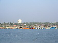
Kannur was an important trading center in the 12th century with active business connections with Persia and Arabia. The port at Kozhikode held the superior economic and political position in medieval Kerala coast, while Kannur, Kollam, and Kochi, were commercially important secondary ports, where the traders from various parts of the world would gather.[23] Kannur served as the British military headquarters on India's west coast until 1887. In conjunction with her sister city, Tellicherry, it was the third-largest city on the western coast of British India in the 18th century after Bombay and Karachi. The Arakkal kingdom had right over the city of Kannur and Laccadive Islands in the late medieval period.[24]
The Portuguese arrived at KappadKozhikode in 1498 during the Age of Discovery, thus opening a direct sea route from Europe to India.[25] The St. Angelo Fort at Kannur was built in 1505 by Dom Francisco de Almeida, the first Portuguese Viceroy of India. The Dutch captured the fort from the Portuguese in 1663. They modernized the fort and built the bastions Hollandia, Zeelandia, and Frieslandia that are the major features of the present structure. The original Portuguese fort was pulled down later. A painting of this fort and the fishing ferry behind it can be seen in the Rijksmuseum Amsterdam. The Dutch sold the fort to the king Ali Raja of Arakkal in 1772. The British conquered it in 1790 and used it as one of their major military stations on the Malabar Coast.
During the 17th century, Kannur was the capital city of the only Muslim polity in the Far-South of India – Arakkal – who also ruled the Laccadive Islands in addition to the city of Kannur.[26]Arakkal Kingdom and Chirakkal kingdom were two vassal kingdoms based in the city of Kannur. The island of Dharmadom near Kannur, along with Thalassery, was ceded to the East India Company as early as 1734, which were claimed by all of the Kolattu Rajas, Kottayam Rajas, Mannanar[27] and Arakkal Bibi in the late medieval period, where the British initiated a factory and English settlement following the cession.[28][21] In 1761, the British captured Mahé, and the settlement was handed over to the ruler of Kadathanadu.[29] The British restored Mahé to the French as a part of the 1763 Treaty of Paris.[29] In 1779, the Anglo-French war broke out, resulting in the French loss of Mahé.[29] In 1783, the British agreed to restore to the French their settlements in India, and Mahé was handed over to the French in 1785.[29]
Kannur district consists of two revenue subdivisions - Taliparamba and Thalassery.[35] For sake of rural administration, 71 Gram Panchayats are combined in 11 Blocks, which together form the Kannur District Panchayat.[36] For the sake of urban administration, Kannur Municipal Corporation and 9 municipal towns are there.[34]
For the representation of Kannur in Kerala Legislative Assembly, there are 11 assembly constituencies. These are included in three parliamentary constituencies, i.e., Kasaragod, Kannur, and Vatakara.[37] The district is further divided into 132 villages which together form 5 subdistricts.[38]
According to the 2018 Statistics Report, Kannur district has a population of 2,615,266,[3] The district has a population density of 882 inhabitants per square kilometre (2,280/sqmi).[40] Its population growth rate over the decade 2001–2011 was 4.84%.[40] The 2011 Census of India gives the district a ranking of 170th in India (out of a total of 640).[40] Kannur has a sex ratio of 1133 females for every 1000 males,[40] the highest among any district in India, and a literacy rate of 95.10%. Scheduled Castes and Scheduled Tribes make up 3.30% and 1.64% of the population respectively.[40]Malayalam is the predominant language, spoken by 98.88% of the population. Small minorities speak Tamil, Hindi and Kannada, mainly in urban areas.[41]
The District has a population of 2,412,365 (2001 census). This was the most urbanised district in Kerala in 2001, but was pushed to 4th place after Ernakulam, Thrissur and Kozhikode in 2011.[42] About 50.35% of the population reside in the urban agglomerations. The total urban population of Kannur district is 1,640,986. This is the second largest urban population in Kerala after Ernakulam and is more than the population of a metro city.[43]
Hinduism is the majority religion of Kannur district with 59.83% of the population. Muslims and Christians form a significant minority with 29.43% and 10.41% of the population respectively.[45]
Most of the Christians in Kannur district are descendants of Christians who migrated to Malabar in the 20th century.[46]
Kerala Folklore Academy, an autonomous centre for cultural affairs constituted by the Government of Kerala situated in Chirakkal, Kannur to promote and project the traditional art forms of Kerala.[47][48] The academy awards prizes and to notable artistes and experts in the field of folklore. The fellowships comprise ₹15000 each and citation. The folklore awards and book award carries ₹7500 and citation. The Gurupooja and Yuvaprathibha award winners will get ₹5000 each and citation.[49][50]
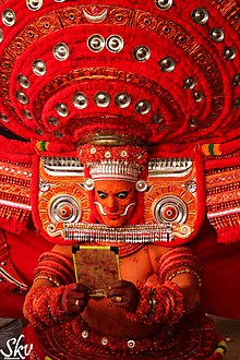
Theyyam of KeralaPuliyoor Kali Theyyam at Mathamangalam
Theyyam is a popular ritual form of dance worship inKannur-Kasaragod region of Kerala. Theyyam consisted of several thousand-year-old traditions, rituals, and customs. The performers of Theyyam belong to the lower caste community in ancient caste structure formed by Namboothiri Brahmins in Kerala, and have an important position in Theyyam.[51] It is performed mainly by males, except the Devakoothu theyyam. The Devakoothu is the only Theyyam ritual performed by women. It is performed only on the Thekkumbad Kulom temple.[52]
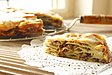
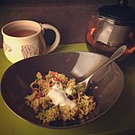
The Kannur cuisine depicts it culture and heritage. It is famous for Thalassery biriyani. The city of is also famous for Haluva called as Sweet Meat by Europeans due to the texture of the sweet. Another speciality is banana chips, which are made crisp and wafer-thin. Other popular dishes include seafood preparations (prawns, mussels, mackerel) . Vegetarian fare includes the sadya.
Kannur cuisine is a blend of traditional Kerala, Persian, Yemenese and Arab food culture.[55] This confluence of culinary cultures is best seen in the preparation of most dishes.[55]Kallummakkaya (mussels) curry, irachi puttu (irachi meaning meat), parottas (soft flatbread),[55]Pathiri (a type of rice pancake)[55] and ghee rice are some of the other specialties. The characteristic use of spices is the hallmark of the cuisine—black pepper, cardamom and clove are used profusely.
The Kerala version of biryani, popularly known as kuzhi mandi in Malayalam is another popular item, which has an influence from Yemen. Various varieties of biriyanis like Thalassery biriyani, and Kannur biriyani,[56] are prepared here.[55]
Kuttiattoor mango is popular and traditional cultivar of Kuttiattoor and neighbouring panchayats of Kannur district. Kuttiattoor mango received Geographical Indication (GI) tag from the GI registry at Chennai. The distinctiveness of Kuttiattoor mango is aided by the combination of specific environmental conditions of the area of its cultivation and varietal characters. Even though it is popularly known as Kuttiattoor mango, it is also known as ‘Nambiar mānga’, ‘Kannapuram mānga’, ‘Kunjimangalam mānga’ and ‘Vadakkumbhagam mānga’ in small pockets of Kannur district.[59][60]
↑ Ayinapalli, Aiyappan (1982). The Personality of Kerala. Department of Publications, University of Kerala. p.162. Retrieved 27 July 2018. A very powerful and warlike section of the Bants of Tulunad was known as Kola bari. It is reasonable to suggest that the Kola dynasty was part of the Kola lineages of Tulunad.
↑ Narayanan, M. G. S. Perumāḷs of Kerala. Thrissur (Kerala): CosmoBooks, 2013. 483.
↑ The Portuguese, Indian Ocean and European Bridgeheads 1500–1800. Festschrift in Honour of Prof. K. S. Mathew (2001). Edited by: Pius Malekandathil and T. Jamal Mohammed. Fundacoa Oriente. Institute for Research in Social Sciences and Humanities of MESHAR (Kerala)
↑ HENRY FROWDE, M.A., Imperial Gazetteer of India (1908–1909). Imperial Gazetteer of India (Newed.). Oxford: Clarendon Press. Retrieved 2 December 2020.
M. K. Devassy (1965), 1961 Census Handbook- Cannanore District(PDF), Directorate of Census Operations, Kerala and The Union Territory of Laccadive, Minicoy, and Amindivi Islands
This page is based on this Wikipedia article Text is available under the CC BY-SA 4.0 license; additional terms may apply. Images, videos and audio are available under their respective licenses.