Mangalpady

Last updated

Mangalpady
Panchayat
Olayam Masjidh, Kasargod, Kerala, India. (4804983754).jpg
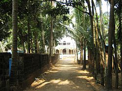
Olayam Masjidh, Shiriya
India Kerala location map.svg
Red pog.svg
Mangalpady
Location in Kerala, India
India location map.svg
Red pog.svg
Mangalpady
Mangalpady (India)
Coordinates: 12°38′35″N74°55′10″E / 12.64306°N 74.91944°E / 12.64306; 74.91944
CountryFlag of India.svg  India
State Kerala
District Kasaragod
Area
  Total36.3 km2 (14.0 sq mi)
Population
 (2011)
  Total48,441
  Density1,300/km2 (3,500/sq mi)
Languages
  Official Malayalam, English
Time zone UTC+5:30 (IST)
Vehicle registration KL-14

Mangalpady is a Grama Panchayat in Kasaragod district, Kerala. Uppala is the major town in this panchayat.

Contents

According to census 2011, it has a population of 48,441 in an area of 36.3 square km. With a population density of 1332.5 per square km, it is one of the densely populated panchayat in Kerala.

Villages in Mangalpady panchayat

Census towns in Mangalpady panchayat

Uppala Municipality Plan

If Uppala municipality is carved out from the Mangalpady and Manjeshwaram panchayat by adding the following to Uppala Census town:

Uppala Municipality will have a population of 66,431 in an area of 41.66 km2. The population density of the municipality will be around 1,600 per km2.[ citation needed ]

Demographics

As of 2011 India census, Mangalpady had a population of 48468. [1]

Languages

This locality is an essentially multi-lingual region. The people speak Malayalam, Tulu, Kannada, Urdu, Beary bashe and Konkani. Migrant workers also speak Hindi and Tamil languages.

Administration

This village is part of Manjeswaram assembly constituency which is again part of Kasaragod (Lok Sabha constituency)

Transportation

Local roads have access to National Highway No.66 which connects to Mangalore in the north and Trivandrum in the south. The nearest railway station is Uppala on Mangalore-Palakkad line. There is an airport at Mangalore.

Related Research Articles

<span class="mw-page-title-main">Manjeshwar</span> Town in Kerala, India

Manjeshwar is a town and a minor port in Kasaragod district at the northern tip of Kerala. It is situated at a distance of 584 kilometres (360 mi) from the state capital Thiruvananthapuram, 28 kilometres (20 mi) north of district HQ Kasaragod and 30 kilometres (20 mi) south of Mangalore city in neighbouring Karnataka. It is a coastal town in Kasaragod district.

Bangramanjeshwar (Bangramanjeshwaram) is a census town in Kasaragod district in the state of Kerala, India.

<span class="mw-page-title-main">Uppala</span> Town in Kerala, India

Uppala is a town and Headquarters of Manjeshwaram Taluk in Kasaragod district, Kerala, India. It is geographically located midway from Kasaragod to Mangalore. Easy geographical access and lack of major towns nearby are the key reasons for the town to develop exponentially, especially in the past decade. The population of Manjeshwaram Taluk alone was over 268,642 as of 2011. Uppala is 22 km north of Kasaragod and one of the fastest growing urban settlements in Kasaragod district. It is well known as an important trade hub in the northernmost part of Kerala state.

<span class="mw-page-title-main">Kasaragod district</span> District in Kerala, India

Kasaragod is one of the 14 districts in the southern Indian state of Kerala. Its northern border Thalappady is located just 9 km south to Ullal, which is the southernmost portion of the major port city Mangalore, on the southwestern Malabar coast of India.

<span class="mw-page-title-main">Badiyadka</span> Town in Kerala, India

Badiyadka officially known as "Badiadka" is a town and gram panchayat in the Kasaragod district, state of Kerala, India.

Bayar is a village in Kasaragod district in the state of Kerala, India. Bayar is 12 km (7.5 mi) far from the Uppala town.

<span class="mw-page-title-main">Paivalike</span> Village in Kerala, India

Paivalike is a village in Kasaragod district in the state of Kerala, India. Paivalike is 11 km (6.8 mi) east of Uppala town and 40 km (25 mi) south of Mangalore city.

<span class="mw-page-title-main">Vorkady</span> Gram Panchayat in Kerala, India

Vorkady is a Gram Panchayat in Kasaragod district in the state of Kerala, India.

Bekoor is a village near Uppala town in Kasaragod district in the state of Kerala, India. This locality is located in eastern Uppala, in Uppala-Bayar road, which connects Uppala with Paivalike, Bayar, and leads to Kanyana, Vittal and Puttur in dakshina Kannada district, Karnataka. It is around 3 km from Kaikamba junction and 1 km from Sonkal.

Katukukke is a village in Kasaragod district in the state of Kerala, India..The famous Shri Subraya Deva Temple present in this village so the village got the name Katukukke.

Kodibail is a village in Uppala town, Kasaragod district, Kerala, India. It is in the south west region of Uppala.

Kubanoor is a village near Uppala in Kasaragod district in the state of Kerala, India.

Meenja is a grama Panchayat in Manjeshwaram Taluk of Kasaragod district in the state of Kerala, India. It consists of 7 revenue villages. Kaliyoor, Koliyoor, Talakala, Meenja, Kadambar, Moodambail and [Kuloor]

Mulinja is a locality part of Uppala town, Kasaragod district, Kerala, India.

<span class="mw-page-title-main">Shiriya</span> Census Town in Kerala, India

Shiriya is a village in the Kasaragod district of Kerala, India. Shiriya is composed of several smaller villages, those being Shiriya, Shiriya kunnil, Muttam-gate, and Olayam.

Sajankila is a small village in Bayar Village in the Kasaragod district, state of Kerala, India.

<span class="mw-page-title-main">Manjeshwaram taluk</span> Taluk in Kerala, India

Manjeshwaram taluk is the northern most taluk of Kerala which borders Karnataka state. It is located in Kasaragod district, Kerala which was carved out from Kasaragod taluk on 2013.

<span class="mw-page-title-main">Perla, Kasaragod</span> Town in Kerala, India

Perla is an administrative capital of Enmakaje Panchayat, which is in Kasaragod district, Kerala, India.

Bedrampalla is a small town in Enmakaje Panchayat, Kerala, India. Bedrampalla is located on Seethangoli-Puthige-Perla road of about 4 km (2.5 mi) from Perla Town.

<span class="mw-page-title-main">Kasaragod North</span> Town in Kerala, India

Kasaragod North is a suburb of Kasaragod city in north Kerala. It is located at the mouth of a lagoon formed by the Shiriya river. The following townships, suburbs and villages are part of Kasaragod North:

References

  1. "Census of India : Villages with population 5000 & above". Registrar General & Census Commissioner, India. Archived from the original on 8 December 2008. Retrieved 10 December 2008.