This article needs additional citations for verification .(January 2017) |
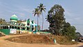
Bandiyod is a small town in the Kasaragod district of Kerala, India. It is located midway between Mangalore and Kasaragod.
Local roads have access to National Highway No.66 which connects to Mangalore in the north and Calicut in the south. The nearest railway station is Kumbla and Uppala on Mangalore-Palakkad line. There is an airport at Mangalore.
This locality is an essentially multi-lingual region. The people speak Malayalam, Tulu, Urdu, Beary, Kannada and Konkani. Migrant workers also speak Hindi and Tamil languages. This village is part of Manjeswaram assembly constituency which is again part of Kasaragod (Lok Sabha constituency).
Kasaragod is a municipal town and administrative headquarters of Kasaragod district in the state of Kerala, India. Established in 1966, Kasaragod was the first municipal town in the district. It is the northernmost district of Kerala and is also known as Sapta Bhasha Sangama Bhumi.
Kanhangad is a major town, located in the Kasaragod District, state of Kerala, India.
Dharmathadka is a small village in Kasaragod district of Kerala state, India.
Uppala is a town and Headquarters of Manjeshwaram Taluk in Kasaragod district, Kerala, India. It is geographically located midway from Kasaragod to Mangalore. Easy geographical access and lack of major towns nearby are the key reasons for the town to develop exponentially, especially in the past decade. The population of Manjeshwaram Taluk alone was over 268,642 as of 2011. Uppala is 22 km north of Kasaragod and one of the fastest growing urban settlements in Kasaragod district. It is well known as an important trade hub in the northernmost part of Kerala state.
Kasaragod is one of the 14 districts in the southern Indian state of Kerala. Its northern border Thalappady is located just 9 km south to Ullal, which is the southernmost portion of the major port city Mangalore, on the southwestern Malabar coast of India.
Karadka is a village, block panchayat and grama panchayat in Kasaragod district in the state of Kerala, India.
Karindalam is a village in Kasaragod district in the state of Kerala, India.
Kunjathur is a census town in Kasaragod district in the state of Kerala, India. It is 22 km (14 mi) south of Mangalore.
Mangalpady is a Grama Panchayat in Kasaragod district, Kerala. Uppala is the major town in this panchayat.
Paivalike is a village in Kasaragod district in the state of Kerala, India. Paivalike is 11 km (6.8 mi) east of Uppala town and 40 km (25 mi) south of Mangalore city.
Vorkady is a Gram Panchayat in Kasaragod district in the state of Kerala, India.
Heroor is a village in Kasaragod district in the state of Kerala, India.
Majibail is a village in Kasaragod district in the state of Kerala, India.
Meenja is a grama Panchayat in Manjeshwaram Taluk of Kasaragod district in the state of Kerala, India. It consists of 7 revenue villages. Kaliyoor, Koliyoor, Talakala, Meenja, Kadambar, Moodambail and [Kuloor]
Talikala is a village in Kasaragod district in the state of Kerala, India.
Mangalore Lok Sabha constituency was one of the Lok Sabha constituencies in Karnataka state in southern India. With the implementation of the delimitation of parliamentary constituencies in 2008, based on the recommendations of the Delimitation Commission of India constituted in 2002, this constituency ceased to exist.
Sajankila is a small village in Bayar Village in the Kasaragod district, state of Kerala, India.
Perla is an administrative capital of Enmakaje Panchayat, which is in Kasaragod district, Kerala, India.
Deenar Nagar is a small town in Kasaragod district, Kerala, India. Deenar Nagar is located about 3 km inwards to Bandiyod, a small town between Kasaragod and Mangalore. It is around 19.7 km north to the Kasaragod town and 39 km south to Mangalore.
South Kanara (South) Lok Sabha constituency was a former Lok Sabha constituency in Madras State. This seat came into existence in 1951. With the implementation of States Reorganisation Act, 1956, it ceased to exist.
12°38′24″N74°55′41″E / 12.640°N 74.928°E