Mayyil

Last updated

Mayyil
Velamvayanasala.jpg
Velam public library
India Kerala location map.svg
Red pog.svg
Mayyil
Location in Kerala, India
India location map.svg
Red pog.svg
Mayyil
Mayyil (India)
Coordinates: 12°02′N75°28′E / 12.04°N 75.46°E / 12.04; 75.46 Coordinates: 12°02′N75°28′E / 12.04°N 75.46°E / 12.04; 75.46
CountryFlag of India.svg  India
State Kerala
District Kannur
Taluk Taliparamba
Government
  Type Panchayati raj (India)
  BodyMayyil Grama Panchayat
Area
  Total33.08 km2 (12.77 sq mi)
Elevation
[1]
45 m (148 ft)
Population
 (2011) [2]
  Total29,649
  Density900/km2 (2,300/sq mi)
Languages
  Official Malayalam, English
Time zone UTC+5:30 (IST)
PIN
670602
ISO 3166 code IN-KL
Vehicle registration KL59
Nearest city Kannur
Assembly constituency Taliparamba
Lok Sabha constituency Kannur
Arimbra Subrahmanya Temple Arimbra Subrahmanya Temple, Mayyil Kannur.jpg
Arimbra Subrahmanya Temple
Perumacheri AUP School, Kolacherry, Mayyil Perumacheri AUP School.JPG
Perumacheri AUP School, Kolacherry, Mayyil
Padikkunnu Paadikkunu2.JPG
Padikkunnu

Mayyil is a Census Town and Grama Panchayat in Kannur District of Kerala State. Mayyil Panchayat established in 1962 by merging the villages of Kayaralam, Mayyil and Kandakkai. [3] [4]

Contents

Location

Mayyil is situated 20  km North East of District HQ Kannur, 13  km South East of Taliparamba, 20  km North West of Mattannur, 13  km South West of Sreekandapuram and 16  km West of Irikkur.

Educational institutions

Temples

Administration

Mayyil Panchayat is part of Irikkur Block Panchayat. Mayyil is politically a part of Taliparamba Assembly constituency under Kannur Loksabha constituency. [6]

Transportation

The national highway(NH 66) passes through Puthiyatheru (15 km South West), Dharmasala (11 km West), Taliparamba (13 km North West) away from Mayyil Town. Goa and Mumbai can be accessed on the northern side and Cochin and Thiruvananthapuram can be accessed on the southern side. The road to the east of Iritty connects to Mysore and Bangalore. The nearest railway station is Kannur on Mangalore-Palakkad line. Trains are available to almost all parts of India subject to advance booking over the internet. There are airports at Mattanur, Mangalore and Calicut. All of them are international airports but direct flights are available only to Middle Eastern countries. Newly inaugurated Kannur International Airport (Mattannur) is 22 km away from Mayyil, and the proposed 4 line airport road from Taliparamba to Mattannur passes through Mayyil.

Demographics

As of 2011 Indian census, Mayyil census town had population of 12,490 among which 5,768 are males and 6,722 are females. Total geographic area of mayyil census town is 12.77 km2 (4.93 sq mi). Population of age group in 0-6 was 1,557 (12.5%) which constitutes 771 males and 786 females. Literacy rate of Mayyil town was 92.7% lower than state average of 94% where male literacy was 96.2% while female literacy rate was 89.7%.

Mayyil Grama Panchayat had total population of 29,649 which constitutes 13,810 males and 15,839 with an area spreads over 33.1 km2 (12.8 sq mi) and 6,387 households. Mayyil panchayat has administration over Mayyil census town (urban) and Kayaralam village (rural). [7]

Religion

As of 2011 India census, Mayyil census town had total population of 12,490 which constitute 59.8% Hindus, 40% Muslims and 0.2% others. [8]

Geography

Mayyil is surrounded by around half of its boundary by Valapattanam river.

Libraries

Almost every road in this grama panchayat in Kerala's Kannur district leads to or ends with a library. The panchayat, which has a population of a little over 30,000 people in 33.08 km2 (12.77 sq mi) with a literacy rate of 93.52 percent, boasts 34 functioning libraries, the highest for a local body in Kerala state. [9] [10]

Related Research Articles

Padiyoor is a small town in Kannur district of Kerala state, India. Padiyoor village is part of Padiyoor-Kalliad Grama Panchayat in Iritty taluk.

<span class="mw-page-title-main">Mattanur</span> Municipality in Kerala, India

Mattanur, also spelled Mattannur, is a town, municipality, and an aerotropolis in Kannur district, Kerala, India. Mattanur is about 27 km east of Kannur and Thalassery, two major towns of the district.

<span class="mw-page-title-main">Irikkur</span> Census Town in Kerala, India

Irikkur is a town and grama panchayat in Kannur District of Kerala state, India.

<span class="mw-page-title-main">Peravoor</span> Town in Kerala, India

Peravoor is a town and Grama Panchayat in Kannur district of Kerala state in India. It is located 50 km (31 mi) east of Kannur and 40 km (25 mi) north east of Thalassery. And Iritty, the nearest municipality is 14 km (8.7 mi) north of Peravoor. Peravoor is situated in the Western Ghats mountain range.

<span class="mw-page-title-main">Ulikkal</span> Town in Kerala, India

Ulikkal is a growing town in Kannur District in Kerala. It is the HQ of Ulikkal Grama Panchayat in Iritty Taluk. Kerala State Hill highway SH 59 passes through Ulikkal Town.

Kannapurampronunciation  is a census town and grama panchayat in Kannur district of North Malabar region in the Indian state of Kerala.

<span class="mw-page-title-main">Mullakkodi</span> Village in Kerala, India

Mullakkodi is a village in Mayyil Gram Panchayat of Kannur District situated on the East Bank of Valapattanam river. Mullakkodi known for its backwaters, paddy fields and for its community festival called the Ayar Munamba Manna Maqam Urooz.

<span class="mw-page-title-main">Sreekandapuram</span> Municipality in Kerala, India

Sreekandapuram is a municipality in Kannur district, in the Indian state of Kerala.

Koodali is a census town and grama panchayat in Thalassery taluk of Kannur district in Kerala state, India. Koodali is located 15.5 km (9.6 mi) east of Kannur city on Kannur-Mattanur road.

<span class="mw-page-title-main">Pattuvam</span> Village in Kerala, India

Pattuvam is a village in Kannur district in the Indian state of Kerala. It is bordered by the Kuppam river on the north, west and south. It shares a border with Taliparamba municipality on the east. A bridge over the river connects Pattuvam to Kottakkeel of Ezhome village in the northwest.

<span class="mw-page-title-main">Koyyam</span> Village in Kerala, India

Koyyam is the part of Chengalai Panchayat, Kannur district, in the state of Kerala on the southwestern coast of India. Koyyam LP school is situated in "Koyyam". Koyyam Govt High School situated in Perinthaleri, Koyyam. The new bridge is constructing from koyyam to Velam, Mayyil. The transportation will be much easier to Kannur Town after completion Koyyam Bridge(23 km). The bridge will make koyyam is a very accessible place to the new Kannur International Airport, Mattannur. Main Airport Road will be passing through Koyyam from chempanthotti & Valakkai. This will be parallel rout for existing Parassinikkadavu from Taliparamba to Mattannur

<span class="mw-page-title-main">Alakode, Kannur district</span> Town in Kerala, India

Alakode is an emerging town in Kannur district in the Indian state of Kerala. It is located 46 km (29 mi) north of district headquarters Kannur. Alakode is located on Taliparamba-Manakadavu-Coorg Road. Alakode was one of the major centers of Malabar Migration.

Kuttiattoor is a census town in Taliparamba taluk of Kannur district in the Indian state of Kerala. Kuttiattoor is located 26 km (16 mi) north east of District headquarters Kannur and 6.5 km (4.0 mi) south east of Mayyil.

<span class="mw-page-title-main">Payyavoor</span> Town in Kerala, India

Payyavoor is a small town in Kannur district in the Indian state of Kerala. It's the headquarters of Payyavoor Grama Panchayat.

There are places of worship considered important in the Kannur district. Kannur District is one of the 14 districts in the state of Kerala, India. The town of Kannur is the district headquarters, and gives the district its name.

Mavichery is a village which is the part of Pariyaram Gramapanchayath in the Kannur district of Kerala, India.

<span class="mw-page-title-main">Aroli</span> Village in Kerala, India

Aroli is a village of Pappinisseri Panchayat in Kannur district in the Indian state of Kerala.

<span class="mw-page-title-main">Chapparapadavu</span> Village in Kerala, India

Chapparapadavu is a Grama panchayat in Kannur district in the Indian state of Kerala. Chapparapadavu Panchayat have administration over the villages of Kooveri, Thimiri and Vellad.

<span class="mw-page-title-main">Political divisions of Kannur district</span>

Kannur district is politically organized into a complex web of taluks, blocks, panchayaths and villages. In addition, there are also parliamentary divisions called Assembly constituencies and Lok Sabha constituencies.

<span class="mw-page-title-main">Taliparamba taluk</span> Taluka in Kerala, India

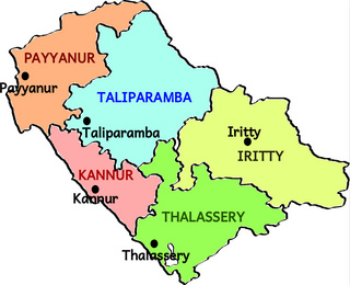
Taliparamba taluk is one of the five taluks in Kannur district in the state of Kerala, India. It borders Payyanur Taluk in the north, Kannur taluk and Thalassery taluk in the south and Iritty taluk in the east. It is a revenue division for the ease of administrative purposes, and is headquartered in Taliparamba. Most government offices are in the Mini Civil Station in Taliparamba. Taliparamba taluk consists of Taliparamba Municipality, Anthoor Municipality, Sreekandapuram Municipality and 15 surrounding panchayats.

References

  1. "Topographic map of Mayyil, Kannur, India".
  2. "കണ്ണൂര്‍ ജില്ലയിലെ ഗ്രാമ പഞ്ചായത്തുകളുടെ അടിസ്ഥാന വിവരങ്ങള്‍ | Deparyment of Panchayats".
  3. "Kerala (India): Districts, Cities and Towns - Population Statistics, Charts and Map".
  4. "DE Status".
  5. "Higher Education Institutes in Kannur University".
  6. "Assembly Constituencies - Corresponding Districts and Parliamentary Constituencies" (PDF). Kerala. Election Commission of India. Archived from the original (PDF) on 4 March 2009. Retrieved 18 October 2008.
  7. Kerala, Directorate of Census Operations. District Census Handbook, Kannur (PDF). Thiruvananthapuram: Directorateof Census Operations,Kerala. p. 180,181,278,279. Retrieved 14 July 2020.
  8. "Religion – Kerala, Districts and Sub-districts". Census of India 2011. Office of the Registrar General.
  9. "MAYYIL ..CM declares village in Kannur as nation's first with a fully digital library facility". www.ezhavainternational.com. Retrieved 15 September 2020.
  10. "This panchayat in Kerala has fifteen libraries". New Indian Express .