Ezhome

Last updated

Ezhome
Gov Welfare LP School Ezhome Moola.jpg
School at Ezhome Moola
India Kerala location map.svg
Red pog.svg
Ezhome
Location in Kerala, India
India location map.svg
Red pog.svg
Ezhome
Ezhome (India)
Coordinates: 12°2′0″N75°17′0″E / 12.03333°N 75.28333°E / 12.03333; 75.28333 Coordinates: 12°2′0″N75°17′0″E / 12.03333°N 75.28333°E / 12.03333; 75.28333
IndiaFlag of India.svg  India
State Kerala
District Kannur
Government
  Type Panchayati raj (India)
  BodyEzhome Grama Panchayat
Area
  Total18.9 km2 (7.3 sq mi)
Population
 (2011)
  Total19,261
  Density1,000/km2 (2,600/sq mi)
Languages
  Official Malayalam, English
Time zone UTC+05:30 (IST)
PIN
670334
ISO 3166 code IN-KL
Vehicle registration KL-86
Nearest city Pazhayangadi, Taliparamba, Payyanur, Kannur
Vidhan Sabha constituencyPayyanur
Mangroves in Ezhome Mangrove in Ezhome Moola (2).jpg
Mangroves in Ezhome
Ezhome Moola Ezhome Moola.jpg
Ezhome Moola

Ezhome is a census town in Kannur district in the Indian state of Kerala. [1]

Contents

Demographics

As of 2011 Census, Ezhome had a population of 19,261 which constitutes 8,716 (45.25%) males and 10,545 (54.75%) females. Ezhome census town spreads over an area of 18.9 km2 (7.3 sq mi) with 4,297 families residing in it. The male female sex ratio was 1,216 higher than state average of 1,084. In Ezhome, 11.2% population falls under 6 years age. Ezhome had overall literacy of 95.3% higher than state average of 94%. The male literacy stands at 98% and female literacy was 93.2%. [2]

Religion

As of 2011 Indian census, Ezhome census town had total population of 19,261 which constitutes 63.2% Hindus, 32.4% Muslims, 4% Christians and 0.4% others. [3]

Background

Pazhayangadi is the nearest railway station (2 km). The nearest airports are Kannur International Airport (CNN) which is 45 km south of Ezhome and Mangalore International Airport (IXE) which is 120 km north of Ezhome. On its western edge and mostly within the census town area is the village of Eripuram. [4]

Colleges include Madayi Cooperative Arts & Science College, Pariyaram Medical College, IHRD College Neruvampram, Payyanur College, Sir Syed College, Taliparamba, and Government College of Engineering, Kannur.

New Rice Varieties

Ezhome Rice varieties ‘Ezhome-1’ and ‘Ezhome-2’ are the first high yielding, non-lodging red rice varieties. They are designed for the saline-prone Kaipad rice fields of Kerala. They yield awn-less, non-shattering grains, and favourable cooking qualities, better than local cultivars. The average yields of ‘Ezhome-1’ and ‘Ezhome-2’ are 3.5 tones/ha and 3.2 tones/ha respectively under close-planted and no-management conditions of Kaipad. This yield is 70% and 60% more than that of local cultivars. These varieties differ in duration, have distinct morphological and qualitative traits, and have different salinity tolerance mechanisms, imparting varietal diversity to the unique ecosystem of Kaipad.

These new seed varieties have been developed by the Kerala Agricultural University with the participation of farmers of Ezhome panchayat. This is the first venture of Kerala Agricultural University in development of a variety i) adopting the combined strategy of Global Breeding (traditional), and Participatory Plant Breeding, and ii) carrying out all stages of variety development directly in the problem area of farmers. [5]

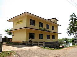
Uthraam Masjidh, Ettammel

Utharam Masjid, also known as Utharam Palli, is a famous mosque situated at Ettammel, an attractive place in Puthiyangadi of Kannur District. It is managed by the Puthiyangadi Muslim Jamath committee. This Mosque was built hundreds of years ago, and it was reconstructed about 60 years ago. This mosque is situated in Puthiyangadi "ettammel" near to the Jamaath high school.

Transportation

The national highway passes through Taliparamba town. Goa and Mumbai can be accessed on the northern side and Kochi and Thiruvananthapuram can be accessed on the southern side. The road to the east of Iritty connects to Mysore and Bangalore. The nearest railway station is Pazhayangadi on Mangalore-Palakkad line. Trains are available to almost all parts of India subject to advance booking over the internet. There are airports at Mangalore and Kannur. Both of them are international airports but direct flights are available only to Middle Eastern countries.

Villages

Related Research Articles

<span class="mw-page-title-main">Taliparamba</span> Municipality in Kerala, India

Taliparamba is a Municipality in Taliparamba taluk of Kannur district, Kerala, India. The municipal town spreads over an area of 18.96 square kilometres (7.32 sq mi) and is inhabited by 44,247 number of people.

Pariyaram is a Grama Panchayat consisting of two villages viz. Pariyaram census town and Kuttiyeri village. Pariyaram is a suburb of Taliparamba on National Highway between Taliparamba and Payyanur in Kerala state of India. Mini villages of Thiruvattoor, Koran Peedika, Mukkunnu & Chithappile Poyil are parts of Pariyaram.

<span class="mw-page-title-main">Ulikkal</span> Town in Kerala, India

Ulikkal is a growing town in Kannur District in Kerala. It is the HQ of Ulikkal Grama Panchayat in Iritty Taluk. Kerala State Hill highway SH 59 passes through Ulikkal Town.

<span class="mw-page-title-main">Matool</span> Village in Kerala, India

Matool is a village in Kannur district of Kerala State, India. Mattool is located 19 kilometres (12 mi) north of Kannur city. The Valapattanam River and Kuppam River meet the Arabian sea at Mattool. Mattool can be reached from Kannur via Azheekal crossing the Mattool - Azheekal ferry. And via Madakkara-Matool Bridge From Irinavu Road.

Kannapurampronunciation  is a census town and grama panchayat in Kannur district of North Malabar region in the Indian state of Kerala.

<span class="mw-page-title-main">Mayyil</span> Census Town in Kerala, India

Mayyil is a Census Town and Grama Panchayat in Kannur District of Kerala State. Mayyil Panchayat established in 1962 by merging the villages of Kayaralam, Mayyil and Kandakkai.

<span class="mw-page-title-main">Sreekandapuram</span> Municipality in Kerala, India

Sreekandapuram is a municipality in Kannur district, in the Indian state of Kerala.

<span class="mw-page-title-main">Naduvil and Kudianmala</span> Town in Kerala, India

Naduvil is a small town in Kannur district in the Indian State of Kerala. The town is the headquarters of Naduvil Grama panchayat.

<span class="mw-page-title-main">Pattuvam</span> Village in Kerala, India

Pattuvam is a village in Kannur district in the Indian state of Kerala. It is bordered by the Kuppam river on the north, west and south. It shares a border with Taliparamba municipality on the east. A bridge over the river connects Pattuvam to Kottakkeel of Ezhome village in the northwest.

<span class="mw-page-title-main">Alakode, Kannur district</span> Town in Kerala, India

Alakode is an emerging town in Kannur district in the Indian state of Kerala. It is located 46 km (29 mi) north of district headquarters Kannur. Alakode is located on Taliparamba-Manakadavu-Coorg Road. Alakode was one of the major centers of Malabar Migration.

<span class="mw-page-title-main">Cherukunnu</span> Census Town in Kerala, India

Cherukunnu is a census town in Kannur district in the Indian state of Kerala. Cherukunnu town is located on Valapattanam-Pappinisseri-Pazhayangadi main road, situated to the south of the Pazhayangadi in Kannur District of North Malabar region in Kerala.

<span class="mw-page-title-main">Kalliad</span> Village in Kerala, India

Kalliad is a village in Kannur district in the Indian state of Kerala.

<span class="mw-page-title-main">Kurumathur</span> Census Town in Kerala, India

Kurumathur is a census town in Taliparamba taluk of Kannur district in Kerala state, India. Kurumathur is located 8 km (5.0 mi) east of Taliparamba town in SH 36.

<span class="mw-page-title-main">Kuttiyeri</span> Village in Kerala, India

Kuttiyeri is a village of Pariyaram Grama Panchayath near Taliparamba town in Kannur district in the Indian state of Kerala. Mini villages of Vellavu, Mavichery, Thalora & Panangattoor are parts of Kuttiyeri.

Nediyanga is a village comes under Sreekandapuram Municipality in Kannur district in the Indian state of Kerala.

Panniyoor is a village in Kannur district in the Indian state of Kerala.

Pattannur is a village in Kannur district in the Indian state of Kerala. It is 4 km away from Irikkur and 7 km away from Mattanur.

Eruvessi is a village in Irikkur Block Panchayat, Taliparamba Taluk, Kannur district in Kerala, India. It is located at a distance of around 50 Kilometers from Kannur. There is a famous temple called Padikkutti Devi temple and the festival or Utsav is well known. Eruvessi Sri Padikutty temple is the birthplace of Sree Muthappan. This place was ruled by Mannanar dynasty of Muthedath Aramana and Elayadath Aramana. The ruins of Aramana of the Mananar are still visible on the banks of Eruvessi River.

<span class="mw-page-title-main">Eripuram</span>

Eripuram is a village within the Payyanur Taluk of Kannur district in the state of Kerala, India.

Kolachery is a census town and Grama Panchayat in Kannur District of Kerala state, India. Kolachery is located 15 kilometres (9.3 mi) north east of Kannur city.

References

  1. "Census of India: Villages with population 5000 & above". Registrar General & Census Commissioner, India. Archived from the original on 8 December 2008. Retrieved 10 December 2008.{{cite web}}: CS1 maint: others (link)
  2. Kerala, Directorate of Census Operations. District Census Handbook, Kannur (PDF). Thiruvananthapuram: Directorateof Census Operations,Kerala. p. 186,187. Retrieved 14 July 2020.
  3. "Religion – Kerala, Districts and Sub-districts". Census of India 2011. Office of the Registrar General.
  4. "Ezhome, Kerala, India". Google Maps. Google, Inc. Retrieved 25 April 2022.
  5. "Crops cleared for farming". The Hindu . Chennai, India. 19 January 2010. Archived from the original on 24 January 2010.