Kottayam-Malabar

Last updated

Kottayam-Malabar
India Kerala location map.svg
Red pog.svg
Kottayam-Malabar
Location in Kerala, India
India location map.svg
Red pog.svg
Kottayam-Malabar
Kottayam-Malabar (India)
Coordinates: 11°49′37″N75°32′58″E / 11.8269°N 75.5495°E / 11.8269; 75.5495 Coordinates: 11°49′37″N75°32′58″E / 11.8269°N 75.5495°E / 11.8269; 75.5495
CountryFlag of India.svg  India
State Kerala
District Kannur
Area
  Total8.43 km2 (3.25 sq mi)
Population
 (2011)
  Total19,176
  Density2,300/km2 (5,900/sq mi)
Languages
  Official Malayalam, English
Time zone UTC+5:30 (IST)
PIN
670643
Telephone code0490
ISO 3166 code IN-KL
Vehicle registration KL-58
Nearest cityThalassery
Sex ratio 1000:1176 /
Lok Sabha constituencyVatakara
Vidhan Sabha constituencyKuthuparamba

Kottayam-Malabar is a census town near Kuthuparamba in Kannur district of Kerala state in India. It is different from the city of Kottayam in Kottayam district of the same state. [1]

Contents

History

Kingdom of Kottayam is a historic province of old Malabar district in India. It covered what is today Talassery Taluk of Kannur district. The headquarters of the kingdom was at Kottayam-Malabar town. The Raja of Kottayam presided over the province. Pazhassi Raja was a member of the western branch of the Kottayam royal clan. When Hyder Ali of the Kingdom of Mysore occupied Malabar in 1773, the Raja of Kottayam found political asylum in Kallara near Vikom in Kottayam district of Kerala. Pazhassi Raja, the fourth prince in line for succession to the throne during this period, became one of the de facto heads of state, surpassing several older royal contenders. [2] [3]

Demographics

As of 2011 Census, Kottayam-Malabar census town had population of 19,176 which constitutes 8,813 males and 10,363 females. Kottayam-Malabar census town spreads over an area of 8.43 square kilometres (3.25 sq mi) with 3,815 families residing in it. The sex ratio was 1176 higher than state average of 1084. Population of children in the age group 0-6 was 2,302 (12%) where 1,141 are males and 1,161 are females. Kottayam-Malabar had an overall literacy of 96.2% higher than state average of 94%. The male literacy stands at 97.7% and female literacy was 95%. [4]

Transportation

The national highway passes through Thalassery town. Mangalore, Goa and Mumbai can be accessed on the northern side and Kochi and Thiruvananthapuram can be accessed on the southern side. The road to the east of Iritty connects to Mysore and Bangalore. The nearest railway station is Thalassery on Mangalore-Palakkad line. Trains are available to almost all parts of India subject to advance booking over the internet. There are airports at Mangalore and Kozhikode. Both of them are international airports but direct flights are available only to Middle Eastern countries.

See also

Related Research Articles

<span class="mw-page-title-main">Kannur</span> Metropolis in Kerala, India

Kannur, formerly known in English as Cannanore, is a city and a municipal corporation in the state of Kerala, India. It is the administrative headquarters of the Kannur district and situated 274 kilometres (170 mi) north of the major port city and commercial hub Kochi and 137 kilometres (85 mi) south of the major port city and a commercial hub, Mangalore. During the period of British colonial rule in India, when Kannur was a part of the Malabar District, the city was known as Cannanore. Kannur is the sixth largest urban agglomeration in Kerala. As of 2011 census, Kannur Municipal Corporation, the local body which administers mainland area of city, had a population of 232,486.

<span class="mw-page-title-main">Mattanur</span> Municipality in Kerala, India

Mattanur, also spelled Mattannur, is a town, municipality, and an aerotropolis in Kannur district, Kerala, India. Mattanur is about 27 km east of Kannur and Thalassery, two major towns of the district.

<span class="mw-page-title-main">Kuthuparamba</span> Municipality in Kerala, India

Kuthuparamba is a town and a municipality in the Kannur district, state of Kerala, India. It is about 24 km south east of Kannur and 14 km east of Thalassery.

<span class="mw-page-title-main">Irikkur</span> Census Town in Kerala, India

Irikkur is a town and grama panchayat in Kannur District of Kerala state, India.

<span class="mw-page-title-main">Peravoor</span> Town in Kerala, India

Peravoor is a small town and Grama Panchayat in Kannur district of Kerala state in India. It is located 50 km (31 mi) east of Kannur and 40 km (25 mi) north east of Thalassery. And Iritty, the nearest municipality is 14 km (8.7 mi) north of Peravoor. Peravoor is situated in the Western Ghats mountain range.

Eranholi is a census town and suburb of Thalassery in Tellicherry Municipality in the state of Kerala, India, and located on Tellichery Mysore highway. The nearest town is Chirakkara. Eranholi bridge built across Eranholi river in 1937 which is entry to Tellicherry.The Eranholi Bridge is a significant bridge of TC Road.

<span class="mw-page-title-main">Dharmadom</span> Census Town in Kerala, India

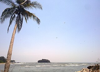
Dharmadom or Dharmadam is a census town in Thalassery taluk of Kannur district in the state of Kerala, India. This town is located in between Anjarakandi River and Ummanchira river, and Palayad town and Arabian sea. It is known for the 100-year-old Government Brennen College and Dharmadam Island.

Mavilayi is a census town in Kannur district in the Indian state of Kerala. Situated in Peralasseri Panchayath on Kannur-Kuthuparamba State Highway, 15 km away from Kannur Town.

<span class="mw-page-title-main">New Mahe</span> Village in Kerala, India

New Mahe is a census town in Thalassery taluk of Kannur district in the Indian state of Kerala. It is part of Greater Mahé Region.

<span class="mw-page-title-main">Panniyannur</span> Census Town in Kerala, India

Panniyannur is a census town in Thalassery taluk of Kannur district in the Indian state of Kerala. It is part of Greater Mahé Region.

Pathiriyad is a census town in Kannur district in the Indian state of Kerala.

Pattiam is a census town in Kannur district in the Indian state of Kerala.

Peringathur is a census town in Thalassery taluk of Kannur district in the Indian state of Kerala. It is a part of Panoor municipality.

Mangattidam is a census town and a panchayat situated near Kuthuparamba in Thalassery taluk, Kannur district, Kerala, India.

<span class="mw-page-title-main">Anjarakkandy</span> Census Town in Kerala, India

Anjarakandy is a census town and grama panchayat in Kannur district of Kerala, India. Anjarakandy river is flowing through Anjarakandy town.

Cheruvanchery is a village in Kannur district in the Indian state of Kerala. A detailed history of the town for the first time was written in a blog "Cheruvanchery: A Tale of Erased Times".

<span class="mw-page-title-main">Kannavam</span> Village in Kerala, India

Kannavam is a Village in Thalassery Taluk in Kannur District of Kerala State, India. It comes under Chittaripparamba Panchayat. It is located 37 km (23 mi) south east of District headquarters Kannur, 13 km (8.1 mi) east of Kuthuparamba and 466 km (290 mi) from State capital Thiruvananthapuram

Manantheri is a census town near Kuthuparamba in Kannur district in the Indian state of Kerala.

<span class="mw-page-title-main">Manathana</span> Village in Kerala, India

Manathana is a village in Peravoor Grama Panchayat of Kannur district, Kerala, India.

Mokeri is a Census Town in Mokeri panchayat of Kannur district in the Indian state of Kerala.

References

  1. "Census of India 2001: Data from the 2001 Census, including cities, villages and towns (Provisional)". Census Commission of India. Archived from the original on 16 June 2004. Retrieved 1 November 2008.
  2. William Logan (2000). Malabar Manual. Asian Educational Services. pp. 1–. ISBN   978-81-206-0446-9.
  3. Menon, A. Sreedhara (2006). A Survey of Kerala History. S. Viswanathan. p. 172. ISBN   978-81-87156-01-7.
  4. Kerala, Directorate of Census Operations. District Census Handbook, Kannur (PDF). Thiruvananthapuram: Directorateof Census Operations,Kerala. p. 204,205. Retrieved 14 July 2020.