Kooveri Koovery | |
|---|---|
village | |
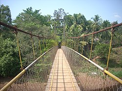 Kooveri Suspension Bridge | |
 Kooveri Location in Kerala, India | |
| Coordinates: 12°06′34″N75°23′39″E / 12.10938°N 75.39413°E | |
| Country | |
| State | Kerala |
| District | Kannur |
| Government | |
| • Body | Chapparapadavu Grama Panchayat |
| Area | |
• Total | 38.32 km2 (14.80 sq mi) |
| Population (2011) | |
• Total | 19,033 |
| • Density | 500/km2 (1,300/sq mi) |
| Languages | |
| • Official | Malayalam, English |
| Time zone | UTC+5:30 (IST) |
| PIN | 670581 |
| Vehicle registration | KL 59 |
| Nearest city | Taliparamba |
| Lok Sabha constituency | Kannur |
| Vidhan Sabha constituency | Taliparamba |
Kooveri is a village in Chapparapadavu Grama Panchayat of Kannur district in the Indian state of Kerala. [1]