Cheruthazham

Last updated

Cheruthazham
Cheruthazham sree kunninmathilakam mahadeva temple.jpg
Kunhimathilakam Temple
India Kerala location map.svg
Red pog.svg
Cheruthazham
Location in Kerala, India
India location map.svg
Red pog.svg
Cheruthazham
Cheruthazham (India)
Coordinates: 12°04′51″N75°15′46″E / 12.0809700°N 75.2627200°E / 12.0809700; 75.2627200 Coordinates: 12°04′51″N75°15′46″E / 12.0809700°N 75.2627200°E / 12.0809700; 75.2627200
CountryFlag of India.svg  India
State Kerala
District Kannur
Government
  Type Panchayati raj (India)
Area
  Total20.9 km2 (8.1 sq mi)
Population
 (2011)
  Total29,348
  Density1,400/km2 (3,600/sq mi)
Languages
  Official Malayalam, English
Time zone UTC+5:30 (IST)
PIN
670501
ISO 3166 code IN-KL
Vehicle registration KL-86

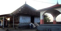
Cheruthazham is a Census Town and Grama Panchayat in Kannur district in the state of Kerala, India. [1] It is the location of the famous Hanumarambalam, dedicated to Sri Rama and Hanuman.Cherutazham is also the birthplace of Kalamandalam Krishnan Nair who gave a new dimension to the art of Kathakali. There are many artists in Cherutazham who are experts in the traditional musical items like "panchavadyam", "taayambaka", "chenda melam" etc. The new generation of Cherutazham is also getting trained in these art forms.

Contents

Demographics

As of 2011 Census, Cheruthazham had a population of 29,348 of which 13,571 are males and 15,777 are females. Cheruthazham census town spreads over an area of 32.17 km2 with 7,074 families residing in it. The male female sex ratio was 1,162 higher than state average of 1,084. 10.3% of the total population falls under 6 years age. Cheruthazham census town had overall literacy of 95%, higher than national average of 59% and higher than state average of 94%. The male literacy stands at 97.7% and female literacy was 92.7%. [2]

Religion

As of 2011 Indian census, Cheruthazham census town had total population of 29,348 which constitutes 76.5% Hindus, 13.5% Muslims, 9.8% Christians and 0.2% others. [3]

Transportation

The national highway passes through Pilathara junction. Goa and Mumbai can be accessed on the northern side and Cochin and Thiruvananthapuram can be accessed on the southern side. The road to the east of Iritty connects to Mysore and Bangalore. The nearest railway station is Payyanur on Mangalore-Palakkad line. Trains are available to almost all parts of India subject to advance booking over the internet. There are airports at Kannur, Mangalore and Calicut. All of them are international airports but direct flights are available only to Middle Eastern countries.

Related Research Articles

Kadirur Census Town in Kerala, India

Kadirur is a census town within the Thalassery Taluk of Kannur District in the State of Kerala, India. Kadirur is located about 8 km (5.0 mi) from the Thalassery Township on the Tellicherry-Mysore road.

Eranholi Census Town in Kerala, India

Eranholi is a census town near Thalassery in Kannur district in the state of Kerala, India, and located on Tellichery Mysore highway. The nearest town is Thalassery. Eranholi bridge built across Eranholi river in 1937 connect Eranholi with Tellicherry.

Iriveri Census Town in Kerala, India

Iriveri is a census town in Kannur district in the Indian state of Kerala.

Kannadiparamba Census Town in Kerala, India

Kannadiparamba is a census town in Kannur district in the Indian state of Kerala.

Kottayam-Malabar Village in Kerala, India

Kottayam-Malabar is a census town near Kuthuparamba in Kannur district of Kerala state in India. It is different from the city of Kottayam in Kottayam district of the same state.

Mavilayi Census Town in Kerala, India

Mavilayi is a census town in Kannur district in the Indian state of Kerala. Situated in Peralasseri Panchayath on Kannur-Kuthuparamba State Highway, 15 km away from Kannur Town.

Narath Census Town in Kerala, India

Narath is a census town in Kannur district in the Indian state of Kerala.

Paduvilayi Census Town in Kerala, India

Paduvilayi is a census town in Kannur district in the Indian state of Kerala.

Panniyannur Census Town in Kerala, India

Panniyannur is a census town in Thalassery taluk of Kannur district in the Indian state of Kerala. It is part of Greater Mahé Region.

Pathiriyad Census Town in Kerala, India

Pathiriyad is a census town in Kannur district in the Indian state of Kerala.

Pattiom Census Town in Kerala, India

Pattiam is a census town in Kannur district in the Indian state of Kerala.

Peringathur Census Town in Kerala, India

Peringathur is a census town in Thalassery taluk of Kannur district in the Indian state of Kerala. It is a part of Panoor municipality.

Mangattidam Census Town in Kerala, India

Mangattidam is a census town and a panchayat situated near Kuthuparamba in Thalassery taluk, Kannur district, Kerala, India.

Cheleri Census Town in Kerala, India

Cheleri is a census town in Kannur district in the Indian state of Kerala.

Cheruvanchery village in Kerala, India

Cheruvanchery is a village in Kannur district in the Indian state of Kerala. A detailed history of the town for the first time was written in a blog "Cheruvanchery: A Tale of Erased Times".

Ezhome Census Town in Kerala, India

Ezhome is a census town in Kannur district in the Indian state of Kerala.

Kandamkunnu Census Town in Kerala, India

Kandamkunnu is a census town in Kannur district in the Indian state of Kerala.

Malapattam village in Kerala, India

Malapattam is a village in Kannur district in the Indian state of Kerala.

Mokeri Census Town in Kerala, India

Mokeri is a Census Town in Mokeri panchayat of Kannur district in the Indian state of Kerala.

Sivapuram, Kerala Village in Kerala, India

Sivapuram is a village in Kannur district in the Indian state of Kerala.

References

  1. "Census of India 2001: Data from the 2001 Census, including cities, villages and towns (Provisional)". Census Commission of India. Archived from the original on 16 June 2004. Retrieved 1 November 2008.
  2. Kerala, Directorate of Census Operations. District Census Handbook, Kannur (PDF). Thiruvananthapuram: Directorateof Census Operations,Kerala. p. 186,187. Retrieved 14 July 2020.
  3. "Religion – Kerala, Districts and Sub-districts". Census of India 2011. Office of the Registrar General.