
Malappuram, is one of the 14 districts in the Indian state of Kerala, with a coastline of 70 km (43 mi). The most populous district of Kerala, Malappuram is home to around 13% of the total population of the state. The district was formed on 16 June 1969, spanning an area of about 3,554 km2 (1,372 sq mi). It is the third-largest district of Kerala by area. It is bounded by Western Ghats and the Arabian Sea on either side. The district is divided into seven Taluks: Eranad, Kondotty, Nilambur, Perinthalmanna, Ponnani, Tirur, and Tirurangadi.

Chemmad is a town and a commercial hub of Tirurangadi ,which is situated in Malappuram district of Kerala state, India. Administrative headquarters of Tirurangadi Taluk, is a fast-growing town in Malappuram district, Kerala, India. Darul Huda Islamic University the first Private and Islamic university in the Malabar region, is located north-west part DHU area.

Tirur is a major municipal town in Tirur Taluk, Malappuram district, in the Indian state of Kerala, spread over an area of 16.55 square kilometres (6.39 sq mi).

Pocker Sahib Memorial Orphanage College (PSMO) is a government-aided private junior college affiliated to the University of Calicut. It was established in 1968 under the management of the Tirurangadi Muslim Orphanage.
Feroke is a Municipality and a part of Kozhikode metropolitan area under Kozhikode Development Authority (K.D.A) in the Kozhikode district of the Indian state of Kerala.

Tanur is a coastal town, a municipality, and a block located in Tirur Taluk, Malappuram district, Kerala, India. It is located on the Malabar Coast, 9 kilometres (5.6 mi) north of Tirur and 9 kilometres south of Parappanangadi. It is the 17th-most populated municipality in the state, the fourth-most populated municipality in the district, and the second-most densely populated municipality in Malappuram district, having about 3,568 residents per square kilometre as of the year 2011.

Ramanattukara is a municipality census town in Kozhikode district in the Indian state of Kerala. The town was formerly called Kadungan Chira village. Ramanattukara is located 15 km away from Kozhikode city.

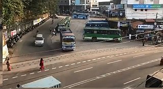
Parappanangadi is a major town and a municipality in Tirurangadi taluk of Malappuram district, Kerala, India. It is a coastal town located close to the Arabian Sea.

Vengara is a town in Malappuram district of Kerala state, India. It is situated in the Vengara Grama Panchayat and is located in Tirurangadi Taluk.

Thenhipalam is a census town and a panchayat in Tirurangadi taluk in Malappuram district of Kerala, India, with a population of 27,273 as per 2001 census, consisting of 13,293 males and 13,980 females. Tenhipalam forms a portion of the Malappuram metropolitan area as of 2011 Census. University of Calicut, the first university in the Malabar region, is located north-west part of the Panchayat. 'Chelari' is the main commercial place in Tenhipalam panchayat while 'Panambra' is considered the headquarters of the panchayat. The small town between Chelari and the university is called Kohinoor.
Eranad also known as Ernad refers to the erstwhile province in the midland area of Malabar, consisting of Malappuram and nearby regions such as Anakkayam, Manjeri, Kondotty, Nilambur, etc. Currently Eranad Taluk is a Taluk in Malappuram district. Eranad was ruled by a Samanthan Nair clan known as Eradis, similar to the Vellodis of neighbouring Valluvanad and Nedungadis of Nedunganad. The rulers of Eranad were known by the title Eralppad/Eradi. They also used the title Thirumulpad.

PonnaniTaluk is a district in India.
Tirur Taluk comes under Tirur revenue division in Malappuram district in the Indian state of Kerala. Its headquarters is the town of Tirur. Tirur Taluk contains four municipalities - Tanur, Tirur, Kottakkal, and Valanchery. Most of the administrative offices are located in the Mini-Civil Stations at Tirur, Kuttippuram, and Tanur. Most of the villages in present-day Tirur Taluk were parts of the medieval Kingdom of Tanur (Vettathunadu). The port of Tanur was an important port town in the southwestern coast of India during medieval period.

Poocholamad is a village in Kannamangalam in the Malappuram district, state of Kerala, India. It is part of the Gram Panchayat government. It is also included in Vengara Assembly constituency and Malappuram Lokhasabha constituency.
Chaliyam is a village situated at the estuary of Chaliyar in Kozhikode district of Kerala, India. Chaliyam forms an island, bounded by the Chaliyar in the north, and River Kadalundi in south, and the Conolly Canal in the east. It is located just opposite to Beypore port. Chaliyam was the former terminus of the South-West Line of the Madras Railway. Chaliyam is also famous for the Guinness World Records holder Muhammed Adil, a P.M who covered around seven km in the Chaliyar River with his hand and legs tied with ropes.
Karingapara is a small village/hamlet in Tirur Taluk in Malappuram District of Kerala State, India that comes under Ozhur Panchayath.

Malappuram district is an education hub of the state of Kerala, India with four universities, two medical colleges, two law colleges and several engineering and arts colleges. The city has several educational institutions from the school level to higher education. Kendriya Vidyalaya, Jawahar Navodaya Vidyalaya, Malabar Special Police HSS, Government Girls Higher secondary school, Govt. Boys, St.Gemmas HSS, Islahiya HSS, A.U.P School, Sree Arunodaya Vidya Nigethan etc. to name a few schools. The city is lacking an Engineering College under Government despite having the largest number of students appearing and excelling in respective entrance exams. Govt. College, Malappuram, which is the oldest college in the city, started in 1972, College of Applied Science Malappuram and Govt. College for Women started this year along with many other private colleges serves the higher educational purpose. Govt.TTI and MCT TTI are few teachers training institutes. The Regional Directorate of Higher Secondary Education and Regional Office (Malabar) of State Open School are located in the city inside the Civil Station.
Malappuram is one of the 14 districts in the South Indian state of Kerala. The district has a unique and eventful history starting from pre-historic times. During the early medieval period, the district was the home to two of the four major kingdoms that ruled Kerala. Perumpadappu was the original hometown of the Kingdom of Cochin, which is also known as Perumbadappu Swaroopam, and Nediyiruppu was the original hometown of the Zamorin of Calicut, which is also known as Nediyiruppu Swaroopam. Besides, the original headquarters of the Palakkad Rajas were also at Athavanad in the district.

Tirurangadi Muslim Orphanage is an educational hub of ten educational organizations situated in and around Tirurangadi town in Malappuram district, Kerala, India. P.S.M.O.College is the biggest campus in the entire group.

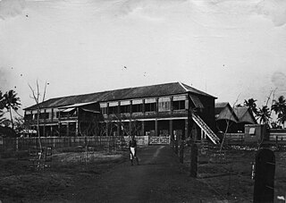
The Tirurangadi Taluk Office, also known as Hajur Kacheri, is a historic building located in Tirurangadi Talk of Malappuram District in the Indian state of Kerala. It houses the Tirurangadi Taluk Office since the post-independence Malabar District or British-era Madras Presidency. The Taluk office, which was once the Hajur Kacheri (Huzur Office) under the British, was one of the major administrative centers of the British government in Malabar region. The building also functioned as the headquarters of a short-lived Khilafat government during the rebellion.


