Chemmad

Last updated

Chemmad
ചെമ്മാട്
Town
DHIU Main Block.jpg
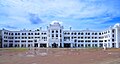
Main block of Darul Huda Islamic University, Chemmad
India Kerala location map.svg
Red pog.svg
Chemmad
Location in Kerala, India
India location map.svg
Red pog.svg
Chemmad
Chemmad (India)
Coordinates: 11°02′31″N75°54′40″E / 11.042°N 75.911°E / 11.042; 75.911
CountryFlag of India.svg India
State Kerala
District Malappuram
Area
  Total
11.56 km2 (4.46 sq mi)
Elevation
7 m (23 ft)
Population
 (2011)
  Total
43,632
  Density3,800/km2 (9,800/sq mi)
Languages
  Official Malayalam, English
Time zone UTC+5:30 (IST)
Vehicle registration KL-65

Chemmad is a town and commercial hub of Tirurangadi in the Malappuram district of Kerala, India.

Contents

Geography

Chemmad is located approximately 7 km (4.3 mi) east of Parappanangadi railway station and falls under the jurisdiction of the Tirurangadi Police Station.

Education establishments

See also

References

  1. "KMMMO Arabic College listing – Justdial" . Retrieved 2 September 2025.
  2. "KMMMO Arabic College – institute details" . Retrieved 2 September 2025.
  3. "KMMMO Arabic College – Affiliation & establishment year" . Retrieved 2 September 2025.
  4. "About DHIU – Mission and Vision". Darul Huda Islamic University. Retrieved 2 September 2025.
  5. "Darul Huda Islamic University to start educational institutes in four states". TwoCircles.net. 25 December 2017. Retrieved 2 September 2025.