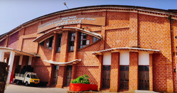
Kottakkunnu Kottakkunnu Hill Station | |
---|---|
Hill station | |
Coordinates: 11°02′53″N76°04′59″E / 11.048°N 76.083°E | |
Country | India |
State | Kerala |
District | Malappuram |
Languages | |
Time zone | UTC+5:30 (IST) |
Kottakkunnu is a hill station in Malappuram district of Kerala state, India. Widely known as Kotta Kunnu, it is situated at a height of 915 metres and is a popular tourist destination in the state of Kerala located at Malappuram. [1]
The name Kottakunnu comes from the fort built here when the area was the military headquarters of the Calicut rulers Zamorins . Due to the geographical importance of this area, the fort known as Malappuram Fort was built here and the city of Malappuram came up.
These areas became part of Valluvanad after the Perumal rule of the Chera kingdom that ruled Kerala in ancient times.
At the end of a mountain, the place is a strategic area that is three parts river, one part deep gorge and the upper part is flat like a pedestal. The modern city is spread over the slope of this hill and the plains below.
Kuruva Arangottu Swarupam, located 5 km across the river at a place called Makkaraparambu, is the root of Valluvanad Dynasty.Their capital, Angadipuram (Thirumandhamkkunu) is situated 15 km across the river. At that time, the trade was carried out through water route.The river Cherupuzha originates from the Amminikad mountain, which flows through the prominent lands of Valluvanad such as Thirumadhamkkunnu, Arangottu Swarupam and joins the Kadalundi river below this hill, which highlighted the political and the commercial importances of this area in the history.
By the twelfth century, the Eradis of Nediyiruppu Swarupam near Kondotty established a kingdom in South Malabar with their headquarters at Calicut. They were the founders of the Zamorins dynasty. Each of the other kingdoms became a part of Calicut through military operations by land and sea with support of Kshatriya Nair (a martial caste in Hinduism) and Moplah Muslim soldiers. Malappuram and the surrounding area were subjugated from Valluvakonathiri under the leadership of Varakkal Paranambisan. Thacharakavil Eradis, who were the relatives of Nediyiruppu Swarupam defeated Muthan tribes who were the rulers of the Nilambur forest and the region became part of the Zamorins' kingdom. The Muthans, who lost their kingdom through fraud, risked their pride and took refuge in the mountains so as not to live as slaves. Their generation, called Malamuthans (Mala in Malayalam mountain), who are still aloof from other peoples, are scattered in the mountains that are part of the Western Ghats in today's panchayats like Urangattiri, Edavanna, Mampad and Chaliyar. The Eradis of Thacharakavil were the founder of Nilambur Kovilakam. Under head and controller of Calicut port Shah Bandar Koya, with the help of Thirumalasseri Namboothiri and Kalpakanchery Tambrans, attacked Thirunavaya and got the authority from Valluvakonathiri to hold the position of Raksha Purusha (Great protector) in Mamangam ( a 28-day-long trade festival celebrated once every 12 years in Kerala on the banks of the Bharathappuzha). After this incident Valluvakonathiri started to send Chaveras (victory or death army) to kill Zamorin during the Mamangam festival to regain the patronage.
Varakkal Paranabisan, who conquered Malappuram and the surrounding area from Valluvakonathiri, built a fort on top of Kottakunnu. The gates of the fort are the places known today as the commercial center Kottapadi (Fortgate) at Downhill and Moonampadi ( Third gate) on the Nilambur road. Paranambi ruled Ernad with Kottapadi as the headquarters and continued military operations against Valluvanadu and other kingdoms with Kottakkunnu fort as the military center. After the Zamorins conquered the part of the Kadalundi river where the Cherupuzha joins, it became necessary to pay taxes in Malappuram to bring the goods from the Valluvanadu to the Sea port or forced to sell to the traders of Calicut which resulted formation of small trade center in the area called Kootilangadi. During the staring of 18th century the Paranambi of the time was defeated in a battle with Puntrakonathiri, the ruler of Kottakkal, and was captured by the enemy soldiers. The Moplah Muslim traders fought them and released Paranambi. Pleased with this, Paranambi built the famous Jama mosque near the Kadalundi river and a commercial center developed around the mosque known as Valiyangadi. With this, in the early 1700s, Malappuram became a commercial center beyond being a military center.
Apart from Valluvanad, the military operations of Zamorins were threatened, Palakkad's ruler, Palakkattu Achan, who asked for help from Mysore Wodeyar King's Dindigul governor Hyder Ali, Hyder Ali's army conquered Malabar and realizing the failure, the then Zamorin set fire to his ammunition and committed suicide. With this, the mamangam that the Zamorins held the patronage came to an end.
In the meantime, the administration of Mysore came into the hands of Hyder Ali and after Hyder Ali his son Tippu Sultan became the rulers of Malabar under Mysore. During Tippu's time Malappuram fort was developed and cannons, ammunition etc. were brought from Mysore and made into a strong military centre. Many roads were constructed to link Malappuram fort. Malappuram-Thamarassery road, Malappuram-Palakkad road, Malappuram-Feroke road, Malappuram-Parappanangadi road, Malappuram-Kolathur-Pattambi road were the roads built at that time. Tippu Sultan decided to build a fort centered on Feroke as the headquarters of Malabar. The roads were connected with Palakkad Fort, Feroke Fort, Ramagiri Fort near Pattambi, Palur Fort, Thamarassery Pass, Karakur (Nadugani) Pass, Sispara Pass and Walayar Pass etc..
The agrarian reforms of Tippu Sultan and a Brahmin named Madanna, who was the Receiver Governor of Malabar during the reign of the Mysore Sultans, favored the tenant farmers and cost the landlords. Reforms in taxation according to the level of agricultural production, giving privilege to agricultural land to first-time farmers on barren land, and taxing landlords on their agricultural products caused many landlords to oppose Tippu. Landlords like Pazassi king and Manjeri Athan Kurikkal (Hassan Gurukkal) turned against Tippu along with the British East India company. The Manjeri Athan Kurikkal was the tax collector and ammunition keepers in Manjeri during the reign of Zamorins. Manjeri Kovilakam which was related to Valluvakonathiri, was Tippu's administrative representative in Manjeri . The Athan Kurikkal demolished Manjeri Kovilakam and Tippu came to know about this and captured the Athan Kurikkal in a military operation and imprisoned in Mysore.
In 1792 Tippu sultan defeated by British in the Third Anglo-Mysore War, ceded Malabar to the British alliance under the Treaty of Srirangapattana and released all the prisoners, including the Athan Kurikkal of Malabar. The Malappuram fort came under the control of the Athan Kurikkal. Malabar was annexed by the British to the Bombay Presidency and made a direct colony of Britain and only certain people were empowered to collect taxes. This led to the opposition of Pazhassi King, Athan Kurikkal and others who helped the British against Tippu. British came to know that Pazhassi king was try to start alliance with Tippu, they gave many temptations to Pazhassi and the Athan Kurikkal . But they rejected the temptations and launched many protests against the British. When Tippu was killed at Srirangapatna in 1799, the British retaliated strongly against them.
In 1806, Manjeri Athan Kurikkal was killed in the battle of Mappattukara near Pattambi and thus Malappuram Fort came under the British.
The beautiful view from the top of the Malappuram hill and the gentle breeze made the area a British military base. Some British documents refer to Malappuram hill as one of the most beautiful military bases in India. Malappuram was also known as the last military center of the British Empire in the southern part of India at that time. Malappuram fort was demolished and a gunnery training center was built there. In the 1800s, the anti-British rebellions in South Malabar, known as the Moplah Rebellions, led to the establishment of several military bases in and around Malappuram. A paramilitary unit called Malappuram Special Police was established in Malappuram in 1885. During the Malabar uprising against British empire in 1921, it was raised as the Malabar Special Police. During the Malabar War of 1921, several British military units such as the Leinster Regiment and the Dorset Regiment were encamped in Malappuram.The Leinster Regiment, a military unit of Southern Ireland was the last military alliance with the British soldiers at Malappuram in 1921. After that, Southern Ireland became an independent republic from Britain.
During British rule, a military court was established at Kottakunnu and many freedom fighters were tried and executed.
Variyankunnath Kunjahmad Haji, British rebel ruler during Malabar uprising, and his two assistants were tried and shot dead by the British court on the afternoon of January 20, 1922, on the northern slopes of Kottakunnu. It was there that his body and the documents of the British rebel state he established as the Malayalam Rajyam were burnt. Now Malappuram Municipality has built a town hall in his memory below Kottakunnu.
After British rule in 1947, many British military bases including Kotakunnu in Malappuram came under the Department of Defence under Central Ministry of India . The main military headquarters is the present District Collectorate of Malappuram . Apart from the Malabar Special Police, a paramilitary force under the Kerala Police, other military centers were abolished. In 1956, when Malabar, which was a part of Madras State, was annexed to Kerala State, a section of Malabar Special Police was transferred to Tamil Nadu under the name of Madras Special Police.
Malappuram is a region with the highest number of football fans in India. But there were few spacious places to play football. Big games have to wait until the paddy fields are harvested. As a result of Malappuram Municipality's constant efforts to build an international football stadium, Central Government of India handed over Kottakunnu to the Malappuram Municipality in 1996. But as studies have shown that Kottakunnu is an ecologically fragile area, so the construction of stadium will cause ecological problems. Then the stadium was constructed at Payyanad near Manjeri and instead of the stadium a beautiful garden was built in Kottakunnu. Today many entertainment centers like art gallery, amusement park, children's park etc... have been built there.
On May 17, 1998, the Kudumbasree mission, a women's empowerment scheme of the Government of Kerala, was inaugurated by the Prime Minister Atal Bihari Vajpayee at Kottakunnu.
On August 9, 2019, three people, including a child, died in a landslide in Kottakunnu due to heavy rain.
Malappuram, is one of the 14 districts in the Indian state of Kerala, with a coastline of 70 km (43 mi). The most populous district of Kerala, Malappuram is home to around 13% of the total population of the state. The district was formed on 16 June 1969, spanning an area of about 3,554 km2 (1,372 sq mi). It is the third-largest district of Kerala by area. It is bounded by Western Ghats and the Arabian Sea on either side. The district is divided into seven Taluks: Eranad, Kondotty, Nilambur, Perinthalmanna, Ponnani, Tirur, and Tirurangadi.
Palakkad is one of the 14 districts in the Indian state of Kerala. It was carved out of the southeastern region of the former Malabar District on 1 January 1957. It is located at the central region of Kerala and is the second largest district in the state after Idukki. The city of Palakkad is the district headquarters. Palakkad is bordered on the northwest by the Malappuram district, on the southwest by the Thrissur district, on the northeast by Nilgiris district, and on the east by Coimbatore district of Tamil Nadu. The district is nicknamed "The granary of Kerala". Palakkad is the gateway to Kerala due to the presence of the Palakkad Gap, in the Western Ghats. The 2,383 m high Anginda peak, which is situated in the border of Palakkad district, Nilgiris district, and Malappuram district, in Silent Valley National Park, is the highest point of elevation in Palakkad district. Palakkad city is about 347 kilometres (216 mi) northeast of the state capital, Thiruvananthapuram.
Valluvanad was an independent chiefdom in present-day central Kerala that held power from the early 12th century to the end of the 18th century. Prior to that, and since the late 10th century, Valluvanad existed as an autonomous chiefdom within the kingdom of the Chera Perumals. The disintegration of the Chera Perumal kingdom in early 12th century led to the independence of the various autonomous chiefdoms of the kingdom, Valluvanad being one of them.
Manjeri is a major town and municipality in Malappuram district, Kerala, India. It is the fourth-most populous municipality in state. It is situated 23 kilometres (14 mi) southeast to Karipur International Airport and 13 kilometres (8.1 mi) northeast to Malappuram, the district headquarters, and forms a part of Malappuram metropolitan area. It is one of the major commercial towns under the Malappuram urban agglomeration and serves as the headquarters of Eranad Taluk. Manjeri Municipality is a Local Self Government Institution with a jurisdiction of three villages namely Manjeri, Payyanad, and Narukara.
Kottakkal is a major municipal town in Malappuram district in Kerala, southern India having 32 wards. it is a part of Malappuram metropolitan area and a growing city in Kerala. The town is best known for the Arya Vaidya Sala, one of the top Ayurvedic health centres of the world. Kottakkal is also a major growing commercial, educational, and healthcare hub in South Malabar. The town lies on Mumbai–Kanyakumari National Highway 66.
Malabar District, also known as Malayalam District, was an administrative district on the southwestern Malabar Coast of Bombay Presidency (1792–1800), Madras Presidency (1800-1937), Madras Province (1937–1950) and finally, Madras State (1950-1956) in India. It was the most populous and the third-largest district in the erstwhile Madras State. The historic town of Calicut was the admisnitrative headquarters of this district.
Feroke is a Municipality and a part of Kozhikode metropolitan area under Kozhikode Development Authority (K.D.A) in the Kozhikode district of the Indian state of Kerala.
Malappuram is a city and the headquarters of the Malappuram district in Kerala, India. It is the 4th largest urban agglomeration in Kerala and the 20th largest in India. The city is spread over 158.20 km2 (61.08 sq mi) including the surrounding suburban areas. The first municipality in the district formed in 1970, Malappuram serves as the administrative headquarters of Malappuram district. Divided into 40 electoral wards, the city has a population density of 4,800 per square kilometre. According to the 2011 census, the Malappuram metropolitan area is the fourth largest urban agglomeration in Kerala after Kochi, Calicut, and Thrissur urban areas and the 20th largest in India with a total population of 3 million. It is the fastest growing city in the world with a 44.1% urban growth between 2015 and 2020 as per the survey conducted by Economist Intelligence Unit (EIU) based on the urban area growth during January 2020. Malappuram is situated 54 km southeast of Calicut and 90 km northwest of Palakkad. It is the first Indian municipal body to provide free Wi-Fi connectivity to its entire residents. Malappuram is also the first Indian municipal body to achieve the International Organization for Standardization certificate. It is also the first complaint-free municipality in the state.
Ramanattukara is a municipality census town in Kozhikode district in the Indian state of Kerala. This town was formerly called Kadungan Chira village. Ramanattukara is located 15 km away from Kozhikode city.
The Samoothiri was the title of the erstwhile ruler and monarch of the Kingdom of Kozhikode (Calicut) in the South Malabar region of India. Originating from the former feudal kingdom of Nediyiruppu Swaroopam, the Samoothiris and their vassal kings from Nilambur Kovilakam established Calicut as one of the most important trading ports on the southwest coast of India. At the peak of their reign, they ruled over a region extending from Kozhikode Kollam to the forested borders of Panthalayini Kollam (Koyilandy). The Samoothiris belonged to the Eradi subcaste of the Samantan community of colonial Kerala, and were originally the ruling chiefs of Eranad. The final Zamorin of Calicut committed suicide by setting fire to his palace and burning himself alive inside it, upon learning that Hyder Ali had captured neighboring country of Chirackal in Kannur.
Valanchery is a major municipal town in Malappuram district, Kerala, India. It is one of the four municipalities in Tirur Taluk, besides Tirur, Kottakkal, and Tanur. It is situated about 40 kilometres (25 mi) southeast to Karipur International Airport and 25 kilometres (16 mi) southwards to the district headquarters, and forms a part of Malappuram metropolitan area. It is also one of the major commercial towns under the Malappuram urban agglomeration. Valanchery, which was a part of the erstwhile princely state of the Valluvanad in the early medieval period, had been under the direct control of the Zamorin of Calicut following the Tirunavaya war of 14th century CE. During British Raj, Valanchery was included in the Ponnani Taluk of erstwhile Malabar District.
Kadalundi is a village in Kozhikode district, Kerala, India. It is a coastal village close to the Arabian Sea. Kadalundi is famous for its bird sanctuary, which is home to various migratory birds during certain seasons and has been recently declared as a bio-reserve. The Kadalundi-Vallikkunnu community reserve is the first community reserve in Kerala. The Kadalundi River and the Chaliyar river, two of the longest rivers of Kerala, merges with the Arabian Sea at Kadalundi. The first railway line in Kerala was laid in 1861 from Tirur to Chaliyam through Tanur, Parappanangadi, Vallikkunnu, and Kadalundi.
Eranad also known as Ernad refers to the erstwhile province in the midland area of Malabar, consisting of Malappuram and nearby regions such as Anakkayam, Manjeri, Kondotty, Nilambur, etc. Currently Eranad Taluk is a Taluk in Malappuram district. Eranad was ruled by a Samanthan Nair clan known as Eradis, similar to the Vellodis of neighbouring Valluvanad and Nedungadis of Nedunganad. The rulers of Eranad were known by the title Eralppad/Eradi. They also used the title Thirumulpad.
The Mysorean invasion of Malabar (1766–1792) was the military invasion of the Malabar region of Kerala, including the territories of the Zamorin of Calicut, by the then-de facto ruler of the Kingdom of Mysore, Hyder Ali. After the invasion, the Kingdom of Cochin to the south of Malabar became a tributary state of Mysore.
The British got Malabar from Tippu Sultan in 1792. But Malabar was a province that was plagued by refraction, unrest and insurgency as early as 1766—when Hyder Ali occupied whole of Malabar. Two decades of Mysore effort to subjugate this province ended up in chaos and confusion in Malabar with a part of her population either dead or migrated and once prosperous economy destroyed.
Nilambur Kovilakam, also known as Nilambur Kingdom or Nilambapuri, was a former vassal kingdom and royal Kovilakam in present-day Kerala, India, situated near to the Nilgiri range of the Western Ghats. It was ruled by Samantha Kshatriyas who were the family members and representatives of the Samoothiri (Zamorin), and also established marriage relations with the Nambudiris. They served as vassal kings to the Zamorin, with their capital located 25 kilometers north of Manjeri in present-day Malappuram district. They built several aristocratic Tharavads, such as the Nambudiri tharavad of Pootheri Illam in Feroke, and married into the Zamorin's own family from Nediyiruppu Swaroopam.
Ravi Varma Raja (1745–1793) was a Samantan Nair warrior prince of the Royal House of Zamorins from Calicut who fought a two-decade long revolt against the Mysore Sultanate under Hyder Ali and Tipu Sultan between 1766–1768 and 1774–1791, and later the British East India Company in 1793.
The Kingdom of Kozhikode, also known as Calicut, was the kingdom of the Zamorin of Calicut, in the present-day Indian state of Kerala. Present-day Kozhikode is the second largest city in Kerala, as well as the headquarters of Kozhikode district.
Chaliyam is a village situated at the estuary of Chaliyar in Kozhikode district of Kerala, India. Chaliyam forms an island, bounded by the Chaliyar in the north, and River Kadalundi in south, and the Conolly Canal in the east. It is located just opposite to Beypore port. Chaliyam was the former terminus of the South-West Line of the Madras Railway. Chaliyam is also famous for the Guinness World Records holder Muhammed Adil, a P.M who covered around seven km in the Chaliyar River with his hand and legs tied with ropes.
Malappuram is one of the 14 districts in the South Indian state of Kerala. The district has a unique and eventful history starting from pre-historic times. During the early medieval period, the district was the home to two of the four major kingdoms that ruled Kerala. Perumpadappu was the original hometown of the Kingdom of Cochin, which is also known as Perumbadappu Swaroopam, and Nediyiruppu was the original hometown of the Zamorin of Calicut, which is also known as Nediyiruppu Swaroopam. Besides, the original headquarters of the Palakkad Rajas were also at Athavanad in the district.