Thodupuzha is a municipality and Taluka in the Idukki district of Kerala, India. It is located 55 km (34.2 mi) west of the district headquarters in Painavu and about 192 km (119.3 mi) north of the state capital Thiruvananthapuram. As per the 2011 Indian census, Thodupuzha has a population of 52,045 people, and a population density of 1,468/km2 (3,800/sq mi).

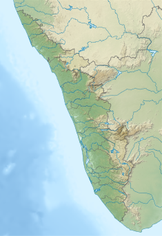
Idukki is one of the 14 districts in the Indian state of Kerala in the southwest of the country. It is the largest district in Kerala and lies amid the Cardamom Hills of Western Ghats in Kerala. Idukki district contains two municipal towns – Kattappana and Thodupuzha, and five taluks.

Muvattupuzha is a municipality in the Ernakulam district of Kerala, India. It is located 26 km (16.2 mi) east of the district headquarters in Thrikkakara and about 170 km (105.6 mi) north of the state capital Thiruvananthapuram. As per the 2011 Indian census, Muvattupuzha has a population of 30,397 people, and a population density of 2,306/km2 (5,970/sq mi).

Periyar, is the longest river and the river with the largest discharge potential in the Indian state of Kerala. It is one of the few perennial rivers in the region and provides drinking water for several major towns. The Periyar is of utmost significance to the economy of Kerala. It generates a significant proportion of Kerala's electrical power via the Idukki Dam and flows along a region of industrial and commercial activity. The river also provides water for irrigation and domestic use throughout its course besides supporting a rich fishery. Due to these reasons, the river has been named the "Lifeline of Kerala". Kochi city, in the vicinity of the river mouth, draws its water supply from Aluva, an upstream site sufficiently free of seawater intrusion. Twenty five percent of Kerala's industries are along the banks of the Periyar. These are mostly crowded within a stretch of 5 kilometres (3 mi) in the Eloor-Edayar region (Udhyogamandal), about 10 kilometres (6 mi) north of Kochi harbor.

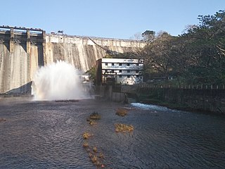
The Idukki Dam is a double-curvature arch dam constructed across the Periyar River in a narrow gorge between two granite hills locally known as Kuravan and Kurathi in Idukki district in the state of Kerala, India. It is constructed and owned by the Kerala State Electricity Board. It supports a 780 MW hydroelectric power station in Moolamattom, which started generating power on 4 October 1975. At 168.91 metres (554.2 ft), it is one of the highest arch dams in Asia. The Indo-Canadian project was inaugurated by the Prime Minister Indira Gandhi on February 17, 1976.
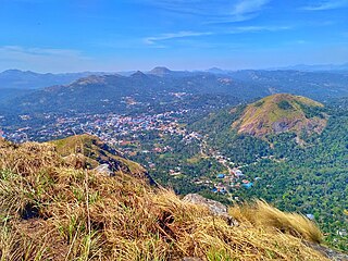
Kattappana ([kaʈ:ap:ɐna]) is a municipality in the Idukki district of Kerala, India. It is located 21 km (13.0 mi) southeast of the district headquarters in Painavu and about 140 km (87.0 mi) north of the state capital, Thiruvananthapuram. Kattappana is the second-largest municipality in the district by population, and serves as a major hub for commercial and economic activity for the surrounding region.

Thodupuzha River has its origins in the Thodupuzha Taluk in the Idukki district of Kerala, India, and is a tributary of the Muvattupuzha river. The river is one of the few in the state that does not become dry in the summer as the outflow from the Idukki hydro-electric project is drained into this river via Kanjar river. The town Thodupuzha is on the banks of this river, hence it got the name Thodupuzha.

The Ponmudi Dam is a concrete gravity dam built across the Panniyar river which is a tributary of Periyar river at Konnathady panchayath of Konnathadi village in Idukki district of Kerala, India. The dam was constructed in 1963 as a part of a hydroelectric project. Construction was led by E.U.Philipose, Superintending Engineer, Kerala State Electricity Board. It has a length of 288.80 metres (947.5 ft). The hydropower component of the dam has an installed capacity of 30 MW with firm power of 17 MW, generating 158 GWh annually. Taluks through which the river flow are Udumbanchola, Devikulam, Kothamangalam, Muvattupuzha, Kunnathunadu, Aluva, Kodungalloor and Paravur.
Chimmini Dam is situated in Echippara in Chalakudy taluk of Thrissur District of Kerala state of India. It is constructed across Kurumali river, a tributary of the Karuvannur river. Chimmini is the largest dam of Thrissur district. The Chimminy Wild Life Sanctuary is located close to the dam. Construction of the 495-metre masonry and 686-metre earthen dam started in 1975 and it was completed in 1996. Total cost of the project was Rs 59.71 crore although the cost of construction of the dam was initially estimated at Rs 36.15 crore.
Moolamattom is the headquarters of Arakulam Panchayath in Thodupuzha Taluk, Idukki district in Kerala, India. It lies 22 km from Thodupuzha, on the banks of the Thodupuzha River, a tributary of the Muvattupuzha river. Moolamattom is famous for India's second largest underground hydroelectric power station - Moolamattom hydro power station.

Muttom is a rural area in Idukki district in the Indian state of Kerala. This place is 8.5 km away from Thodupuzha and 66 km away from Kochi. Geographically this place is part of Midland or Idanad region of Kerala.

The Cheruthoni Dam, located in Idukki District, Kerala, India, is a 138m tall concrete gravity dam. Preliminary work on this project was initiated under the leadership of Superintending Engineer, E.U.Philipose. This dam was constructed in 1976 as part of the Idukki Hydroelectric Project along with two other dams Idukki and Kulamavu. The Canadian government aided the project with long-term loans and grants. The dam was constructed by HCC and the consultant was S.N.C. Inc., Canada,

Kulamavu Dam is a gravity/masonry dam on Kilivillithode, which is a tributary of the Periyar river in Arakkulam village, Idukki district in the Indian state of Kerala. It is one of three dams associated with the Idukki hydroelectric power project in the Indian state of Kerala. This dam is located towards the western side of the Idukki Arch Dam. This is a gravity dam with the top portion in concrete and the bottom in masonry.

Erattayar Dam is a small, diversion dam built on the Erattayar river in Erattayar grama panchayat near Kattappana town in Idukki district of Kerala, India. It acts mainly as a diversion dam to supply water to the Idukki dam. Diversion of water from Erattayar forebay to Idukki reservoir is through a tunnel called Anchuruli tunnel which is 3.77 km (2.34 mi) long. Construction of the dam was completed in the year 1989.

Kallar Dam is a small, diversion dam constructed at Perinjamkutty river in Nedumkandam grama panchayat of Idukki district, Kerala, India. It acts mainly as a diversion dam to supply water to the Idukki dam.

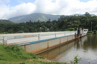
Kallarkutty Dam is a gravity dam built on the Muthirapuzha river, a tributary of the Periyar river, as part of the Neriamangalam Hydroelectric Project at Kallarkutty in Vellathooval panchayat of Idukki district in Kerala, India. The water discharged from the Chenkulam dam's powerhouse and the Muthirapuzha river is diverted to the Neriamangalam powerhouse near Panamkutty above the Pambla dam. The Hydroelectric Project was commissioned on 27 January 1961 to generate 45 MW of power using 3 turbines with a capacity of 15 MW. In 2006, the project was upgraded from 45 MW to 52.65 MW. Taluks through which release flow are Udumbanchola, Devikulam, Idukki, Kothamangalam, Muvattupuzha, Kunnathunadu, Aluva, Kodungalloor and Paravur. The Project was led by Kerala State Electricity Board Engineer E.U. Philipose
Chenkulam Dam is a gravity dam located on the Muthirapuzha river in Vellathooval panchayat of Idukki district in the Indian state of Kerala. It spans 144.50 metres (474.1 ft) long and stands 26.82 metres (88.0 ft). It hosts a 48 MW power plant.
Narakakkanam Weir is a diversion dam constructed across Narakakkanam River in Mariyapuram panchayath of Thankamani Village in Idukki district in Kerala, India. Narakakkanam weir is an augmentation weir for the Idukki Hydro Electric Project. Narakakkanam, Azhutha, Vazhikkadavu, Vadakkepuzha and Kuttiar diversion schemes were later added to augment the Idukki reservoir. The height of the dam is 11.50 metres (37.7 ft) from the deepest foundation and length is 45.20 metres (148.3 ft).
Vadakkepuzha Weir is a diversion dam of Earthen type constructed across Vadakkepuzha which is a tributary of Muvattupuzha river in Arakkulam village in Idukki district of Kerala, India. Vadakkepuzha weir is a part of an augmentation scheme for the Idukki Hydro Electric Project. Narakakkanam, Azhutha, Vazhikkadavu, Vadakkepuzha and Kuttiar diversion schemes were later added to Idukki HEP to augment the reservoir. Water from the reservoir is pumped in to Idukki reservoir through a pump house with three pumps.

The Moolamattom hydro power station is the power house of the Kerala State Electricity Board's Idukki Hydroelectric Project, the largest hydroelectric project in Kerala, India, with a capacity to generate 2398 million units of electricity annually. Located on the banks of Muvattupuzha River at Moolamattam in Arakulam Gram Panchayat of Thodupuzha Taluk eof Idukki district, it is one of the largest underground hydroelectric power stations in India. The power house has an installed capacity of 780 MW. In the three dams of this hydroelectric project, the water needed to generate electricity at the Moolamattam power station is pumped through tunnels near the pond level.