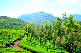
Munnar is a town and hill station located in the Idukki district of the southwestern Indian state of Kerala. Munnar is situated at around 1,600 metres (5,200 ft) above mean sea level, in the Western Ghats mountain range. Munnar is also called the "Kashmir of South India" and is a popular honeymoon destination.

Kodaikanal is a municipality and hill station in Dindigul district in the state of Tamil Nadu, India. It is situated at an altitude of 2,225 m (7,300 ft) in the Palani hills of the Western Ghats. Kodaikanal was established in 1845 to serve as a refuge from the high temperatures and tropical diseases during the summer in the plains. It is a popular tourist destination and is referred to as the "Princess of Hill stations" with much of the local economy is based on the hospitality industry serving tourism. As per the 2011 census, the city had a population of 36,501.

Anamudi is a mountain located in Ernakulam district and Idukki district of the Indian state of Kerala. With an elevation of 2,695 metres (8,842 ft) and a topographic prominence of 2,479 metres (8,133 ft), it is the highest peak in the Western Ghats and in South India.

Marayur or Marayoor is a town in Devikulam taluk of Idukki district in the southwestern Indian state of Kerala. It is located 42 kilometers north of Munnar on SH 17 connecting Munnar with Udumalpet, Tamil Nadu. Marayur is situated at around 990 metres above mean sea level and is the only place in Kerala that has natural sandalwood forests. Ancient dolmens and rock paintings in Marayur date back to the Stone Age. In 1991 Marayur had a population of 9,590.

Strobilanthes kunthiana, known as Kurinji or Neelakurinji in Tamil language and Malayalam and Gurige in Kannada, is a shrub of the bear's breeches family (Acanthaceae) that is found in the shola forests of the Western Ghats in Kerala, Karnataka and Tamil Nadu. The purplish blue flower blossoms only once in 12 years, and gave the Nilgiri Mountains range its name as nil (blue) + giri (mountains). The name Neelakurinji originates from the Malayalam language neela (blue) + kurinji (flower). Of all long interval bloomers Strobilanthes kunthiana is the most rigorously demonstrated, with documented bloomings in 1838, 1850, 1862, 1874, 1886, 1898, 1910, 1922, 1934, 1946, 1958, 1970, 1982, 1994, 2006, 2018 and 2022, these have no match to Solar cycles.

Kerala State Electricity Board (KSEB) is an Indian public sector undertaking under the Government of Kerala that generates, transmits and distributes electricity in the state under government monopoly. Established in 1957, the agency comes under the authority of the Department of Power. It has been registered under Indian Companies Act 1956 in January 2011.

Udumalai, also known as Udumalaipettai and Udumalpet, is a town in Tiruppur district in the Indian state of Tamil Nadu. It is located 535 km south west from the state capital, Chennai and 72 km from Coimbatore. It is the headquarters of Udumalaipettai taluk and had a population of 61,133 as per 2011 Census of India. The town comes under the Udumalaipettai Assembly constituency.

Top Station is a tourist destination located in Theni district of Tamil nadu. Top Station is notable as the historic transshipment location for Kannan Devan tea delivered there from Munnar and Madupatty by railway and then down by ropeway to Kottagudi. This area is popular for the rare Neelakurinji flowers. The Kurinjimala Sanctuary is nearby. Top Station is the western entrance to the planned Palani Hills National Park.

Chinnar Wildlife Sanctuary is located 18 km north of Marayoor on State Highway 17 in the Marayoor and Kanthalloor panchayats of Devikulam taluk in the Idukki district of India's Kerala state. It is one of 18 wildlife sanctuaries among the protected areas of Kerala.

Thirumoorthy Temple is situated at the foot of the Thirumoorthy hills or Thirumoorthi hills adjoining the Thirumoorthy dam. The features of the Anamalai hill range of Western Ghats, include the cascading water to the Thirumoorthy reservoir from the Panchalingam Falls. A perennial stream flows by the side of the Sri Amanalingeswarar temple. The presiding deity is called Amanalingeswara.
Kuruppampady is situated about five kilometers from Perumbavoor on the Aluva-Munnar road, in Kunnathunad Taluk, Ernakulam district, Kerala, India.
Kerala State Highway 17, also called the Northern outlet road and Munnar - Udumalpet road, is notable for passing between the Anaimalai Hills and the Palani Hills, through or near three important protected areas and providing opportunities for viewing wildlife in unspoiled forests.
The total road length is about 59.1 km (36.7 mi).
Adimali is a town in the Idukki district of Kerala, in southwesternIndia. National Highway 185 is a highway in India running from Adimali to Kumily through Kattappana and ends in Adoor in Kerala. Adimaly is located on the National Highway 49, now NH 85, known as Kochi-Dhanushkodi National Highway, earlier known as the Kochi Madhura Highway (India) connecting Kochi and Madurai, India. From Adimaly, it is only 27 kilometers to Munnar, which is a famous hill station. The waterfalls Cheeyappara, Adimali waterfalls and Valara are located nearby. Pepper and cocoa cultivation is the main agricultural activity of this place. The Ponmudi Dam was constructed in 1963 across the Panniar river, nearly 15 km southeast of Adimali, on the way to Rajakkad.Thopramkudy is the nearest town. Adimali is known for its proximity to Munnar and natural environment. Adimali has almost all the basic facilities like roads, super markets, markets, educational institutions and hospitals.
Kundala Valley Railway was the first monorail system in India, later converted to a 2 ft narrow-gauge railway, that operated in Kundala Valley, Munnar of Idukki district in Kerala, India. The railway line had 35 km length.

The Kodaikanal–Munnar Road was located in Dindigul District and Theni District of Tamil Nadu and Idukki district of Kerala in South India. It covers 81 kilometers (50 mi) from Kodaikanal to Munnar. The road was improved by the British in 1942 as an evacuation route in preparation for a possible Japanese invasion of South India. With a maximum elevation of 2,480 meters (8,140 ft) just south of Vandaravu Peak, it was among the highest roads in India, south of the Himalayas, prior to its closure in 1990.
Anikkadavu is a small village formerly a part of Coimbatore Rural District, India, but now in Tiruppur District which belongs to Udumalpet taluk. The name Anikkadavu derived from the ancient word Anai Kadavu which means that it was the path of elephants used to cross this region long long ago.

The Govt.College of Engineering Munnar is situated in the Munnar hill station of the State of Kerala, India. College of Engineering Munnar is an Institute of higher learning established by Government of Kerala and is managed by the Center for Continuing Education Kerala ( CCEK ). The Institution was started in the year 2000 and is affiliated to APJ Abdul Kalam Technological University Kerala from 2015 admission onwards. The college is approved by All India Council for Technical Education (AICTE), New Delhi. It is one of the finest engineering institutions in Kerala.The Chairman of the Governing Body of the institution is the Hon’ble Minister for Education, Government of Kerala and the Vice-Chairman is the Principal Secretary (Higher Education) Government of Kerala.
The Great flood of '99 (Malayalam:'തൊണ്ണൂറ്റി ഒമ്പതിലെ വെള്ളപ്പൊക്കം' occurred when the Periyar River in Kerala state of India flooded in the month of July 1924. This happened in the year 1099 ME in the Malayalam Calendar. As the Malayalam Calendar was popular in Kerala, the flood is generally referred to as "The Great flood of "99".The rain continued for about three weeks. Many districts of present-day Kerala were deeply submerged by the flood - from Thrissur, to Ernakulam to Idukki, Kottayam even up to Alappuzha and Kuttanad. A huge mountain called Karinthiri Mala was washed away by this flood and the road to Munnar also went along with it. As the road to Munnar was lost by this flood, a new road from Ernakulam to Munnar became necessary - the present day road from Ernakulam to Munnar was constructed after this. Kundala Valley Railway which was the first monorail system in India was also completely destroyed. Various remnants of the old Railway systems still exist at Munnar.
Pazhampillichal is a village in the High Range district Idukki of Kerala State, India. It is one of the far-flung forest fringe villages in the Munnar/Devikulam Wildlife, deciduous and evergreen forest, connecting from Aarammile which is in between Adimaly - Neriamangalam on the Munnar – Cochin State Highway.

The KDHP Tea Museum is an industry and history museum situated in Munnar, a town in the Idukki district of Kerala in South India. Tata Tea Museum is its official name, but it's also known as Nullathanni Estate where it is located, or Kannan Devan Hills Plantation (KDHP) Tea Museum.


