Muzhappilangad Beach | |
|---|---|
Beach | |
 Muzhappilangad Beach | |
 Muzhappilangad Beach  Muzhappilangad Beach | |
| Coordinates: 11°47′46.3596″N75°26′31.308″E / 11.796211000°N 75.44203000°E | |
| Location | Muzhappilangad, Tellichery, India |
| Dimensions | |
| • Length | 3.8 km |
| Patrolled by | Lifeguards |
| Hazard rating | Low |
This section needs additional citations for verification .(July 2023) |
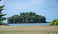
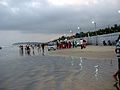
Muzhappilangad Beach is a drive-in beach in Kannur district of Kerala, on the Malabar Coast of India. It is 4 kilometers in length. [1] In 2016, it was featured among the six best beaches for driving by BBC Autos. [2] [3] The beach is currently[ when? ] under major renovation. [4]


![mulllppilngngaatt kttppurrtte baikk snycaarik[?].JPG](http://upload.wikimedia.org/wikipedia/commons/thumb/3/3d/%E0%B4%AE%E0%B5%81%E0%B4%B4%E0%B4%AA%E0%B5%8D%E0%B4%AA%E0%B4%BF%E0%B4%B2%E0%B4%99%E0%B5%8D%E0%B4%99%E0%B4%BE%E0%B4%9F%E0%B5%8D_%E0%B4%95%E0%B4%9F%E0%B4%AA%E0%B5%8D%E0%B4%AA%E0%B5%81%E0%B4%B1%E0%B4%A4%E0%B5%8D%E0%B4%A4%E0%B5%86_%E0%B4%AC%E0%B5%88%E0%B4%95%E0%B5%8D%E0%B4%95%E0%B5%8D_%E0%B4%B8%E0%B4%9E%E0%B5%8D%E0%B4%9A%E0%B4%BE%E0%B4%B0%E0%B4%BF%E0%B4%95%E0%B5%BE.JPG/120px-%E0%B4%AE%E0%B5%81%E0%B4%B4%E0%B4%AA%E0%B5%8D%E0%B4%AA%E0%B4%BF%E0%B4%B2%E0%B4%99%E0%B5%8D%E0%B4%99%E0%B4%BE%E0%B4%9F%E0%B5%8D_%E0%B4%95%E0%B4%9F%E0%B4%AA%E0%B5%8D%E0%B4%AA%E0%B5%81%E0%B4%B1%E0%B4%A4%E0%B5%8D%E0%B4%A4%E0%B5%86_%E0%B4%AC%E0%B5%88%E0%B4%95%E0%B5%8D%E0%B4%95%E0%B5%8D_%E0%B4%B8%E0%B4%9E%E0%B5%8D%E0%B4%9A%E0%B4%BE%E0%B4%B0%E0%B4%BF%E0%B4%95%E0%B5%BE.JPG)