
Nilambur is a municipality and a taluk in the Malappuram district of the Indian state of Kerala. It is located close to the Nilgiris range of the Western Ghats on the banks of the Chaliyar River. It is about 53.2 kilometers from Malappuram city and 26.8 kilometers from Manjeri on the Kozhikode–Gudalur road called CNG road.
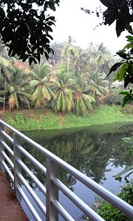
Vadapurampuzha River is one of the tributaries of the Chaliyar River. Chaliyar River is the fourth longest river in Kerala, south India at 169 km in length. It traverses through Nilambur, Mampad, Edavanna, Areekade, Vazhakkad and flows into the sea at Beypore in Kozhikode district.
Mavoor is a town situated in Kozhikode district in Kerala, India. It is 20 km away from Kozhikode city.

Kadalundi River (Kadalundipuzha) is one of the four most important rivers flowing through Malappuram district in the Indian state of Kerala. The other three are the Chaliyar, the Bharathappuzha and the Tirur River. This rain-fed river is 130 kilometres (81 mi) long and is one of the most important rivers in the district. It is formed by the confluence of the Olipuzha River and the Veliyar River.The Kadalundi originates from the Western Ghats at the western border of the Silent Valley and flows through the district of Malappuram. It has two main tributaries namely Olipuzha and Veliyar. The Kadalundi River drains an area of 1274 km² and has a length of 120 km. The Kadalundi Bird Sanctuary spreads over a cluster of islands where the Kadalundipuzha River flows into the Arabian Sea. There are over a hundred varieties of native birds and around 60 varieties of migratory birds that come here in large numbers annually.

Mampad is a growing town in Malappuram district, Kerala, India. located about 08 km east of Nilambur city. Nearby places include Edavanna, Areacode, Manjeri, Wandoor and Pandikkad. It is under the Wandoor Assembly Constituency. Kozhikode-Nilambur-Gudalur SH pass through here. The Mampad town is now developing day to day. Most people are engaged in agriculture and business activities. Hindus, Christians and Muslims co-exist in harmony adding to the diversity in faith and religion.
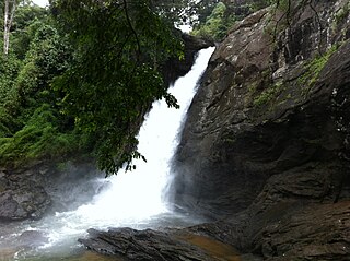
Soochipara Falls also known as Sentinel Rock Waterfalls is a three-tiered waterfall in Vellarimala, Wayanad, India. It is surrounded by deciduous, evergreen and montane forests. Locally referred to as Soochipara, the 15-20 minute drive from Meppadi to Sentinel Rock Waterfalls has views of a number of Wayanad's tea estates. The Sentinel Rock Waterfalls is 200 metres (656 feet) and offers a cliff face that is used for rock climbing. The water from Soochipara Falls later joins Chulika River or popularly known as Chaliyar River after Velarimala Hills near Cherambadi in Kerala.
Punnappuzha (Malayalam:പുന്നപ്പുഴ) is a tributary of Karimpuzha, which is the biggest tributary of the Chaliyar river in Kerala, India.
The Maruthappuzha is a tributary of the Punnappuzha in Kerala, India, which merges with the Karimpuzha and thus finally joins the Chaliyar. The Maruthappuzha originates as two separate streams from the Devala and the Pandalur areas of Nilagiri district and join near Marutha to form the Maruthappuzha. The Muringamunda Puzha and Karakkodan puzha also joins with the Maruthappuzha at Palemad and Munda respectively.
Kanjirappuzha (കാഞ്ഞിരപ്പുഴ) is a small tributary of the Chaliyar river in Nilambur taluk of Malappuram district in Kerala, India. The river originates from the mountain region which lies between Malappuram and Kozhikode districts. The river flows through Chaliyar Panchayath in Malappuram district and ultimately join to Chaliyar near Chaliyarmukku where Karimpuzha also meet Chaliyar. The Adyanpara Waterfalls are on the river.
Karimpuzha is the largest tributary of Chaliyar river, Kerala, India. It is very near to Nilambur.
Kuruvanpuzha is a tributary of Chaliyar river in Kerala, India. This river originates in the forests bordering Malappuram and Kozhikode districts in Nilambur taluk. It joins the Chaliyar near Vadapuram just before Kuthirappuzha meets Chaliyar, behind the Kerala State Wood Industries Limited. The Connolly's Plot, near the confluence of Kuruvanpuzha with Chaliyar, has the world's biggest and oldest teaks.
Cherupuzha is a tributary of Karimpuzha which is a tributary of Chaliyar river in Kerala, India. Cherupuzha originate from the south-western slopes of Mukurthi National Park in Nilgiris district of Tamil Nadu. It is a major water source for Nilambur South forest division. It join with Karimpuzha near Karulai town.
Kottappuzha is a tributary of Kuthirappuzha which is a tributary of Chaliyar river in Kerala, India. Kottappuzha originates from the western slopes of Upper Bhavani reservoir in Nilgiris district of Tamil Nadu. Near Kottappuzha palam (bridge), about 1.5 km south of Pookkottumpadam 'Chokkadan puzha' a river from Kozhippara hills and which passes through Chokkad join with Kottappuzha. At Koorad, Kottappuzha meets Kuthirappuzha.

Nilambur–Shoranur line is a 66 kilometres (41 mi) long single line, non-electrified broad gauge (1676 mm) railway spur branch line of the Indian Railways connecting Nilambur Road railway station in Malappuram district with Shoranur Junction in Palakkad district in the state of Kerala. It is a branch line administered by the Palakkad railway division of the Southern Railway zone and one of the shortest broad gauge railway lines in India.

Vallikkunnu is a village in Malappuram district in the state of Kerala, India with an area of 25 km2. Its latitude and longitude are 11'07" N and 7'51"E respectively. Vallikkunnu was awarded the best panchayath of Kerala in 1997.
Vazhakkad is a village located on the bank of River Chaliyar Kondotty Thaluk, Malappuram district, state of Kerala, India. East and some north part of Vazhakkad bordering with River Chaliyar, South Cheakode and Pulikkal Panchayaths and West Vazhayur Grama Panchayath. The nearest town is Edavannappara three kilometers away.
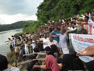
Kavungal Amakkode Abdul Rahman, popularly known as Adhrehyaka or simply Adreyi, was the founder leader of the Chaliyar agitation in Kerala, India.
Chaliyam is a village situated at the estuary of Chaliyar in Kozhikode district of Kerala, India. Chaliyam forms an island, bounded by the Chaliyar in the north, and River Katalundi in south, and the Conolly Canal in the east. Chaliyam was the former terminus of the South-West Line of the Madras Railway. Chaliyam is also famous for the Guinness world record holder Muhammed Adil.P.M who has covered around seven kms in chaliyar river with his hand and legs been tied with ropes.


