
Idukki is one of the 14 districts in the Indian state of Kerala in the southwest of the country. It is the largest district in Kerala and lies amid the Cardamom Hills of Western Ghats in Kerala. Idukki district contains two municipal towns – Kattappana and Thodupuzha, and five taluks.

Periyar, is the longest river and the river with the largest discharge potential in the Indian state of Kerala. It is one of the few perennial rivers in the region and provides drinking water for several major towns. The Periyar is of utmost significance to the economy of Kerala. It generates a significant proportion of Kerala's electrical power via the Idukki Dam and flows along a region of industrial and commercial activity. The river also provides water for irrigation and domestic use throughout its course besides supporting a rich fishery. Due to these reasons, the river has been named the "Lifeline of Kerala". Kochi city, in the vicinity of the river mouth, draws its water supply from Aluva, an upstream site sufficiently free of seawater intrusion. Twenty five percent of Kerala's industries are along the banks of the Periyar. These are mostly crowded within a stretch of 5 kilometres (3 mi) in the Eloor-Edayar region (Udhyogamandal), about 10 kilometres (6 mi) north of Kochi harbor.

The Idukki Dam is a double-curvature arch dam constructed across the Periyar River in a narrow gorge between two granite hills locally known as Kuravan and Kurathi in Idukki district in the state of Kerala, India. It is constructed and owned by the Kerala State Electricity Board. It supports a 780 MW hydroelectric power station in Moolamattom, which started generating power on 4 October 1975. At 168.91 metres (554.2 ft), it is one of the highest arch dams in Asia. The Indo-Canadian project was inaugurated by the Prime Minister Indira Gandhi on February 17, 1976.

Idukki is a township in Idukki district near to the district headquarter Painavu in the state of Kerala, southern India. The township consists of the towns of Cheruthoni, Painavu, Thadiyampadu, Idukki proper and Vazhathope. Idukki is an administrative town, but the district headquarters is located at Painavu.
Mullaperiyar Dam is a masonry gravity dam on the Periyar River of Idukki district of Indian state of Kerala. It is situated 150km south east of Kochi and 200km north east of state capital city of Trivandrum. It is located 881 m (2,890 ft) above the sea level, on the Cardamom Hills of the Western Ghats in Thekkady, Idukki District of Kerala, India. It was constructed between 1887 and 1895 by John Pennycuick and also reached in an agreement to divert water eastwards to the Madras Presidency area. It has a height of 53.6 m (176 ft) from the foundation, and a length of 365.7 m (1,200 ft). The Periyar National Park in Thekkady is located around the dam's reservoir. The dam is built at the confluence of Mullayar and Periyar rivers. The dam is located in Kerala on the river Periyar, but is operated and maintained by the neighbouring state of Tamil Nadu. Although the Periyar River has a total catchment area of 5398 km2 with 114 km2 downstream from the dam in Tamil Nadu, the catchment area of the Mullaperiyar Dam itself lies entirely in Kerala and thus not an inter-State river. On 21 November 2014, the water level hit 142 feet for first time in 35 years. The reservoir again hit the maximum limit of 142 feet on 15 August 2018, following incessant rains in the state of Kerala. In a 2021 UNU-INWEH report about ageing large dams around the world, Mullaperiyar dam was said to be "situated in a seismically active area with significant structural flaws and poses risk to 3.5 million people if the 100+ years old dam were to fail".

Mattupetty Dam, near Munnar in Idukki District, is a storage concrete gravity dam built in the mountains of Kerala, India to conserve water for hydroelectricity. It has been a vital source of power and huge revenue for Idukki District. The large amount of perennially available water allows wild animals and birds to flourish. Construction of the dam was led by E.U. Philipose, Superintending Engineer, Kerala State Electricity Board. The height of the dam is 83.35 metres (273.5 ft) and the length is 237.74 metres (780.0 ft). Taluks through which the release flows are Udumpanchola, Devikulam, Kothamangalam, Muvattupuzha, Kunnathunadu, Aluva, Kodungalloor and Paravur.

The Ponmudi Dam is a concrete gravity dam built across the Panniyar river which is a tributary of Periyar river at Konnathady panchayath of Konnathadi village in Idukki district of Kerala, India. The dam was constructed in 1963 as a part of a hydroelectric project. Construction was led by E.U.Philipose, Superintending Engineer, Kerala State Electricity Board. It has a length of 288.80 metres (947.5 ft). The hydropower component of the dam has an installed capacity of 30 MW with firm power of 17 MW, generating 158 GWh annually. Taluks through which the river flow are Udumbanchola, Devikulam, Kothamangalam, Muvattupuzha, Kunnathunadu, Aluva, Kodungalloor and Paravur.

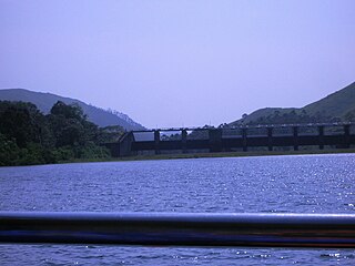
The Cheruthoni Dam, located in Idukki District, Kerala, India, is a 138m tall concrete gravity dam. Preliminary work on this project was initiated under the leadership of Superintending Engineer, E.U.Philipose. This dam was constructed in 1976 as part of the Idukki Hydroelectric Project along with two other dams Idukki and Kulamavu. The Canadian government aided the project with long-term loans and grants. The dam was constructed by HCC and the consultant was S.N.C. Inc., Canada,

Malankara dam is a gravity dam constructed across Muvattupuzha river for irrigation purposes. The dam is constructed to make use of the tail water from the Moolamattom power house. The project is run under the Muvattupuzha Valley Irrigation Project and KSEB. The artificial lake covers an area of around 11 square km.

Kulamavu Dam is a gravity/masonry dam on Kilivillithode, which is a tributary of the Periyar river in Arakkulam village, Idukki district in the Indian state of Kerala. It is one of three dams associated with the Idukki hydroelectric power project in the Indian state of Kerala. This dam is located towards the western side of the Idukki Arch Dam. This is a gravity dam with the top portion in concrete and the bottom in masonry.

The Lower Periyar Dam is a dam built on the Periyar River as part of the Lower Periyar Hydroelectric Project in Kanjikuzhi Panchayat, Idukki District, Kerala. The dam was built to generate electricity. The lower Periyar dam is at Pambla, five kilometres downstream from where Muthirapuzha merges with main river. This 32.36-metre-high dam made of concrete has a width of 284 meters. The powerhouse is at Karimanal, near Neriamangalam, where three generators are installed with a power production capacity of 60 MW each, or a cumulative 180 MW. The Dam was completed in the year 1998 Taluks through which release flow are Idukki, Kothamangalam, Muvattupuzha, Kunnathunadu, Aluva, Kodungalloor and Paravur.

Anayirangal Dam (Malayalam: ആനയിറങ്കൽ അണക്കെട്ട്) is an earthen dam built on the Panniyar river in Chinnakanal and Santhanpara panchayats, 22 km (14 mi) from Munnar in Idukki district of Kerala, India. The dam is surrounded on one side by forest and on the other by Tata Tea Plantation. The dam is located near the Munnar - Kumily road. The water flowing from the dam reaches Kuthungal and Ponmudi dams through the Panniyar river. Power is generated at Kuthungal and Panniyar powerhouses. The dam stores water from small streams flowing from Bealram and rainwater flowing from the hills on the Tamil Nadu border. The height of the dam is 34.14 metres (112.0 ft) and Length is 326.13 metres (1,070.0 ft). The reservoir usually fills up in June and July.
Azhutha Dam is a small diversion dam built on the Azhutha River which is a tributary of the Pamba River, at Azhutha in Peerumed Grama Panchayat of Idukki District, Kerala, India. It is a small concrete gravity dam that is only 72 metres (236 ft) long and 14 metres (46 ft) high. It acts mainly as a diversion dam to supply water to the Idukki Dam. The Azhutha Dam was constructed as an augmentation dam for the Idukki Hydro Electric Project. Construction of the project started in 1987 and was expected to be commissioned in 1991, but the project overrun and was only partially commissioned in June 1998. The year of completion was 2007. The release of the water from the dam is to Azhutha river and it flows through Ranni and Ayroor taluks.

Erattayar Dam is a small, diversion dam built on the Erattayar river in Erattayar grama panchayat near Kattappana town in Idukki district of Kerala, India. It acts mainly as a diversion dam to supply water to the Idukki dam. Diversion of water from Erattayar forebay to Idukki reservoir is through a tunnel called Anchuruli tunnel which is 3.77 km (2.34 mi) long. Construction of the dam was completed in the year 1989.

Kallar Dam is a small, diversion dam constructed at Perinjamkutty river in Nedumkandam grama panchayat of Idukki district, Kerala, India. It acts mainly as a diversion dam to supply water to the Idukki dam.

Kallarkutty Dam is a gravity dam built on the Muthirapuzha river, a tributary of the Periyar river, as part of the Neriamangalam Hydroelectric Project at Kallarkutty in Vellathooval panchayat of Idukki district in Kerala, India. The water discharged from the Chenkulam dam's powerhouse and the Muthirapuzha river is diverted to the Neriamangalam powerhouse near Panamkutty above the Pambla dam. The Hydroelectric Project was commissioned on 27 January 1961 to generate 45 MW of power using 3 turbines with a capacity of 15 MW. In 2006, the project was upgraded from 45 MW to 52.65 MW. Taluks through which release flow are Udumbanchola, Devikulam, Idukki, Kothamangalam, Muvattupuzha, Kunnathunadu, Aluva, Kodungalloor and Paravur. The Project was led by Kerala State Electricity Board Engineer E.U. Philipose
Narakakkanam Weir is a diversion dam constructed across Narakakkanam River in Mariyapuram panchayath of Thankamani Village in Idukki district in Kerala, India. Narakakkanam weir is an augmentation weir for the Idukki Hydro Electric Project. Narakakkanam, Azhutha, Vazhikkadavu, Vadakkepuzha and Kuttiar diversion schemes were later added to augment the Idukki reservoir. The height of the dam is 11.50 metres (37.7 ft) from the deepest foundation and length is 45.20 metres (148.3 ft).
Vadakkepuzha Weir is a diversion dam of Earthen type constructed across Vadakkepuzha which is a tributary of Muvattupuzha river in Arakkulam village in Idukki district of Kerala, India. Vadakkepuzha weir is a part of an augmentation scheme for the Idukki Hydro Electric Project. Narakakkanam, Azhutha, Vazhikkadavu, Vadakkepuzha and Kuttiar diversion schemes were later added to Idukki HEP to augment the reservoir. Water from the reservoir is pumped in to Idukki reservoir through a pump house with three pumps.
Kulamavu Saddle Dam (Near Junction) is one of the two saddle dams of Idukki Reservoir constructed across Kilivallithodu River which is a tributary of Periyar river at Arakkulam village in Idukki District of Kerala, India. It is a Rolled Earth filled dam with a height of 18.29 metres (60.0 ft) and a Length of 457.2 metres (1,500 ft). The road to Idukki from Thodupuzha passes over this saddle dam.


![Cheruthoni Junction,Idukki.cerrutoonni jNgkss[?],ittukki.jpg](http://upload.wikimedia.org/wikipedia/commons/thumb/d/d3/Cheruthoni_Junction%2CIdukki.%E0%B4%9A%E0%B5%86%E0%B4%B1%E0%B5%81%E0%B4%A4%E0%B5%8B%E0%B4%A3%E0%B4%BF_%E0%B4%9C%E0%B4%82%E0%B4%97%E0%B5%8D%E0%B4%95%E0%B5%8D%E0%B4%B7%E0%B5%BA%2C%E0%B4%87%E0%B4%9F%E0%B5%81%E0%B4%95%E0%B5%8D%E0%B4%95%E0%B4%BF.jpg/280px-Cheruthoni_Junction%2CIdukki.%E0%B4%9A%E0%B5%86%E0%B4%B1%E0%B5%81%E0%B4%A4%E0%B5%8B%E0%B4%A3%E0%B4%BF_%E0%B4%9C%E0%B4%82%E0%B4%97%E0%B5%8D%E0%B4%95%E0%B5%8D%E0%B4%B7%E0%B5%BA%2C%E0%B4%87%E0%B4%9F%E0%B5%81%E0%B4%95%E0%B5%8D%E0%B4%95%E0%B4%BF.jpg)

