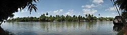
The Pamba River (also called Pampa River) is the third longest river in the Indian state of Kerala, after Periyar and Bharathappuzha, and the longest river in the erstwhile former princely state of Travancore. The Sabarimala Temple, dedicated to Lord Ayyappa, is located on the banks of the river Pamba.
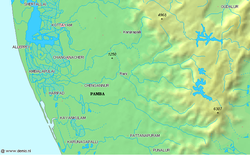
The Pamba originates at the Pulachimalai Hill in the Peerumedu Plateau in the Western Ghats at an altitude of 1,670 metres (5,480ft). Starting from the Idukki district and traversing a distance of 176 kilometres (109mi) through Pathanamthitta and Alappuzha districts, the river joins the Arabian Sea through a number of channels. Following its confluence with the Kakkiyar River it flows westwards until the Pamba is meet by the Arudhai Aar River. The Pamba heads south-east from Narayanamuzhi to the confluence of the Kakkattar River, whereafter it flows south to Vadasserikkara where it receives the Kallar River (Pamba).[1]
The Pamba basin extends over an area of 2,235 square kilometres (863sqmi) with the entire catchment area within Kerala state. The basin is bounded on the east by the Western Ghats and on the west by the Arabian Sea. The river shares its northern boundary with the Manimala River basin, and the southern boundary with the Achankovil River basin.[citation needed]
The Pamba basin - like all the river basins in Kerala - can be divided into three natural zones based on elevation, consisting of low land or seaboard, midland and high land. The coast for a short distance along the borders of lakes is flat, retreating from it the surface roughens up into slopes which gradually combine and swell into mountains on the east. The low land area along sea coast is generally swampy and liable to be flooded during monsoon inundation. The plains/midlands succeed low land in gentle ascents and valleys interspersed with isolated low hills. The high land on the eastern portion is broken by long spurs, dense forests, extensive ravines and tangled jungles. Towering above all their slopes are Western Ghats that form eastern boundary of the basins.[3]
Kuttanad is a river delta landscape region in Kerala known for its vast paddy fields and geographical peculiarities.[4] It is in the Districts of Alappuzha, Kottayam and Pathanamthitta. The region has the lowest altitude in India, and is one of the few places in the world where farming is carried on around 1.2 to 3.0 metres (4 to 10ft) below sea level,[5][6] using rice paddies largely located on reclaimed land amid the delta.[4] Kuttanad is historically important in the ancient history of South India and is the major rice producer in the state. Farmers of Kuttanad are famous for Biosaline Farming. The United Nations Food and Agriculture Organization (FAO) has declared the Kuttanad Farming System as a Globally Important Agricultural Heritage System (GIAHS) in 2013. Four of Kerala's major rivers, the Pamba, Meenachil, Achankovil and Manimala flow into the region.
Endangered state
Information board near Nadappanthal, Sabarimala to keep Pamba clean
Due to drought and a lack of conservation and protection by the government, the Pampa River has shrunk to a stream and is totally dry in many places. Nearby wells have also dried up. Water for farming, such as paddy fields, is scarce. Experts are calling for governmental awareness of the dire situation and the need to rein in development that is destroying the environment.[7]
The Kerala High Court has initiated steps to control the pollution of the river from the practice of some visitors to Sabarimala who throw their clothes into it.[8] As part of the Punyam Poonkavanam project, pilgrims have been exhorted to avoid the usage of soap and oil while bathing in River Pamba. They are also requested not to throw any material, including clothes, to this holy river. At a broader level, this project aims to spread the message of cleanliness and greenness beyond Pamba and Sabarimala.[9]
Significance in Hinduism
Pamba River near Sabarimala
Lord Ayyappan (Sri Dharmasastha) appeared to the Pandalam Raja as a child on the banks of the Pamba River. The Pamba River has been venerated as Ganga of kerala, and devotees of Lord Ayyappan believe that immersing oneself in the Pamba is equivalent to bathing in the Holy Ganges River. Bathing in the river, believed to absolve one's sins, is a requirement before commencing the trek through the forest to the Ayyappan Temple atop Sabarimala. Pamba is also referenced in the Valmiki Ramayana, where Rama visited the elderly devotee Sabari. This connection led to the mountain being named Sabarimala, meaning "mountain of Sabari."
This page is based on this Wikipedia article Text is available under the CC BY-SA 4.0 license; additional terms may apply. Images, videos and audio are available under their respective licenses.