
Ponmudi also known as Ooty of South Kerala, Kashmir of Kerala is a hill station in the Peringamala gramapanchayath of Trivandrum District of Kerala in India. It is located 22km west of Vithura town, 53 km north-east of Trivandrum City, 78 km south-east of Varkala town and 69 km north-east of Kovalam Beach at an altitude of 1,100 m (3,600 ft). Ponmudi (Varayadumotta) peak is a part of the Western Ghats mountain range that runs parallel to the Arabian Sea. Ponmudi is a popular honeymoon destination in South India. The normal temperature of Ponmudi is between 18 and 25 °C.

Periyar, IPA: [peɾijɐːr], is the longest river and the river with the largest discharge potential in the Indian state of Kerala. It is one of the few perennial rivers in the region and provides drinking water for several major towns. The Periyar is of utmost significance to the economy of Kerala. It generates a significant proportion of Kerala's electrical power via the Idukki Dam and flows along a region of industrial and commercial activity. The river also provides water for irrigation and domestic use throughout its course besides supporting a rich fishery. Due to these reasons, the river has been named the "Lifeline of Kerala". Kochi city, in the vicinity of the river mouth draws its water supply from Aluva, an upstream site sufficiently free of seawater intrusion. Twenty five percent of Kerala's industries are along the banks of river Periyar. These are mostly crowded within a stretch of 5 kilometres (3 mi) in the Eloor-Edayar region (Udhyogamandal), about 10 kilometres (6 mi) north of Kochi harbor.

Periyar National Park and Wildlife Sanctuary (PNP) is a protected area located in the districts of Idukki and Pathanamthitta in Kerala, India. It is notable as an elephant reserve and a tiger reserve. The protected area encompasses 925 km2 (357 sq mi), of which 305 km2 (118 sq mi) of the core zone was declared as the Periyar National Park in 1982. The park is a repository of rare, endemic, and endangered flora and fauna and forms the major watershed of two important rivers of Kerala: the Periyar and the Pamba.

Achankovil is a 128 km long west flowing river in Kerala, India, which flows through Kollam, Pathanamthitta, and Alappuzha districts. The river drains vast tract of fertile plains of Upper Kuttanad in the Alappuzha and Pathanamthitta districts. It also sustains numerous urban settlements along its course such as Konni, Pathanamthitta, Pandalam, Mavelikkara etc.

The Pamba River is the longest river in the Indian state of Kerala after Periyar and Bharathappuzha, and the longest river in the erstwhile former princely state of Travancore. Sabarimala temple dedicated to Lord Ayyappa is located on the banks of the river Pamba.

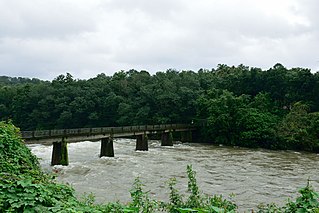
Vadaserikara is a village in Pathanamthitta district, in the state of Kerala, India. It is one of the 11 villages in Ranni and sits at the confluence of the Pamba and Kallar River.Nearest Railway Station Is Thiruvalla,Located At A Distance Of 34 km.The total geographical area of village is 6007 hectares.

Meenmutty Falls is a waterfall located 45 kilometres (28 mi) from Trivandrum city in Thiruvananthapuram District in the Indian state of Kerala, India. The falls are located near the Ponmudi hill station, Thiruvananthapuram district and Agastya Mala Biosphere reserves. This waterfalls is situated along the upper riparian course of Vamanapuram River.
Madatharuvi is a stream that joins the Pampa River in Ranni. It consist of a series of waterfalls and rapids that pass through pristine tropical forests. untouched by industries the water is pure and fresh with a few species of fresh water fish. It is near to Ranny city which the place is Mandamaruthi. From Mandamaruthi it is near 5 km. It is a small water stream with fresh water which is originating from forest, at last it will reach and join in Pamba River.

The Neyyar River is 56 km long river which flows through the Thiruvananthapuram district of Kerala in India. It flows from the Agastya Mala (Agastyarkoodam) in the Western Ghats. The town Neyyattinkara in Thiruvananthapuram district, is situated on the banks of the river, is named after this river. The river flows through the Neyyar wildlife sanctuary and into the Neyyar resorvoir. It then flows towards the west through the towns of Kallikkad, Kattakkada, Ottashekharamangalam, Keezharoor, Anavoor, Aruvipuram, Neyyantinkara and Thirupuram. The river then empties into the Arabian Sea at the Poovar estuary. Tributaries include the Kallar, Mullayar, and the Karavaliyar. It has several small canals along the river and the Neyyar Irrigation Project, "Neyyar Dam", is situated in this river. A safari park is located near the river. Neyyar river has been severely affected by sand mining.
Nedumudi is a village in the Alappuzha district of the Indian state of Kerala. It is the birthplace of Malayalam actor Nedumudi Venu. Nedumudi sits on the banks of the river Pamba. It was the first village in Kerala to attain 100% Literacy.

Veeyapuram is a village in the district of Alappuzha, Kerala, India. It is located about 7 kilometers north of Haripad town.
Koipuram is a large census village in Tiruvalla, Pathanamthitta district in the state of Kerala, India. Kumbanad, Muttumon, Pullad, Poovathoor, are the nodal points.
Manimala River or Manimalayar is a 92km long river which flows through South and Central Kerala. The river used to be wrongly considered as a tributary of Pamba River before satellite maps became popular, but this was proved incorrect. Manimala does not flow into the Pamba, instead a distributary of the Pamba river flows into the Manimala river at Kallunkal, later branches out again from Manimala at Nedumpuram and flows through Niranam, Thalavady, Edathua, Changankary, Champakulam, Nedumudy, Chennamkary, and finally Kainakary and then empties into the Vembanad lake. This branch again links with Manimala river at Chennankary in a short, but broad connection known as Munnattumukham.

Azhuthayar is a tributary of the Pamba River, the third longest river in the South Indian state of Kerala. It originates from Peerumedu, flows through dense forests and reaches Koruthodu. From there it forms the boundary between Kottayam and Idukki districts. It then crosses Sabarimala traditional trekking path at Kalaketti area before joining with Pamba river at Kanamala(Pambavalley). Like its parent river, it is also closely related to the legend of Lord Ayyappan, a popular Hindu deity worshipped mainly in Kerala. It flows through a place also named Azhutha, which is on the Sabarimala trek route from Erumeli to Sabarimala. The river Pamba, ultimately flows around 180 kilometres (112 mi) through towns and villages Ranni, Cherukolpuzha, Kozhencherry, Maramon, Aranmula, Chengannur, Parumala, Neerettupuram, Kavalam, Nedumudi and Thakazhy before joining Vembanad lake.

The Ranni Forest Division in Kerala, India, was constituted on 7 July 1958, comprising the Ranni, Vadasserikkara and Goodrical ranges, with its headquarters at Ranni. It covers the parts of Konni reserve forest and the reserves of Ranni, Goodrical, Rajampara, Karimkulam, Kumaramperoor, Valiyakavu, and Schettakkal. It covers an area of 1,059 square kilometres (409 sq mi).

Kakki Dam is a dam built on the Kaki River, a tributary of the Pampa River in the Ranni Forest in the Seethathodu Grama Panchayat, Pathanamthitta District, Kerala. The dam is located in a forested area adjacent to the Periyar National Park. It was built in 1966 as part of the Sabarigiri Hydroelectric Project. The water sources of the dam are from the Pampa Dam and the Kaki River. The sabarigiri project envisaged creation of two reservoirs which are Pamba and Kakki reservoirs and connecting these together to form a single source of water. The water from Pamba reservoir is connected to the Kakki reservoir through an underground tunnel of length 3.21 km. The intake of the Sabarigiri Powerhouse is from Kakki reservoir. The dam is 336 metres (1,102 ft) long and 116 metres (381 ft) high and is located at an elevation of 981.45 metres (3,220.0 ft) above sea level. The release flows through Ranni, Konni, Kozhencherry, Thiruvalla, Chengannur, Kuttanadu, Mavelikara and Karthikappally taluks before emptying into the Vembanad Lake,

Viripara Weir is a Diversion weir constructed across Upper Kallar river which is a tributary of Pooyankutty river in Mankulam village of Idukki district in Kerala, India. The water flows from the dam to Menachery river and flows through the taluk of Devikulam. The Viripara weir is constructed as an augmentation scheme to Neriamangalam Hydro Electric Project. Upper Kallar, a tributary of Pooyankutty river is diverted in to Kallarkutty reservoir by a low diversion weir at Viripara along with a short diversion tunnel.
Gavi Dam or Gaviar Dam is a small, gravity dam constructed as a part of Sabarigiri hydro electric project on Gaviyar, which is a tributary of Pamba river at Seethathode village in Pathanamthitta district of Kerala, India. Taluks through which release flow are Ranni, Konni, Kozhencherry, Thiruvalla, Chengannur, Kuttanadu, Mavelikara and Karthikappally.

Kochu Pamba Weir is a diversion dam constructed across Pamba river in Seethathode village of Pathanamthitta district in Kerala, India. It is one of the five dams which are parts of Sabarigiri HydroElectric Project. These are Pamba dam, Kakki dam, Anathode dam, Gavi dam and Kochu Pamba weir Sabarigiri Hydro Electric Project is the second largest hydro electric project of Kerala and is located in Pathanamthitta district. This weir is constructed as a part of Sabarigiri Augmentation Scheme. Water from this reservoir is pumped in to the Pamba reservoir through a pump house located at the downstream of Pamba dam. Taluks through which release flow are Ranni, Konni, Kozhencherry, Thiruvalla, Chengannur, Kuttanadu, Mavelikara and Karthikappally.


