
Pathanamthitta District, is one of the 14 districts in the Indian state of Kerala. The district headquarters is in the town of Pathanamthitta. There are four municipalities in Pathanamthitta: Adoor, Pandalam, Pathanamthitta and Thiruvalla.

Ponmudi is a hill station in the Peringamala gramapanchayath of Thiruvananthapuram district of Kerala in India. It is located 22km west of Vithura town, 53 km north-east of Thiruvananthapuram City, 78 km south-east of Varkala town and 69 km north-east of Kovalam Beach at an altitude of 1,100 m (3,600 ft). Ponmudi (Varayadumotta) peak is a part of the Western Ghats mountain range that runs parallel to the Arabian Sea. Ponmudi is a popular honeymoon destination in South India. The normal temperature of Ponmudi is between 18 and 25 °C .The lowest temperature in Ponmudi ever recorded is 8°C.

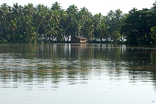
Kettuvallam is a houseboat widely used in the Indian state of Kerala. These have thatched roof covers over wooden hulls. The traditional kettuvallam is mainly used for promoting Kerala tourism.
Karamana is a river flowing through the city of Thiruvananthapuram in Kerala, India. The river starts near the southern tip of the Western Ghats(Sahyadri Mountains) at Agastyar Koodam. The river flows 66 km westward and merges with the Arabian Sea at Panathura near Kovalam. The river gets its name from Karamana, a suburb of Thiruvananthapuram city, through which it flows.

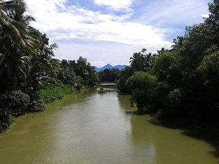
Achankovil is a 128 km (80 mi) long west flowing river in Kerala, India. It flows through the districts of Kollam, Pathanamthitta and Alappuzha. The river drains vast tract of fertile plains of Upper Kuttanad in the Alappuzha and Pathanamthitta districts. It also sustains numerous urban settlements along its course such as Konni, Pathanamthitta, Pandalam and Mavelikkara.

Pathanamthitta, is a municipality situated in the Southern Kerala, India, spread over an area of 23.50 km2. It is the administrative capital of Pathanamthitta district. The town has a population of 37,538. The Hindu pilgrim centre Sabarimala is situated in the Pathanamthitta district; as the main transport hub to Sabarimala, the town is known as the 'Pilgrim Capital of Kerala'. Pathanamthitta District, the thirteenth revenue district of the State of Kerala, was formed with effect from 1 November 1982, with headquarters at Pathanamthitta. Forest covers more than half of the total area of the District. Pathanamthitta District ranks the 7th in area in the State. The district has its borders with Allepey, Kottayam, Kollam and Idukki districts of Kerala and Tamil Nadu. Nearest town is Thiruvalla, located at a distance of 30 km. Thiruvalla railway station is 30 km via Thiruvalla-Kumbazha highway.

Konni, also spelt Konny, is a town and taluk headquarters in Pathanamthitta district of Kerala, India. Konni is known for its elephant cages, forests, and rubber plantations. It is also known as "Aanakoodinte Nadu". Nearest town is Pathanamthitta. Konni is located 32 km (20 mi) from Chengannur railway station and NH 183 in Chengannur. It is well-connected via Muvattupuzha - Punalur state highway. Buses ply frequently from Pathanamthitta KSRTC bus station to Konni.

Meenmutty Falls is a waterfall located 45 kilometres (28 mi) from Trivandrum city in Thiruvananthapuram District in the Indian state of Kerala, India. The falls are located near the Ponmudi hill station, Thiruvananthapuram district and Agastya Mala Biosphere reserves. This waterfalls is situated along the upper riparian course of Vamanapuram River.

Kumarakom Bird Sanctuary is situated at Kumarakom in Kottayam taluk of Kottayam district in the Indian state of Kerala, on the banks of Vembanad Lake. Set in the Kerala Backwaters, the bird sanctuary is visited by many migratory bird species.
The Neyyar River is 56 km long river which flows through the Thiruvananthapuram district of Kerala in India. It flows from the Agastya Mala (Agastyarkoodam) in the Western Ghats. The town Neyyattinkara in Thiruvananthapuram district, is situated on the banks of the river, is named after this river. The river flows through the Neyyar wildlife sanctuary and into the Neyyar resorvoir. It then flows towards the west through the towns of Kallikkad, Kattakkada, Ottashekharamangalam, Keezharoor, Anavoor, Aruvipuram, Neyyantinkara and Thirupuram. The river then empties into the Arabian Sea at the Poovar estuary. Tributaries include the Kallar, Mullayar, and the Karavaliyar. It has several small canals along the river and the Neyyar Irrigation Project, "Neyyar Dam", is situated in this river. A safari park is located near the river. Neyyar river has been severely affected by sand mining.
Thannithode is a village in Pathanamthitta district in the state of Kerala, India. It is near Konni town and is mainly a plantation township. The famous Adavi eco-tourism is situated in Thannithode.

Vallicode-Kottayam is a village in Pathanamthitta district in the state of Kerala, India. Vallicode-Kottayam village is a part of Konni Taluk, District of Kerala State, India.

Vamanapuram River is an 88 km (55 mi) long river in southern Kerala that flows through the northern parts of Thiruvananthapuram district. It is also the longest river in Thiruvananthapuram district. The river is also known as "Kollampuzhayaru" and "Attingalaru".The two tributaries of this river are the Upper Chittar & Manjaprayaar streams which originates near Ponmudi hill station.

Angamoozhy is a village in Pathanamthitta district in the Indian state of Kerala. Angamoozhy is located near the Kakkad power station and the Sabarimala temple. Geographically Angamoozhy is High-range area.

Kallar is a perennial tributary of Pamba river, the third longest river in the South Indian state of Kerala. Kallar originates in the forests of Ranni reserve in the eastern part of Pathanamthitta district. As the name implies, the river bed is mostly stony. It flows its entire length through rich forests before merging with Pamba at Vadasserikkara. Small villages such as Thannithode, Thekkuthode and Manneera are the major human settlements along the banks of this river. Kallar is the main component of Adavi eco-tourism project at Mannera in the Konni forest division where it offers an opportunity for coracle riding along a three kilometer stretch. The river supports rich diversity of plants and animals.

Pandalam dynasty a royal dynasty emerged from a branch of Pandya kingdom. which existed in Kerala during the Kollam era. They came to Kerala fearing the assault of the Nayaks of Madurai. In Kerala they were given land and status by Kaipuzha Thampan of Nilambur Kovilakam a landlord who lived in Amanthur Palace at Kaipuzha from Kottayam Kerala. Today Pandalam is part of Pathanamthitta, Kerala, India.
Government Medical College in Konni, Pathanamthitta is the seventh government medical college in Kerala.

Perunthenaruvi Project is a tourism and hydroelectric power project at Perunthenaruvi near Vechoochira in Ranni, Kerala, India. The Kerala Tourism Development Corporation has launched the Perunthenaruvi tourism project as part of the eco-tourism chain linking Achankovil, Gavi, Konni and Ranni.

Perunthenaruvi Weir is a diversion dam built across Pamba river at villages of Naranammoozhy and Vechoochira in Pathanamthitta District of Kerala, India. Perumthenaruvi Small Hydroelectric Project 6 MW (2×3) is a run-of-the-river scheme in river Pamba, and the weir is a part of this scheme. This envisages the utilization of water from 442 km2 (171 sq mi) catchment of Pamba and Azhutha river for electricity generation under a net head of 18.00 m. The power house is located on the left bank of Pamba river. The weir is a concrete gravity type with a height of 10.93 metres (35.9 ft) and a length of 227.50 metres (746.4 ft). Taluks through which the release flow are Ranni, Konni, Kozhencherry, Thiruvalla, Chengannur, Kuttanadu, Mavelikara and Karthikappally.
The Konni Forest Division is located in Kerala, India, and covers an area of about 331.66 square kilometres (128.05 sq mi). It is the first reserve forest in Kerala, which was declared on 9 October 1888 under the Travancore Forest Act of 1887. The division is part of the Western Ghats, which were designated as a UNESCO World Heritage Site in 1 July 2012. The forest area is a repository of many endemic species of the Western Ghats.


