Related Research Articles
The Gatun Dam is an earthen dam across the Chagres River in Panama, near the town of Gatun. The dam, constructed between 1907 and 1913, is a crucial element of the Panama Canal; it impounds the artificial Gatun Lake, which carries ships 33 kilometres (21 mi) of their transit across the Isthmus of Panama. In addition, a hydro-electric generating station at the dam generates electricity which is used to operate the locks and other equipment in the canal.

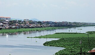
The Kerala backwaters are a network of brackish lagoons and canals lying parallel to the Arabian Sea of the Malabar coast of Kerala state in south-western India. It also includes interconnected lakes, rivers, and inlets, a labyrinthine system formed by more than 900 km (560 mi) of waterways, and sometimes compared to bayous. The network includes five large lakes linked by canals, both man made and natural, fed by 38 rivers, and extending virtually half the length of Kerala state. The backwaters were formed by the action of waves and shore currents creating low barrier islands across the mouths of the many rivers flowing down from the Western Ghats range. In the midst of this landscape there are a number of towns and cities, which serve as the starting and end points of backwater cruises. There are 34 backwaters in Kerala. Out of it, 27 are located either closer to Arabian Sea or parallel to the sea. The remaining 7 are inland navigation routes.

Table Rock Lake is an artificial lake or reservoir in the Ozarks of southwestern Missouri and northwestern Arkansas in the United States. Designed, built and operated by the U.S. Army Corps of Engineers, the lake is impounded by Table Rock Dam, which was constructed from 1954 to 1958 on the White River.

Kuttanad is a region covering the Alappuzha, Kottayam and Pathanamthitta Districts, in the state of Kerala, India, well known for its vast paddy fields and geographical peculiarities. The region has the lowest altitude in India, and is one of the few places in the world where farming is carried on around 1.2 to 3.0 metres below sea level. Kuttanad is historically important in the ancient history of South India and is the major rice producer in the state. Farmers of Kuttanad are famous for Biosaline Farming. Food and Agriculture Organization (FAO) has declared the Kuttanad Farming System as a Globally Important Agricultural Heritage System (GIAHS) in 2013.
Topi is a town in the eastern part of the Swabi District of Khyber Pakhtunkhwa province of Pakistan. The administrative division of Topi unfolds into two Union councils: Topi East and Topi West. Notably, the Tarbela Dam, largest earth-filled dam in the world, is located only 9 kilometres (5.6 mi) east of Topi.

The Pamba River is the longest river in the Indian state of Kerala after Periyar and Bharathappuzha, and the longest river in the erstwhile former princely state of Travancore. The Sabarimala Temple, dedicated to Lord Ayyappa, is located on the banks of the river Pamba.

Tuttle Creek Lake is a reservoir on the Big Blue River 5 miles (8 km) north of Manhattan, in the Flint Hills region of northeast Kansas. It was built and is operated by the Army Corps of Engineers for the primary purpose of flood control. Secondary functions of the project include release of water stores to maintain barge traffic on the Mississippi River during seasons of drought, maintenance of a multi-use conservation pool for fish and wildlife enhancement and recreation, and release of sufficient water in droughts to maintain water quality for downstream communities.
The Temenggor Dam or Temenggor Hydro-Electric Project or Temenggor Power Station is a dam in Gerik, Perak, Malaysia. It is located on Perak River about 200 km northeast of Ipoh. Construction of the dam impounded Temenggor Lake.
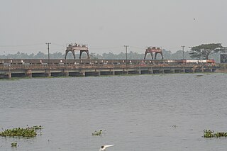
The Thanneermukkom Bund was constructed as a part of the Kuttanad Development Scheme to prevent tidal action and intrusion of salt water into the Kuttanad low-lands across Vembanad Lake between Thannermukkom on west and Vechur on east. Thanneermukkom Bund was constructed in 1974 and is functional since 1976. It is the largest mud regulator in India. This barrier essentially divides the lake into two parts - one with brackish water perennially and the other half with fresh water fed by the rivers draining into the lake.

Spring Creek Debris Dam is an earthfill dam on Spring Creek, a tributary of the Sacramento River, in Shasta County in the U.S. state of California. Completed in 1963, the dam, maintained by the U.S. Bureau of Reclamation, serves primarily to collect severe acid mine drainage stemming from the Iron Mountain Mine. The dam forms the Spring Creek Reservoir, less than 1 mile (1.6 km) long. Spring Creek and South Fork Spring Creek flow into the reservoir from a 16-square-mile (41 km2) watershed. The dam is directly upstream from the city of Keswick, California and the Keswick Reservoir. The operation is part of the Trinity River Division of the Central Valley Project.
The Manggahan Floodway is an artificially constructed waterway in Metro Manila, Philippines. The floodway was built in 1986, with the cost of 1.1 billion pesos, in order to reduce flooding along the Pasig River during the rainy season, by diverting the peak water flows of the Marikina River to Laguna de Bay, which serves as a temporary reservoir. In case the water level on the lake is higher than the Marikina River, the floodway can also reverse the flow.

The Cotter Dam is a concrete gravity and rockfill embankment dam across the Cotter River, located in the Australian Capital Territory, Australia. Both the dam and river are named after early settler in the area Garrett Cotter. The impounded Cotter Reservoir is a supply source of potable water for the city of Canberra and its environs.
Manimala River, or Manimalayar, is a 92km long river which flows through South and Central Kerala. The river used to be wrongly considered as a tributary of Pamba River before satellite maps became popular, but this was proved incorrect. Manimala does not flow into the Pamba, instead a distributary of the Pamba river flows into the Manimala river at Kallunkal, later branches out again from Manimala at Nedumpuram and flows through Niranam, Thalavady, Edathua, Changankary, Champakulam, Nedumudy, Chennamkary, and finally Kainakary and then empties into the Vembanad lake. This branch again links with the Manimala River at Chennankary in a short, but broad connection known as Munnattumukham.

Jiroft Dam is a hydroelectric dam in Iran with an installed electricity generating capability of 85 MWh situated in Kerman Province. The fifth concrete dam built in the country, it was begun in 1975 and completed in 1992. It is located on Halil River (Halilrood) 40 km upstream of Jiroft in the narrow valley of Narab. Its reservoir capacity is around 410 million cubic metres up to the normal level. The maximum height of the dam is 134 m and the crest length is 277 m. The dam in its first water year of operation (1992) survived an extraordinary flood with the peak discharge of 5035 cubic metres per second. The flood had a return period of 800 to 1000 years. The heavy rains of this year caused the dam was filled of water much sooner than the planned water storing duration. The spillways and other hydrodynamic outlets of the dam can manage to discharge up to 6500 cubic meters per seconds . The reservoir is planned to irrigate 14200 hectares of the downstream lands.

The Polavaram Project is an under construction multi-purpose irrigation project on the Godavari River in the Eluru District and East Godavari District in Andhra Pradesh. The project has been accorded National project status by the Central Government of India. Its reservoir back water spreads up to the Dummugudem Anicut and approx 115 km on Sabari River side. Thus back water spreads into parts of Chhattisgarh and Odisha States. It gives major boost to tourism sector in Godavari Districts as the reservoir covers the famous Papikonda National Park, Polavaram hydro electric project (HEP) and National Waterway 4 are under construction on left side of the river. It is located 40 km to the upstream of Sir Arthur Cotton Barrage in Rajamahendravaram City and 25 km from Rajahmundry Airport.
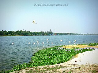
Thottappally is a village in Alappuzha district in the state of Kerala, India. Thottappally is especially notable for Thottappally Spillway, a spillway cum bridge on the National Highway 66 between Alappuzha and Thiruvananthapuram. The spillway is one of the two regulators used to regulate waterlevel in the paddy fields of Kuttanad, the other being at Thanneermukkom. Thottappally is Kuttanad's drain-way-out to the Arabian Sea. The Thottappally Spillway splits the Thottappally lake with the fresh water part to the east and saline Thottappally rivermouth to the west merging with the Arabian Sea. The beach and fishing harbour of Purakkad, which got into fame through the celebrated film and novel Chemmeen, is adjacent to Thottappally.

Nacimiento Dam is a dam on the Nacimiento River about 10 miles (16 km) northwest of Paso Robles, California in the United States. The primary purpose of the dam is to provide groundwater recharge for agriculture in Monterey County and northern San Luis Obispo County supported by the Salinas Valley aquifer, as well as flood control, domestic water supply, and hydropower. It forms Lake Nacimiento, popular for boating, fishing and camping, and known locally as the "Dragon Lake" due to its shape.

The Vorotan Cascade, or the ContourGlobal Hydro Cascade, is a cascade on the Vorotan River in Syunik Province, Armenia. It was built to produce hydroelectric power and provide irrigation water. The Vorotan Cascade consists of three hydroelectric power plants and five reservoirs with a combined installed capacity of 404.2 MW. It is one of the main power generation complexes in Armenia.

The Kanjirapuzha Dam, a masonry earth dam built for providing irrigation to a Cultural Command Area (CCA) of 9,713 hectares, is located in the Palakkad district in the Indian state of Kerala. The reservoir, which has three islands within it, also has an established commercial fisheries development programme operated by the Fisheries Department.
Meenkara Dam is an embankment or earthen dam built on the banks of the river Gayatripuzha, a tributary of the river Bharathapuzha, at Muthalamada in the Muthalamada Grama Panchayat near Kollengode in the Palakkad district of Kerala with masonry spillway sections. It is part of the Gayatri Irrigation Project. The project was started in 1956 and partially commissioned in 1960. The project was fully completed in 1964. The irrigation scheme has been prepared for agriculture and drinking water in Palakkad district. Farms in Chittoor, Nemmara, Alathur in Palakkad district and Vadakkancherry in Thrissur district will benefit from this irrigation scheme.
References
- ↑ "Thottappally spillway opened to prevent flooding in Kuttanad". OnManorama. Retrieved 8 July 2021.
- ↑ Kuttanad 1992, Kerala Sasthrasahithya Parishat (publisher)