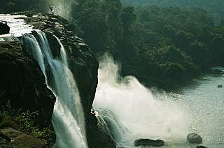
Athirapally Falls is situated in the border of Kuttampuzha Panchayat in Aluva Taluk, of Ernakulam District and Athirapilly Panchayat in Chalakudy Taluk of Thrissur District in Kerala, India on the Chalakudy River, which originates from the upper reaches of the Western Ghats at the entrance to the Sholayar ranges. It is the largest waterfall in Kerala, which stands tall at 81.5 feet. Just a short drive from Athirapilly is the Vazhachal Falls, which is close to dense green forests that are home to many endangered and endemic species of flora and fauna.
The roads from main road to athirapally water falls are very natural fresh air atmosphere. Specially Morning and late evening There is another waterfall on the way from Athirapilly to Vazhachal Falls, in close proximity to the road, which is locally called "Charpa Falls". Athiramppally Falls is the largest waterfall in Kerala and is nicknamed "The Niagara of South India".[1]
Controversy about a state-proposed hydroelectric dam on the Chalakudy River above the waterfalls began in the 1990s and continued through 2017.
River
View of Athirappilly Falls from below
The 145 kilometres (90mi) long Chalakudy River, originates in the Anaimalai mountains of the Western Ghats[2] and flows through the Vazhachal Forest toward the Arabian Sea. The river starts off smooth but becomes more turbulent as it nears Athirapilly. At Athirappilly Falls, the water surges around big rocks and cascades down in three separate plumes. Below the falls, the river remains turbulent for about 1 kilometre (0.62mi) until it reaches Kannamkuzhi, from where it calms and flows smoothly until reaching the dam at Thumpoormuzhi.[citation needed]
Plantations in the area contain teak, bamboo, and eucalyptus. Environmentalists claim that Athirappilly is a one-of-its-kind riparian ecosystem in Kerala. V.S. Vijayan, Chairman of the Kerala State Biodiversity Board and former Director of the Salim Ali Centre for Ornithology and Natural History (SACON), Coimbatore, has been quoted in Down to Earth magazine as affirming that the Vazhachal forest division is the second most biodiverse area in the State. The International Bird Association has declared it an ‘Important Bird Area' and the Asian Nature Conservation Foundation has recommended that the area should be declared a sanctuary or a national park, he points out. The Wildlife Trust of India says it represents one of India's best elephant conservation efforts. "Any disruption to this fragile ecosystem will spell disaster," says Vijayan.[3] The river provides a habitat for 85 species of freshwater fishes. Among these, 35 are endemic species.[citation needed]
Tourism
View from the nearest allowed pointDuring rainy seasonView of Athirappilly waterfalls from belowThe lushy green forests of Western Ghats surrounding the Athirapally Waterfalls after the monsoon rains.
The railway station nearest to Athirappilly Falls, 30kilometres(19mi) to the west, is Chalakkudy Railway Station, and the nearest airport is Cochin International Airport, about 55kilometres(34mi) southwest of the waterfall and 58kilometres(36mi) south of city of Thrissur.[4] Athirappilly is easily reachable from Chalakkudy by taxi or by bus from the Chalakkudy bus terminal. Athirappilly is situated on a state highway connecting Tamil Nadu and Kerala, in a thick forest and so night travel is not permitted. The checkpoints at either end close by 6:30 pm IST prior to which all vehicles have to exit through either checkpoint.
The journey from Chalakkudy to the Athirappilly Falls passes through a landscape of winding roads, small villages and lush green trees. Visitors can reach the top of the waterfall via a paved path that leads through thick bamboo clusters. From Angamaly, the route is in the midst of an Oil Palm Reserve at Ezhattumugham tourism village. A steep narrow path or a wide staired path can be taken to the bottom of the falls. The falls attract visitors from across India, especially during the monsoon months (June–September). About 7 million tourists visit the falls and the Vazhachal picnic spot each year.[5]
Jungle safari
Daily jungle safari trips are organized by Thrissur District Tourism Promotion Council with Athirappilly Destination Management Council from Chalakudy to Malakkappara.
A major portion of the 1986 Tamil movie Punnagai Mannan was shot near the falls, the falls itself playing a role in it. It made the falls so popular in Tamil Nadu that it got the nickname "Punnagai Mannan Falls".
The song "Koyaliya Gati Hai Payaliya Chhankati Hai" from the film "Jungle Love" in 1990
The falls are also famous as a site location for "Narumugaye Narumugaye", a song from the Tamil filmIruvar, acted by Mohanlal and actress Aishwarya Rai.
This waterfall is also a major location for songs like "Behne De" and most scenes in the Hindi film Raavan and Tamil film Raavanan.
The song "Adada Mazhaida" from Paiyaa featuring Karthi and Tamannaah was shot in this location.
In 1994, the Kerala State Electricity Board (KSEB) proposed a 163-megawatt Athirappilly Hydro Electric Project. It was to include a dam 23metres(75ft) high and 311metres(1,020ft) wide on the Chalakudy River in the Vazhachal Forest Division about 5kilometres(3mi) upstream of Athirappilly Falls and 400metres(1,312ft) upstream of Vazhachal Rapids (Vazhachal Falls).[6] However, environmental groups and people's collectives opposed the project on grounds that it would damage the environment, infringe on human rights, and threaten tourism.[7] Though it was not their main concern, critics also noted that if the entire course of the river were diverted to make electricity, the Athirappilly-Vazhachal waterfalls could dry up. To avoid damaging the falls, the KSEB proposed adjusting the water releases to maintain the falls.[8] The debate continued in 2007. Environmentalists also expressed concern over whether the proposed hydroelectric project at Athirappilly waterfalls would lead to displacement and eventual extinction of the primitive tribal group, 'Kadars,' in the area.[9]
In 2005, the Kerala Ministry of Environment and Forests approved the project on the basis of a report by Water and Power Consultancy Services (India) Ltd. (WAPCOS), an environmental impact assessment (EIA) agency. In 2006, the Kerala High Court quashed the clearance and ordered another public hearing.[10][11] The debate continued for the following years.
On 29 January 2011, the chairman of the Western Ghats Ecology Expert Panel (WGEEP) Madhav Gadgil opined that the Environment Impact Assessment (EIA) of the Athirappilly hydel power project was not properly carried out and 70% of it is bogus. The panel, appointed by the Union Ministry of Environment and Forests, was asked to look into and give recommendations on various projects in the Western Ghats such as the hydroelectric projects in Gundiya in Karnataka and Athirappilly in Kerala and the overall development projects in Ratnagiri and Sindhudurg districts of Maharashtra. Gadgil said that the proposed Athirappilly hydro-electric project cannot be approved until the Forest Rights Act is implemented in its true spirit for the Kadar tribal community of the area and also no comprehensive study had been carried out so far on the natural riparian forest vegetation along the Western Ghats.[12][13][14] On 14 June 2011, Union Minister for Environment and Forests Jairam Ramesh said his ministry would not approve the Athirappilly hydroelectric project.[15] The minister also stated, “When states are denied such projects on larger and long-term environmental considerations, they are entitled to some sort of green bonus."[16] The first part of the WGEEP report was submitted to the Ministry on 31 August. The Western Ghats Ecology Expert Panel (WGEEP), on 6 September 2011 recommended to the Union Ministry of Environment and Forests against granting permission to carry out any construction activities at the sensitive Athirappilly-Vazhachal region. The panel, which submitted its report to Union Environment Minister Jayanti Natarajan in the capital, named Athirappilly as one of the 18 eco-sensitive localities (ESL) in the state.[17] But K. Radhakrishnan, a former member (generation), of KSEB, has opined that this panel report was highly biased with vested interests and the project was eco-friendly doing minimum damage to the environment and forests because KSEB itself has its own vested interests if the Dam Project takes life.[18][19][20] While there are reports from renowned experts from the Kerala State Biodiversity Board that the power project would adversely affect the ecology of the area and the estimated power output would be dependable upon the rainfall and dry summer seasons, which is undependable in its own way. M. Sivasankar, a KSEB chairman and MD states the need of more environment-friendly power projects with lower operating costs and higher output like supercritical boiler plants.
Periyar, is the longest river and the river with the largest discharge potential in the Indian state of Kerala. It is one of the few perennial rivers in the region and provides drinking water for several major towns. The Periyar is of utmost significance to the economy of Kerala. It generates a significant proportion of Kerala's electrical power via the Idukki Dam and flows along a region of industrial and commercial activity. The river also provides water for irrigation and domestic use throughout its course besides supporting a rich fishery. Due to these reasons, the river has been named the "Lifeline of Kerala". Kochi city, in the vicinity of the river mouth, draws its water supply from Aluva, an upstream site sufficiently free of seawater intrusion. Twenty five percent of Kerala's industries are along the banks of the Periyar. These are mostly crowded within a stretch of 5 kilometres (3 mi) in the Eloor-Edayar region (Udhyogamandal), about 10 kilometres (6 mi) north of Kochi harbor.
Chalakudy is a municipal town situated on the banks of Chalakudy River in Thrissur district of the Kerala state in India. It is the headquarters of Chalakudy taluk. It is the base camp for travellers to Athirappilly Falls and Vazhachal Falls. Chalakudy lies on National Highway 544 and located about 47 km (23 mi) north of the city of Kochi, and 30 km (19 mi) south of Thrissur.
Chalakudy River or Chalakudy Puzha is the fifth longest river in Kerala, India. The river flows through Thrissur district, Palakkad district and Ernakulam district of Kerala. The total drainage area of the river is 1704 km2. Out of this, 1404 km2 lies in Kerala and the rest in Tamil Nadu. The length of the river is 145.5 km. Though Chalakudy River in strict geological sense is a tributary of the Periyar river, for all practical purposes it is treated as a separate river by Government and other agencies. The river has gained its name since it flows along the banks of the Chalakudy Town, the major settlement along the course of the river. It is perhaps the most unpolluted and pristine river in the state and even in India due to the limited amount of industries and wastage disposal around it. Chalakudy River and its basin area were one of the most affected rivers during the 2018 Kerala floods.
Thrissur, anglicised as Trichur, is one of the 14 districts in the Indian state of Kerala. It is situated in the central region of the state. Spanning an area of about 3,032 km2 (1,171 sq mi), the district is home to over 9% of Kerala's population.
Vazhachal Falls is situated in Athirappilly Panchayath of Thrissur district in Kerala on the southwest coast of India. Located on the west-flowing Chalakudy River near the Vazhachal Forest Division and at the edge of the Sholayar ranges, it is just 5 km from entrance of Athirappilly Falls. It is located 36 km from Chalakudy.
Raavan is a 2010 Indian Hindi-language epic action-adventure film co-written and directed by Mani Ratnam, who also co-produced the film. It stars Abhishek Bachchan, Aishwarya Rai Bachchan, and Vikram while Govinda, Nikhil Dwivedi, Ravi Kishan, and Priyamani are in pivotal roles. It marks the Hindi film debuts of Vikram and Priyamani. The film follows the crux of the epic Ramayana, but with a modernized plot that reveals the perspective of Ravana.
Madhav Dhananjaya Gadgil is an Indian ecologist, academic, writer, columnist and the founder of the Centre for Ecological Sciences, a research forum under the aegis of the Indian Institute of Science. He is a former member of the Scientific Advisory Council to the Prime Minister of India and the Head of the Western Ghats Ecology Expert Panel (WGEEP) of 2010, popularly known as the Gadgil Commission.
Athirappilly is a first grade Grama Panchayath with 489.00 km2 area in Chalakudy Taluk, Thrissur district in Kerala, India. It is located 60 km from Thrissur city, 70 km northeast of Kochi city, 55 km northeast of Cochin International Airport, and 30 km from Chalakudy town.
Madhu Balakrishnan is an Indian playback singer who primarily sings in Malayalam. He has also sung songs in Tamil, Telugu, Kannada languages. He has sung over 10 thousand songs in films and several devotional albums.
Kunnisseri Veettil Raman Mani, better known by his stage name Kalabhavan Mani, was an Indian actor and singer. Mani started his career as a mimicry artist with the Kalabhavan comedy troupe. He had starred in over 250 films, including Malayalam, Tamil, Kannada, and Telugu films, and was renowned for his humorous characters and villain roles.
Sholayar Dam is a concrete dam built across the Chalakkudi River in Malakkappara in Thrissur district, Kerala of India. The dam consists of main Sholayar Dam, Sholayar Flanking and Sholayar Saddle Dam. It also contains Sholayar Hydro Electric Power Project of KSEB who owns the dam. Total installed capacity of the project is 54MW with 3 penstock pipes. The maximum storage capacity is 2663 feet. Sholayar is 65 km from Chalakudy town. The dam above Sholayar dam is Upper Solaiyar Dam owned by Tamil Nadu.
Potta is a tiny village 30 miles north of Kochi, also known as Cochin. It belongs to the municipality of Chalakudy in the Thrissur district, state of Kerala, India. Potta was the temple land under the Irinjalakuda Koodalmanikyam Temple. In the past, the crops needed to supply the temple were cultivated at Potta. The village features famous temples named Pambambot temple, the Parakottilinkal Bhagavathi Temple and the Mathilthkavu Bhagavathi Temple. It also houses a Christian church called Cherupushpam Shrine. Also, several educational institutions could be found there including Panampilly Memorial Government College, Vyasa Vidyaniketan Central School, Kuriakos Chavara UP School and Dhanya Mission Hospital.
State Highway 21 or Chalakkudy-Malakkappara Road is a State Highway in Kerala, India that starts in Chalakudy and ends at the state boundary with Tamil Nadu at Malakkappara. The road where its majority of portion passes through Sholayar reservoir is 86.0 kilometres (53.4 mi) long. It passes through one of the most picturesque rainforests and is often described as one of the best scenic routes in India. The Athirappilly falls and Vazhachal falls are located on this route. It connects with Valparai-Pollachi Road in Tamil Nadu.
Malakkappara or Malakhappara is a small hill station in Thrissur district of the state of Kerala, India. This place is situated on the border between Kerala and Tamil Nadu.
Charpa Falls is a waterfall located in Athirappilly panchayath in Thrissur district of Kerala. Located on the west-flowing Chalakudy River, this waterfall lies in between the more famous Athirappilly Falls and Vazhachal Falls. It is a popular stopover for tourists who are visiting the Athirappilly and Vazhachal Falls. It is located close to the road, and during monsoon months, the water splashes onto the road. During the dry season, the water stops flowing.
Pattathippara Falls is a cascade waterfall located in Pananchery Grama Panchayat in Thrissur district of Kerala, India. The entry into waterfalls area is blocked since it is inside the reserve forest. Unauthorized entry will attract imprisonment 1 to 5 years and up to ₹5000 as fine. The waterfall is three-tiered but appears in rainy seasons as a single fall.
"Dhivara" is a Telugu song from the soundtrack of the 2015 film Baahubali: The Beginning. Sung by Ramya Behara and Deepu, the song was composed by M.M. Keeravani with lyrics penned by Ramajogayya Sastry. Most of the lyrics of the song were written in Sanskrit.
Odiyan (transl. Shapeshifter) is a 2018 Indian Malayalam-language fantasy drama film directed by V. A. Shrikumar Menon in his feature film debut. The film was written by Harikrishnan and is based on the legend of the Odiyan clan, who in Kerala folklore are men believed to possess shapeshifting abilities and can assume animal forms. Odiyans are said to have inhabited the Malabar region of Kerala before the widespread use of electricity. The film stars Mohanlal in the title role, alongside an ensemble cast of Prakash Raj, Manju Warrier, Siddique, Innocent, Manoj Joshi, Sana Althaf, Kailesh, Narain, Sreejaya Nair and Nandhu Krishnamoorthy. It was produced by Antony Perumbavoor through Aashirvad Cinemas. Manikyan, a notorious Odiyan, returns to his village after an exile of 15 years to see his lover once, including his friends, Damodharan and more over, Manikyan's girlfriend Prabha. His arrival causes much unease to some of the villagers, especially Ravunni Nair, Prabha's cousin brother, who has a personal grudge against him.
Nyctibatrachus athirappillyensis is a frog in the genus Nyctibatrachus. It was described in 2017 based on specimens collected in Thavalakuzhipara, Vazhachal forest and is named after the nearby Athirappilly waterfalls.
This page is based on this Wikipedia article Text is available under the CC BY-SA 4.0 license; additional terms may apply. Images, videos and audio are available under their respective licenses.