Sholayar Dam

Last updated
Sholayar Dam
Lower sholayar dam.jpg
Sholayar Dam
Official nameSholayar hydro electric project
Location Malakkappara, Thrissur India 20px
Coordinates 10°19′18″N76°44′07″E / 10.32167°N 76.73528°E / 10.32167; 76.73528
PurposeElectricity
Opening date1965
Operator(s) KSEB
Dam and spillways
ImpoundsSholayar Chalakkudy River
Height56 m (184 ft)
Length430.53 m (1,412 ft)
Spillway capacity1825 M3/Sec
Reservoir
Creates Lower Sholayar Reservoir
Total capacity153,600,000 cubic metres (5.42×10⁹ cu ft) (5.42 tmcft)
Active capacity150,200,000 cubic metres (5.30×10⁹ cu ft) (5.31 tmcft)
Surface area8.705 hectares (21.51 acres)
Power Station
Operator(s) KSEB
Commission date1961
Turbines 3 x 18 Megawatt (Francis-type)
Installed capacity 54 MW
Annual generation 233 MU
Sholayar Power House

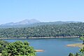
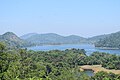
Sholayar Dam is a concrete dam built across the Chalakkudi River in Malakkappara in Thrissur district, Kerala of India. [1] [2] The dam consists of main Sholayar Dam, Sholayar Flanking and Sholayar Saddle Dam. It also contains Sholayar Hydro Electric Power Project of KSEB who owns the dam. Total installed capacity of the project is 54MW with 3 penstock pipes. [3] The maximum storage capacity is 2663 feet. [4] Sholayar is 65 km from Chalakudy town. [5] The dam above Sholayar dam was Upper Solaiyar Dam owned by Tamil Nadu.

Contents

History

Sholayar Dam, Sholayar Saddle Dam and Sholayar Flanking dam are commissioned in 1965. The reservoir has an area of 8.705 square km and the length of the dam is 430.60 metres. The Sholayar Dam has a height of 66 metres and 430 metres width, [6] Sholayar Flanking Dam has a height of 18 metres from the foundation with 109 metres length [7] and Sholayar Saddle has a height of 259 metres and 109 metres width.

Related Research Articles

<span class="mw-page-title-main">Daman Ganga River</span> River in western India

The Daman Ganga also called Dawan River is a river in western India. The river's headwaters are on the western slope of the Western Ghats range, and it flows west into the Arabian Sea. The river flows through Maharashtra and Gujarat states, as well as the Union territory of Dadra and Nagar Haveli and Daman and Diu. The industrial towns of Vapi, Dadra and Silvassa lie on the north bank of the river, and the town of Daman occupies both banks of the river's estuary.

<span class="mw-page-title-main">Periyar River</span> River in Kerala, India

Periyar, IPA:[peɾijɐːr], is the longest river and the river with the largest discharge potential in the Indian state of Kerala. It is one of the few perennial rivers in the region and provides drinking water for several major towns. The Periyar is of utmost significance to the economy of Kerala. It generates a significant proportion of Kerala's electrical power via the Idukki Dam and flows along a region of industrial and commercial activity. The river also provides water for irrigation and domestic use throughout its course besides supporting a rich fishery. Due to these reasons, the river has been named the "Lifeline of Kerala". Kochi city, in the vicinity of the river mouth draws its water supply from Aluva, an upstream site sufficiently free of seawater intrusion. Twenty five percent of Kerala's industries are along the banks of river Periyar. These are mostly crowded within a stretch of 5 kilometres (3 mi) in the Eloor-Edayar region (Udhyogamandal), about 10 kilometres (6 mi) north of Kochi harbor.

<span class="mw-page-title-main">Banasura Sagar Dam</span> Dam in Wayanad, Kerala

Banasura Sagar Dam, which impounds the Karamanathodu tributary of the Kabini River, is part of the Indian Banasurasagar Project consisting of a dam and a canal project started in 1979. The goal of the project is to support the Kakkayam Hydro electric power project and satisfy the demand for irrigation and drinking water in a region known to have water shortages in seasonal dry periods. The dam is also known as Kuttiyadi Augmentation Main Earthen Dam. The dam has a height of 38.5 metres (126 ft) and length of 685 metres (2,247 ft).

<span class="mw-page-title-main">Perunchani Dam</span> Dam in Tamil Nadu, India

Perunchani Dam is an irrigation dam at Perunchani, in Kalkulam Taluk, Kanyakumari District, in the state of Tamil Nadu, India. It is one of the dams of the Kodayar Irrigation System. As there was water deficiency in the Kodayar Irrigation System, Perunchani Dam was constructed in December 1952 to store flood water of the Paralayar River as an extension. It was built about 1 km (0.62 mi) upstream of the Puthen dam on the Paralayar River. The irrigation system became operational on 2 September 1953. It feeds the left bank irrigation canal system of the Puthen dam, which is the terminal structure of the system.

Solaiyar Dam Dam in Tamil Nadu, India

Upper Solaiyar or Upper Sholayar Dam is located 20 km (12 mi) from Valparai, a hill station in the Anaimalai Hills of the Coimbatore district, Tamil Nadu India. As it is a part of the hydroelectric project of Tamil Nadu, special permission is required to visit the dam.

<span class="mw-page-title-main">Ponmudi Dam</span> Dam in Kerala, India

The Ponmudi Dam is a concrete gravity dam built across the Panniyar river which is a tributary of Periyar river at Konnathady panchayath of Konnathadi village in Idukki district of Kerala, India. The dam was constructed in 1963 as a part of a hydroelectric project. Construction was led by E.U.Philipose, Superintending Engineer, Kerala State Electricity Board. It has a length of 288.80 metres (947.5 ft). The hydropower component of the dam has an installed capacity of 30 MW with firm power of 17 MW, generating 158 GWh annually. Taluks through which the river flow are Udumbanchola, Devikulam, Kothamangalam, Muvattupuzha, Kunnathunadu, Aluva, Kodungalloor and Paravur.

<span class="mw-page-title-main">Pazhassi Dam</span> Dam in Kerala, India

The Pazhassi Dam also called Kulur Barrage is a stone masonry diversion structure in Kannur district, Kerala, India. It is named after king Pazhassi Raja, a patriot who died a heroic death in the war. The dam is constructed across the west flowing Bavali river near Veliyambra. It was commissioned by Prime Minister Morarji Desai in 1979. It mainly functions as an irrigation dam, serving a command area of 11,525 hectares in Iritty taluk of the Kannur District. The water from this dam also meets the drinking water requirement of Kannur district. The dam site and the reservoir are famous for their scenic beauty.

<span class="mw-page-title-main">Kanjirapuzha Dam</span> Dam in Kerala, India

The Kanjirapuzha Dam, a masonry earth dam built for providing irrigation to a Cultural Command Area (CCA) of 9,713 hectares, is located in the Palakkad district in the Indian state of Kerala. The reservoir, which has three islands within it, also has an established commercial fisheries development programme operated by the Fisheries Department.

<span class="mw-page-title-main">Kakki dam</span> Dam in Kerala, India

Kakki Dam is a concrete gravity dam built on the Kakki river, a tributary of the Pampa river in the Ranni forest in the Seethathodu panchayat of Pathanamthitta district in Kerala, India. The dam is located in a forested area adjacent to the Periyar National Park. It was built in 1966 as part of the Sabarigiri Hydroelectric Project. The water sources of the dam are from the Pampa dam and the Kakki river. The Sabarigiri project envisaged creation of two reservoirs which are Pamba and Kakki reservoirs and connecting these together to form a single source of water. The water from Pamba reservoir is connected to the Kakki reservoir through an underground tunnel of length 3.21 km. The intake of the Sabarigiri Powerhouse is from Kakki reservoir. The dam is 336 metres (1,102 ft) long and 116 metres (381 ft) high and is located at an elevation of 981.45 metres (3,220.0 ft) above sea level. The release flows through Ranni, Konni, Kozhencherry, Thiruvalla, Chengannur, Kuttanadu, Mavelikara and Karthikappally taluks before emptying into the Vembanad lake.

<span class="mw-page-title-main">Peruvannamuzhi Dam</span> Dam

Peruvannamuzhi dam, also known as Kuttiady (Id) Dam, is a dam built on the Kuttiady River at Peruvannamuzhi in Chakkittapara Grama Panchayath in Kozhikode district, Kerala. It is 16 km away from Kuttiady town and it is 55 km from Kozhikode town. It was constructed as part of the Kuttiady irrigation project. The project consists of a masonry dam across Kuttiyady River and 13 earth dams to maximize the storage of the reservoir. The construction of this project started in 1962 and was commissioned in 1973.

<span class="mw-page-title-main">Pambla Dam</span> A dam in Kerala, India

The Lower Periyar Dam is a dam built on the Periyar River as part of the Lower Periyar Hydroelectric Project in Kanjikuzhi Panchayat, Idukki District, Kerala. The dam was built to generate electricity. The lower Periyar dam is at Pambla, five kilometres downstream from where Muthirapuzha merges with main river. This 32.36-metre-high dam made of concrete has a width of 284 meters. The powerhouse is at Karimanal, near Neriamangalam, where three generators are installed with a power production capacity of 60 MW each, or a cumulative 180 MW. The Dam was completed in the year 1998 Taluks through which release flow are Idukki, Kothamangalam, Muvattupuzha, Kunnathunadu, Aluva, Kodungalloor and Paravur.

<span class="mw-page-title-main">Pamba Dam</span> Dam in Kerala, India

Pamba Dam is a gravity dam built on the Pamba river in the Ranni forest area of Seethathodu panchayat in Pathanamthitta district of Kerala, India. It was built in 1967 as part of the Sabarigiri Hydroelectric Project. Sabarigiri Hydro Electric Project (IHEP) is the second largest hydro electric project in Kerala. Pamba dam's reservoir is connected to the nearby Kakki dam's reservoir by a 3.21 km (1.99 mi) long underground tunnel. The dam is 281 m (922 ft) long and 57.2 m (188 ft) high and is located at an elevation of 981.45 m (3,220.0 ft) above sea level. The dam is located in a forest area adjacent to the Periyar National Park. The water stored in the Pamba and Kakki dams is conveyed to the Sabarigiri powerhouse through penstock pipes. The dam was commissioned in 1967.

<span class="mw-page-title-main">Chenkulam Dam</span> Dam in Kerala, India

Chenkulam Dam is a gravity dam located on the Muthirapuzha river in Vellathooval panchayat of Idukki district in the Indian state of Kerala. It spans 144.50 metres (474.1 ft) long and stands 26.82 metres (88.0 ft). It hosts a 48 MW power plant.

Meenkara Dam is an embankment or earthen dam built on the banks of the river Gayatripuzha, a tributary of the river Bharathapuzha, at Muthalamada in the Muthalamada Grama Panchayat near Kollengode in the Palakkad district of Kerala with masonry spillway sections. It is part of the Gayatri Irrigation Project. The project was started in 1956 and partially commissioned in 1960. The project was fully completed in 1964. The irrigation scheme has been prepared for agriculture and drinking water in Palakkad district. Farms in Chittoor, Nemmara, Alathur in Palakkad district and Vadakkancherry in Thrissur district will benefit from this irrigation scheme.

<span class="mw-page-title-main">Kullar Dam</span> Diversion dam in Kerala, India

Kullar Dam is a small, flanking dam which impounds Kullar river in Seethathodu village of Pathanamthitta district in Kerala, India. The dam was built as a part of Sabarigiri Hydroelectric Project. The release from the dam flows to Pamba river and from there, it flows through Ranni, Konni, Kozhencherry, Thiruvalla, Chengannur, Kuttanadu, Mavelikara and Karthikappally taluks.

<span class="mw-page-title-main">Veluthodu Dam</span> Diversion dam in Kerala, India

Veluthodu dam is a part of Kakkad Hydro Electric Project and is located in Seethathode panchayath of Ranni Taluk in Pathanamthitta District of Kerala, India. Its a Concrete-Gravity dam built across the Veluthodu river, a tributary of Kakkad River which is again a tributary of Pamba River The dam is built primarily for electricity. This diversion dam diverts water to the water conductor system from Moozhiyar reservoir to Kakkad Power Station. This power station utilises the tail race water from Sabarigiri power station and flow received from moozhiyar and velluthode rivers. After power generation, water from Kakkad power station is released to the Kakkad River. Taluks through which release flow are Ranni, Konni, Kozhencherry, Thiruvalla, Chengannur, Kuttanadu, Mavelikara and Karthikappally It is operated by Kerala State Electricity Board.

<span class="mw-page-title-main">Upper Moozhiyar Dam</span> A diversion dam in Kerala, India

Upper moozhiyar dam is an Earthen Dam constructed across Moozhiyar River in Seethathodu village of Pathanamthitta district in Kerala, India. This dam was constructed as a part of Sabarigiri Augmentation Scheme. The stream is located in southern side of Kakki reservoir. It is an embankment structure. Sabarigiri Hydro Electric Project is the second largest hydro electric project of Kerala and is located in Pathanamthitta district. This dam is constructed for diverting the upper reaches of Moozhiyar river, a tributory of Pamba river to the Kakki -Anathode reservoir through a tunnel. The surplus over the storage flows over the rock cut spillway to Moozhiyar river. Taluks through which release flow are Ranni, Konni, Kozhencherry, Thiruvalla, Chengannur, Kuttanadu, Mavelikara, and Karthikappally. Nearest city is Vandiperiyar.

<span class="mw-page-title-main">Kuttiyadi saddle dam</span> A concrete dam in Kerala

Kuttiyadi Saddle Dam is a concrete gravity dam built across Karamanathodu river which is a tributary of Kabani river in Padinjarathara village of Wayanad district in Kerala, India. It is one of the six dams created as part of Kuttiyadi Augmentation scheme which augments the Banasurasagar reservoir. The dam was built and is maintained by Kerala State Electricity Board.

<span class="mw-page-title-main">Nayanmoola Saddle Dam</span> An earthen dam in Kerala

Nayanmoola Saddle dam is an earthen dam constructed across Karamanthode at Thariyode village of Wayanad district in Kerala, India. It is a saddle dam of Banasura sagar reservoir built as a part of the Kuttiyadi Augmentation scheme. The dam has a height of 3.5 metres (11 ft) and a length of 24.0 metres (78.7 ft)

Kulamavu Saddle Dam (Near Junction) is one of the two saddle dams of Idukki Reservoir constructed across Kilivallithodu River which is a tributary of Periyar river at Arakkulam village in Idukki District of Kerala, India. It is a Rolled Earth filled dam with a height of 18.29 metres (60.0 ft) and a Length of 457.2 metres (1,500 ft). The road to Idukki from Thodupuzha passes over this saddle dam.

References

  1. "Dams in West flowing rivers from Tadri to Kanyakumari Basin". Water Resources Information System- Wiki. Retrieved 2021-03-18.
  2. "SHOLAYAR DAM – K TNPWD Limted Dam Safety Organisation" . Retrieved 2021-03-18.
  3. "West Flowing Rivers from Tadri to Kanyakumari" (PDF).
  4. "Parambikulam, Sholayar dams reaching maximum capacity, orange alert issued". Mathrubhumi. 15 September 2019. Retrieved 2021-03-18.
  5. "Fact File on Major Dams owned by Kerala State Electricity Board". Expert Eyes. Retrieved 2013-06-27.
  6. "Dams in West flowing rivers from Tadri to Kanyakumari Basin". Water Resources Information System- Wiki. Retrieved 2021-03-18.
  7. "Dams in West flowing rivers from Tadri to Kanyakumari Basin". Water Resources Information System- Wiki. Retrieved 2021-03-18.

See also