Idamalayar Dam

Last updated

Idamalayar Dam
Idamalayar Dam.jpg
Idamalayar Dam
India relief location map.jpg
Red pog.svg
Location of Idamalayar Dam in India
India Kerala relief map.svg
Red pog.svg
Idamalayar Dam (Kerala)
Official nameIdamalayar Dam
Country India
Location Ernakulam District, Kerala
Coordinates 10°12′53.0″N76°52′37.4″E / 10.214722°N 76.877056°E / 10.214722; 76.877056 10°12'53.0"N 76°52'37.4"E
Construction began1970
Opening date1985
Construction costRs. 539.50 crores (US$1.199 billion)
Owner(s) Kerala State Electricity Board
Dam and spillways
Type of dam Gravity dam
Impounds Edamalayar/Periyar river
Height102.80 metres (337.3 ft)
Length373 metres (1,224 ft)
Reservoir
CreatesIdamalayar Reservoir
Total capacity1.0898 cubic kilometres (0.2615 cu mi)
Catchment area 381 km2 (147 sq mi)
Surface area28.3 km2 (10.9 sq mi)
Operator(s)Kerala State Electricity Board
Turbines 2 x 37.5 MW
Installed capacity 75 MW
Annual generation 380  GW·h

Idamalayar Dam is a multipurpose concrete gravity dam located at Ennakkal between Ayyampuzha and Bhoothathankettu in Ernakulam district of Kerala on the Idamalayar, a tributary of the Periyar River in Kerala, South India. The dam however extends east as far as Malakkappara. Completed in 1985, with a length of 373 metres (1,224 ft) and a height of 102.8 metres (337 ft), the dam created a multipurpose reservoir covering 28.3 km2 (10.9 sq mi) in the scenic hills of the Anamalais. [1] [2]

Contents

The reservoir storage is utilized by a hydroelectric power station which has an installed capacity of 75 MW with two units of 37.5 MW capacity, producing an annual energy output of 380 GW·h. [3] [4]

The large reservoir created by the Idamalayar Dam is operated by the Kerala State Electricity Board to augment its peak power generation requirements. [5] The dam will benefit the Idamalayar Irrigation Development Project by diverting water released from the tail race channel of the Idamalayar power station. [6]

Geography

The Idamalayar Dam is located on the Idamalayar River, a tributary of the Periyar River in Kerala. Edamalayar originates in the Anamala Hills in Ernakulam district itself at elevation of 2,520 metres (8,270 ft). The river is a perennial source draining a catchment area of 381 km2 (147 sq mi) with a topography of high relief. The catchment receives annual rainfall of 6,000 millimetres (240 in), 90% of which occurs during the monsoon months of June to September. [5]

The dam is located 81 kilometres (50 mi) from Ernakulam in Ernakulam district and 10–12 kilometres (6.2–7.5 mi) from the Bhoothathankettu dam (literal meaning in Malayalam language: "monster dam") on the Periyar River, which takes its name from local myths attributing its construction to demons who built it with the intention of submerging Thrikkariyoor temple. [7]

Reservoir area where birds are spotted IndamalayarReservoir View.JPG
Reservoir area where birds are spotted
Idamalayar Dam
Dams in Periyar Basin

Water resources

Based on detailed hydrological analysis, with observed data supplemented by rainfall-runoff correlation and prediction of low flows during dry months, the mean annual runoff was estimated as about 1,207 million cubic meters (million cubic metres) and that at 95% availability as 730 million cubic metres. Therefore, the live storage in the reservoir was fixed at 1,032.3 million cubic metres. However, subsequent to the commissioning of the project in 1987, availability of the flows was reassessed. It was noted that flows reduced to 1,178 million cubic metres in dry season and reached 4,361 million cubic metres during the monsoon. The total annual flow was assessed as 5,539 million cubic metres. As irrigation requirements are not critical during monsoon season the assessment of dry weather flows is relevant for irrigation. [5]

Further, Idamalayar storage is being supplemented from diversion of flows from the Peringalkuthu Reservoir during the monsoon season through the Vachumaram diversion canal constructed during 1997. The water stored in the reservoir is used for energy generation during the monsoon season by adopting a suitable reservoir operational schedule so that the water diverted from the diversion canal is not spilled out. [8]

Structural details

Idamalayar dam Idamalayar dam side view.jpg
Idamalayar dam

The dam built across the Idamalayar River is a gravity concrete structure with a total height of 102.80 metres (337.3 ft) above the deepest foundation level with a length of 373 metres (1,224 ft) at the crest level. The full reservoir level is elevation 169 metres (554 ft) [4] and the minimum draw down level (MDDL) is 115 metres (377 ft). The dam has created a reservoir with a water spread of 28.3 km2 (10.9 sq mi). The reservoir has a gross storage capacity of 1,089.0 million cubic metres of which the effective storage is 1,017.8 million cubic metres. The spillway has been designed to pass a design flood discharge of 3,012.8 cubic metres per second (106,400 cu ft/s). [1] [4]

The storage in the reservoir created behind the high concrete gravity dam is utilized for power generation by diversion through a water conductor system comprising a 1,700 metres (5,600 ft) long power tunnel, surge shaft and two lines of penstocks connected to the turbines installed in a surface power station for generation of 75 MW of power with two units of 37.5 MW capacity each. [9]

Instrumentation is provided in the Idamalayar Dam and the observations carried out are analysed regularly to monitor the safety of the structure. However, a rehabilitation project envisaging improving the safety and operational performance of selected structures such as dams, barrages and regulators, which covers 19 projects under the Irrigation Department and 12 projects of the Kerala State Electricity Board, has been approved under the World Bank funded "Dam Rehabilitation and Improvement Project (DRIP)" to be implemented from January 2011. Idamalayar Dam is one of the projects included in this programme. However, the rehabilitation work on this dam is proposed to be taken up in the second stage. [10] [11]

Power Generation

Idamalayar project is a low head Hydro Electric Scheme located in Ernakulam District. The power house is situated downstreams of the dam. Installed capacity of the Project is 75 MW. It is in the fifth position in Kerala in terms of Installed capacity. There is a power tunnel of 1,700 metres (5,600 ft) length from where 2 penstock pipes takes the water to the power house. Two generators of 37.5 MW capacity produce the electricity. The units were commissioned in 1987 February. They generate 380 Million Units of power annually. There are two feeders from this Power house. First one is to Chalakudy and to Madakkathara from there and the second one is to Malayattur, perumbavur and joins the power grid in Kalamassery. [12]

Irrigation benefits

Upstream view of the dam from the reservoir Upstream view of Idamalayar Dam.JPG
Upstream view of the dam from the reservoir

Irrigation benefits from the water stored in the Idamalayar Reservoir are proposed by utilizing the tail-race water released from the Idamalayar Power house. For this purpose, the project titled "The Idamalayar Irrigation Project" is under implementation. Under this project, the tail race discharge from the Idamalayar powerhouse is picked up at the barrage constructed across the Periyar River at Bhoothathankettu and diverted through a canal system on the right bank of the barrage. The irrigation benefits envisaged covers an area of 14,394 hectares (35,570 acres) of wet and dry agricultural lands, out of which the cultivable command area is 13,209 hectares (32,640 acres). The project is under implementation since 1981. The cost of the project was initially Rs 18.5 crores (about US$411.11 million), which as per latest reports of 2007 is stated to be Rs. 539.50 crores (US$1198.9 million). According to the Annual Plan 2010–2011 of the State Government, substantial work of the main canal, the low level canal and the link canal still needs to be completed to derive full planned benefits of irrigation. [13] [14]

Apart from power and irrigation benefits, the project situated in scenic forest area also provides recreational benefits of boating in the reservoir, bird watching and trekking. [15]

Construction delays

The Idamalayar Dam project was started in 1970 and completed after 17 years. In an analysis carried out in 2001 on the reasons for the delay in completion of Hydropower Projects resulting in immense cost overruns in Kerala, it was noted that the Idamalayar project could be commissioned only in 1987 with a time overrun of 9 years and consequent cost overrun of 285% resulting in a capital cost of Rs 2.81 per kWh of generation. While technical reasons for the delays were fully documented, the delay highlighted, however, was attributed to the "irrational behaviour of the organized militant labour". [16] A High Level Committee set up by the Government of Kerala, which examined this issue, observed that the Idamalayar Dam project has been the "victim of recurring and long inertial periods of labour unrest". [16]

There was also controversy over the contract awards. The government appointed Justice K. Sukumaran to inquire into allegations related to the Idamalayar and Kallada dam construction contracts. Based on his report, Minister R. Balakrishna Pillai and others were prosecuted by a Special Court. [17] The Kerala high court later acquitted them, but in February 2011 the Supreme Court of India sentenced R. Balakrishna Pillai and two others to a year in prison for abusing their positions when awarding the contracts. [18]

Birds

In the reservoir area of the Idamalayar Dam, several species of birds have been reported. The reservoir and surrounding areas are very rich in bamboo. The birds found are: heart-spotted woodpecker, common flameback, black rumped flameback, greater flameback, crimson-fronted barbet, Malabar grey hornbill, Malabar trogon, dollarbird, Oriental dwarf kingfisher, stork-billed kingfisher, common hawk cuckoo, plum-headed parakeet, Malabar parakeet, white-rumped needletail, brown-backed needletail, jungle owlet, green imperial pigeon, emerald dove, grey-fronted green pigeon, river tern, brahminy kite, hornbill, grey-headed fish eagle, black eagle, Oriental honey buzzard, rufous-bellied hawk-eagle, little heron, Asian openbill, fairy bluebird, small minivet, bar-winged flycatcher-shrike, black-naped monarch, Asian paradise flycatcher, Malabar whistling thrush, rusty-tailed flycatcher, white-bellied blue-flycatcher, Indian blue robin, chestnut-tailed starling, velvet-fronted nuthatch, great tit, dusky crag martin, red-rumped swallow, Asian koel, yellow-browed bulbul, Wayanad laughingthrush, dark-fronted babbler, rufous babbler, Nilgiri pipit, yellow-billed babbler, brown-cheeked fulvetta, plain flowerpecker, crimson-backed sunbird, and little spiderhunter. [19] white bellied wood pecker

Related Research Articles

<span class="mw-page-title-main">Bhakra Dam</span> Dam in Himachal Pradesh, India

Bhakra Nangal Dam is a concrete gravity dam on the Satluj River in Bhakra Village near Bilaspur in Bilaspur district, Himachal Pradesh in northern India. The dam forms the Gobind Sagar reservoir.

<span class="mw-page-title-main">Periyar River</span> River in Kerala, India

Periyar, IPA:[peɾijɐːr], is the longest river and the river with the largest discharge potential in the Indian state of Kerala. It is one of the few perennial rivers in the region and provides drinking water for several major towns. The Periyar is of utmost significance to the economy of Kerala. It generates a significant proportion of Kerala's electrical power via the Idukki Dam and flows along a region of industrial and commercial activity. The river also provides water for irrigation and domestic use throughout its course besides supporting a rich fishery. Due to these reasons, the river has been named the "Lifeline of Kerala". Kochi city, in the vicinity of the river mouth draws its water supply from Aluva, an upstream site sufficiently free of seawater intrusion. Twenty five percent of Kerala's industries are along the banks of river Periyar. These are mostly crowded within a stretch of 5 kilometres (3 mi) in the Eloor-Edayar region (Udhyogamandal), about 10 kilometres (6 mi) north of Kochi harbor.

<span class="mw-page-title-main">Tarbela Dam</span> Dam in Khyber Pakhtunkhwa, Pakistan

Tarbela Dam is an earth-filled dam along the Indus River in Pakistan's Khyber Pakhtunkhwa province. It is located mainly in the Haripur District of the province. It is about 20 km (10 mi) from the city of Haripur, 105 km (65 mi) northwest of Islamabad, and 125 km (80 mi) east of Peshawar. It is the largest earth-filled dam in the world. The dam is 143 metres (470 ft) high above the riverbed and its reservoir, Tarbela Lake, has a surface area of approximately 250 square kilometres (97 sq mi).

<span class="mw-page-title-main">Idukki Dam</span> Dam in Idukki, Kerala

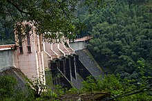
The Idukki Dam is a double curvature arch dam constructed across the Periyar River in a narrow gorge between two granite hills locally known as Kuravan and Kurathi in Idukki, Kerala, India. At 168.91 metres (554.2 ft), it is one of the highest arch dams in Asia. It is constructed and owned by the Kerala State Electricity Board. It supports a 780 MW hydroelectric power station in Moolamattom, which started generating power on 4 October 1975. The dam type is a concrete, double curvature parabolic, thin arc dam. The Indo-Canadian project was inaugurated by the Prime Minister Indira Gandhi on February 17, 1976.

<span class="mw-page-title-main">Gandhi Sagar Dam</span> Dam in Mandsaur District Madhya Pradesh

GandhisagarDam is situated at a distance of 168 km from the District headquarter. The Dam is constructed on the Chambal River.

<span class="mw-page-title-main">Nagarjuna Sagar Dam</span> Dam in Andhra Pradesh & Nalgonda district, Telangana

Nagarjuna Sagar Dam is a masonry dam across the Krishna River at Nagarjuna Sagar which straddles the border between Palnadu district in Andhra Pradesh and Nalgonda district in Telangana. The dam provides irrigation water to the districts of Palnadu, Guntur, Nalgonda, Prakasam, Khammam, Krishna, and parts of West Godavari. It is also a source of electricity generation for the national grid.

<span class="mw-page-title-main">Srisailam Dam</span> Dam in Andhra Pradesh and Telangana, India

The Srisailam Dam is constructed across the Krishna River in Nandyal district, Andhra Pradesh and Nagarkurnool district, Telangana near Srisailam temple town and is the 2nd largest capacity working hydroelectric station in India.

<span class="mw-page-title-main">Malampuzha Dam</span> Dam in Palakkad District, Kerala

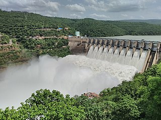
Malampuzha Dam is the second largest dam and reservoirs in Kerala, located near Palakkad, in the state of Kerala in South India, built post independence by the then Madras state. Situated in the scenic hills of the Western Ghats in the background it is a combination of a masonry dam with a length of 1,849 metres and an earthen dam with a length of 220 metres making it the longest dam in the state. The dam is 355 feet high and crosses the Malampuzha River, a tributary of Bharathappuzha, Kerala's second longest river. There is a network of two canal systems that serve the dam's reservoir of 42,090 hectares.

<span class="mw-page-title-main">Dahla Dam</span> Dam in Kandahar Province, Afghanistan

The Dahla Dam, also known as Arghandab Dam and Kasa, is located in the Shah Wali Kot District of Kandahar Province in Afghanistan, approximately 40 kilometres (25 mi) north of the provincial capital Kandahar. Constructed in 1952, it is said to be the second largest dam in Afghanistan. As of 2019, the Afghan government is spending $450 million on making the dam more useful. The project includes raising the dam's walls by 12 meters so its reservoir can hold nearly a billion cubic meters of fresh water and installing three turbines for the production of 22 megawatts (MW) of electricity.

<span class="mw-page-title-main">Interbasin transfer</span>

Interbasin transfer or transbasin diversion are terms used to describe man-made conveyance schemes which move water from one river basin where it is available, to another basin where water is less available or could be utilized better for human development. The purpose of such water resource engineering schemes can be to alleviate water shortages in the receiving basin, to generate electricity, or both. Rarely, as in the case of the Glory River which diverted water from the Tigris to Euphrates River in modern Iraq, interbasin transfers have been undertaken for political purposes. While ancient water supply examples exist, the first modern developments were undertaken in the 19th century in Australia, India and the United States, feeding large cities such as Denver and Los Angeles. Since the 20th century many more similar projects have followed in other countries, including Israel and China, and contributions to the Green Revolution in India and hydropower development in Canada.

<span class="mw-page-title-main">Ponmudi Dam</span> Dam in Kerala, India

The Ponmudi Dam is a concrete gravity dam built across the Panniyar river which is a tributary of Periyar river at Konnathady panchayath of Konnathadi village in Idukki district of Kerala, India. The dam was constructed in 1963 as a part of a hydroelectric project. Construction was led by E.U.Philipose, Superintending Engineer, Kerala State Electricity Board. It has a length of 288.80 metres (947.5 ft). The hydropower component of the dam has an installed capacity of 30 MW with firm power of 17 MW, generating 158 GWh annually. Taluks through which the river flow are Udumbanchola, Devikulam, Kothamangalam, Muvattupuzha, Kunnathunadu, Aluva, Kodungalloor and Paravur.

<span class="mw-page-title-main">Upper Wardha Dam</span> Dam in Maharashtra, India

The Upper Wardha Dam is an earthfill straight gravity dam across the Wardha River, a tributary of the Godavari River, near Simbhora village in Morshi taluk in Amravati district in the Indian state of Maharashtra. The dam provides multipurpose benefits of irrigation, drinking water supply, flood control and hydropower generation.

<span class="mw-page-title-main">Bhadra Dam</span> Dam in Karnataka, India

The Bhadra Dam or Lakkavalli Dam, which has created the Bhadra Reservoir, is located on the Bhadra River a tributary of Tungabhadra River. Bhadra Dam is located in the border of Bhadravathi and Tarikere, in the western part of Karnataka in India. The benefits derived from the reservoir storage are irrigation with gross irrigation potential of 162,818 hectares, hydro power generation of 39.2 MW, drinking water supply and industrial use. The dam commissioned in 1965 is a composite earth cum masonry structure of 59.13 metres (194.0 ft) height with length of 1,708 metres (5,604 ft) at the crest level, which submerges a land area of 11,250.88 hectares.

Lakhwar-Vyasi Dam project on Yamuna River, includes under-construction Lakhwar Dam and Power Station, Vyasi Dam, Hathiari Power Station and Katapathar Barrage, near the Lakhwar town in Kalsi block of Dehradun district of Uttarakhand in India, for the purpose of irrigation of 40,000 hectare land and total 927 MW hydroelectric power generation. "Lakhwar Dam" is a gravity dam near the Lohari village with 300MW power generation capacity. "Vyasi Dam" will be built 5 km downstream along with 120 MW "Hathiari Power Station" further 0.5 km downstream. "Katapathar Barrage", with the maximum ponding water level at 514.5m elevation, will be built further 2.75 km downstream of the Hathiari Power Station to supply the water to stakeholder states. Project will hold 580 million cubic metres water during monsoon and release into Yamuna during dry months.

<span class="mw-page-title-main">Vorotan Cascade</span> Dam in Syunik Province

The Vorotan Cascade, or the ContourGlobal Hydro Cascade, is a cascade on the Vorotan River in Syunik Province, Armenia. It was built to produce hydroelectric power and provide irrigation water. The Vorotan Cascade consists of three hydroelectric power plants and five reservoirs with a combined installed capacity of 404.2 MW. It is one of the main power generation complexes in Armenia.

<span class="mw-page-title-main">Kulamavu Dam</span> Dam in Idukki, Kerala

Kulamavu Dam is a gravity/masonry dam on Kilivillithode which is a tributary of the Periyar river in Arakkulam village, Idukki district of Kerala, India. It is one of the three dams associated with the Idukki hydro electric power project in the Indian state of Kerala. This dam is located towards the western side of the Idukki Arch Dam. This is a gravity dam with the top portion in concrete and the bottom in masonry.

<span class="mw-page-title-main">Pambla Dam</span> A dam in Kerala, India

The Lower Periyar Dam is a dam built on the Periyar River as part of the Lower Periyar Hydroelectric Project in Kanjikuzhi Panchayat, Idukki District, Kerala. The dam was built to generate electricity. The lower Periyar dam is at Pambla, five kilometres downstream from where Muthirapuzha merges with main river. This 32.36-metre-high dam made of concrete has a width of 284 meters. The powerhouse is at Karimanal, near Neriamangalam, where three generators are installed with a power production capacity of 60 MW each, or a cumulative 180 MW. The Dam was completed in the year 1998 Taluks through which release flow are Idukki, Kothamangalam, Muvattupuzha, Kunnathunadu, Aluva, Kodungalloor and Paravur.

<span class="mw-page-title-main">Pamba Dam</span> Dam in Kerala, India

Pamba Dam is a gravity dam built on the Pamba river in the Ranni forest area of Seethathodu panchayat in Pathanamthitta district of Kerala, India. It was built in 1967 as part of the Sabarigiri Hydroelectric Project. Sabarigiri Hydro Electric Project (IHEP) is the second largest hydro electric project in Kerala. Pamba dam's reservoir is connected to the nearby Kakki dam's reservoir by a 3.21 km (1.99 mi) long underground tunnel. The dam is 281 m (922 ft) long and 57.2 m (188 ft) high and is located at an elevation of 981.45 m (3,220.0 ft) above sea level. The dam is located in a forest area adjacent to the Periyar National Park. The water stored in the Pamba and Kakki dams is conveyed to the Sabarigiri powerhouse through penstock pipes. The dam was commissioned in 1967.

Narakakkanam Weir is a diversion dam constructed across Narakakkanam River in Mariyapuram panchayath of Thankamani Village in Idukki district in Kerala, India. Narakakkanam weir is an augmentation weir for the Idukki Hydro Electric Project. Narakakkanam, Azhutha, Vazhikkadavu, Vadakkepuzha and Kuttiar diversion schemes were later added to augment the Idukki reservoir. The height of the dam is 11.50 metres (37.7 ft) from the deepest foundation and length is 45.20 metres (148.3 ft).

References

  1. 1 2 "Fact File on Major Dams owned by Kerala State Electricity Board". Expert Eyes. Org. Retrieved 30 January 2011.
  2. "Idamalayar". Kerala Planning Board.org. Retrieved 30 January 2011.
  3. "Generation". Kerala State Electricity Board. Archived from the original on 6 December 2010. Retrieved 30 January 2011.
  4. 1 2 3 Sharad K. Jain; Pushpendra K. Agarwal; Vijay P. Singh (2007). Hydrology and water resources of India. Springer. p. 759. ISBN   978-1-4020-5179-1. The reservoir has a live storage capacity of 1018 million cubic metres at FRL 169 m
  5. 1 2 3 Central Board of Irrigation and Power (1995). Water and energy, 2001. Central Board of Irrigation & Power. pp. 610, 614. Retrieved 1 February 2011.
  6. "Irrigation and Flood Control" (PDF). Kerala Planning Board. Retrieved 30 January 2011.
  7. "The magic of Bhoothathankettu". The Hindu . 29 December 2001. Archived from the original on 23 May 2003. Retrieved 30 January 2011.{{cite web}}: CS1 maint: unfit URL (link)
  8. "Summary Record of discussions of the thirty-seventh(37th) meeting of Expert Appraisal Committee for River Valley and Hydroelectric Projects constituted under the provisions of EIA notification 2006, held on 22nd April, 2010 in New Delhi". Diversion of Water To Idamalayar. Ministry of Environment and Forests, Government of India. Retrieved 30 January 2011.
  9. Geological Survey of India (1999). Records of the Geological Survey of India. The Survey.
  10. "Report on Dam Safety Procedures" (PDF). Central Water Commission. Retrieved 1 February 2011.
  11. "Dam rehabilitation work from January". The Hindu . 29 November 2010. Archived from the original on 4 December 2010. Retrieved 1 February 2011.
  12. ഇടമലയാർ അണക്കെട്ടിന്റെ ഹരിതമനോഹാരിത കാണാം, സ്പന്ദനത്തിൽ , retrieved 31 July 2021
  13. "Idamalayar". Kerala Planning Board. Retrieved 1 February 2011.
  14. "Irrigation and Flood Control" (PDF). Idamalayar Irrigation Project. Kerala Planning Board. p. 2. Retrieved 1 January 2011.
  15. "Idamalayar Dam". athithy cochin tourism. Retrieved 1 February 2011.
  16. 1 2 "Time And Cost Over-Runs of the Power Projects in Kerala" (PDF). cds.edu. pp. 7, 26, 27, 29. Retrieved 30 January 2011.
  17. Justice K. Sukumaran (December 2001). "NO FORESIGHT… NO FOLLOWUP" (PDF). IPT. Archived from the original (PDF) on 2 January 2013. Retrieved 23 April 2012.
  18. "Apex court gives one-year jail to former Kerala minister". Sify News. 10 February 2011. Archived from the original on 18 March 2015. Retrieved 23 April 2012.
  19. "South India – The Western Ghats – A week-long trip in late March 2007 with The Bird ID Company". Sunbirds.com. Retrieved 31 January 2011.