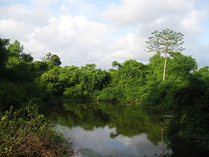
Kodungallur is a historically significant town situated on the banks of river Periyar on the Malabar Coast in Thrissur district of Kerala, India. It is 29 kilometres (18 mi) north of Kochi (Cochin) by National Highway 66 and 38 km (24 mi) from Thrissur. Kodungallur, being a port city at the northern end of the Kerala lagoons, was a strategic entry point for the naval fleets to the extensive Kerala backwaters.

Colonial India was the part of the Indian subcontinent that was occupied by European colonial powers during the Age of Discovery. European power was exerted both by conquest and trade, especially in spices. The search for the wealth and prosperity of India led to the colonisation of the Americas after Christopher Columbus went to the Americas in 1492. Only a few years later, near the end of the 15th century, Portuguese sailor Vasco da Gama became the first European to re-establish direct trade links with India by being the first to arrive by circumnavigating Africa. Having arrived in Calicut, which by then was one of the major trading ports of the eastern world, he obtained permission to trade in the city from the Saamoothiri Rajah. The next to arrive were the Dutch, with their main base in Ceylon. Their expansion into India was halted after their defeat in the Battle of Colachel to the Kingdom of Travancore, during the Travancore–Dutch War.

Valluvanad was an independent chiefdom in present-day central Kerala that held power from the early 12th century to the end of the 18th century. Prior to that, and since the late 10th century, Valluvanad existed as an autonomous chiefdom within the kingdom of the Chera Perumals. The disintegration of the Chera Perumal kingdom in early 12th century led to the independence of the various autonomous chiefdoms of the kingdom, Valluvanad being one of them.

The Kingdom of Cochin, also known as the Kingdom of Kochi or later as Cochin State, named after its capital in the city of Kochi (Cochin), was an Indian Hindu kingdom in the central part of present-day Kerala state. It commenced at the early part of the 12th century and continued to rule until its accession to the Dominion of India in 1949.
Fort Kochi, also known by its former name Fort Cochin or British Cochin is a neighbourhood of Cochin (Kochi) city in Kerala, India. Fort Kochi takes its name from the Fort Manuel of Cochin, the first European fort on Indian soil, controlled by the Portuguese East Indies. This is part of a handful of water-bound islands and islets toward the south-west of the mainland Kochi, and collectively known as Old Cochin or West Cochin. Adjacent to this is the locality of Mattancherry. In 1967, these three municipalities along with a few adjoining areas, were amalgamated to form the Kochi Municipal Corporation.

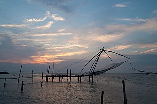
Ponnani is a municipality in Ponnani Taluk, Malappuram District, in the state of Kerala, India. It serves as the administrative center of the Taluk and Block Panchayat of the same name. It is situated at the estuary of Bharatappuzha, on its southern bank, and is bounded by the Arabian Sea on the west and a series of brackish lagoons in the south.

Malabar District, also known as Malayalam District, was an administrative district on the southwestern Malabar Coast of Bombay Presidency (1792–1800), Madras Presidency (1800–1937), Madras Province (1937–1950) and finally, Madras State (1950–1956) in India. It was the most populous and the third-largest district in the erstwhile Madras State. The historic town of Calicut was the admisnitrative headquarters of this district.

Palakkad Fort is an old fort situated in the heart of Palakkad city of Kerala state, southern India. It was recaptured and rebuilt grandly by Sultan Hyder Ali in 1766 A.D and remains one of the best-preserved forts in Kerala.

Tanur is a coastal town, a municipality, and a block located in Tirur Taluk, Malappuram district, Kerala, India. It is located on the Malabar Coast, 9 kilometres (5.6 mi) north of Tirur and 9 kilometres south of Parappanangadi. It is the 17th-most populated municipality in the state, the fourth-most populated municipality in the district, and the second-most densely populated municipality in Malappuram district, having about 3,568 residents per square kilometre as of the year 2011.
Kochi is an ancient city located in the Ernakulam District in the Indian state of Kerala about 200 km from Trivandrum, the capital of Kerala.

Rama Varma I often referred to as Dharma Raja, was the Maharajah of Travancore from 1758 until his death in 1798. He succeeded his uncle Marthanda Varma, who is credited with the title of "maker of modern Travancore". During his reign Dharma Raja not only retained all the territories his predecessor had gained but administered the kingdom with success. He was addressed as Dharma Raja on account of his strict adherence to Dharma Sastra, the Hindu principles of justice by providing asylum to thousands of Hindus and Christians fleeing Malabar during the Mysorean conquest of Malabar.
Nedumkotta or Travancore lines was a wall built as a protection against consistent invasions from Mysore during the rule of Tipu Sultan. It was built by the Dharma Raja Karthika Thirunal, King of Travancore, with the request, support and permission of the Kingdom of Kochi. It was constructed by Rama Varma under the supervision of his commander Eustachius De Lannoy. The work was started in 1762 it was completed only by 1775. The lines consist of a ditch about sixteen feet broad and twenty feet deep with a thick bamboo hedge in it, a slight parapet and good rampart and bastions on rising grounds almost flanking each other from one extreme of the lines to the other. The construction of Nedumkotta or the Travancore Lines is considered to be a unique and unparallel episode in Indian History by historians.
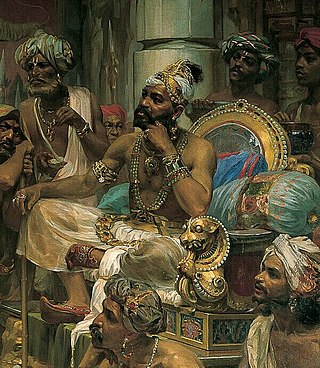
The Samoothiri was the title of the erstwhile ruler and monarch of the Kingdom of Kozhikode (Calicut) in the South Malabar region of India. Originating from the former feudal kingdom of Nediyiruppu Swaroopam, the Samoothiris and their vassal kings from Nilambur Kovilakam established Calicut as one of the most important trading ports on the southwest coast of India. At the peak of their reign, they ruled over a region extending from Kozhikode Kollam to the forested borders of Panthalayini Kollam (Koyilandy). The Samoothiris belonged to the Eradi subcaste of the Samantan community of colonial Kerala, and were originally the ruling chiefs of Eranad. The final Zamorin of Calicut committed suicide by setting fire to his palace and burning himself alive inside it, upon learning that Hyder Ali had captured the neighboring country of Chirackal in Kannur.
The Kingdom of Tanur was one of the numerous feudal principalities on the Malabar Coast of the Indian subcontinent during the Middle Ages. It was ruled by a Hindu dynasty, claiming kshatriya status, known as the Tanur dynasty. The kingdom comprised parts of the coastal Taluks of Tirurangadi, Tirur, and Ponnani taluks in present-day Malappuram district and included places such as Tanur, Tirur (Trikkandiyur) and Chaliyam. The coastal villages of Kadalundi and Chaliyam in the southernmost area of Kozhikode district was also under Tanur Swaroopam.

The Mysorean invasion of Malabar (1766–1792) was the military invasion of the Malabar region of Kerala, including the territories of the Zamorin of Calicut, by the then-de facto ruler of the Kingdom of Mysore, Hyder Ali. After the invasion, the Kingdom of Cochin to the south of Malabar became a tributary state of Mysore.
The Mysore's campaigns against the states of Malabar was the result of the Calicut's attack on Palghat in 1756–1757. This comprised the attacks of the Zamorin of Calicut on the Kingdom of Palakkad, situated east to Calicut. It was a continuation of the attacks on the Kingdom of Valluvanad, the traditional rival of Calicut. In the one sided Valluvanad attacks the Zamorin had captured much of the land from Eranad to Nedunganad. So, this time Zamorin marched against Palakkad and easily occupied Nadvattom which tore the Kingdom of Palakkad right through the middle.
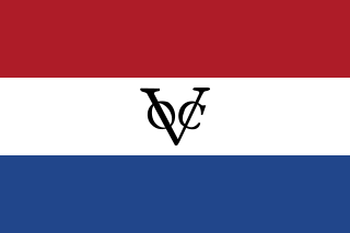
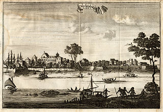
Dutch Malabar also known by the name of its main settlement Cochin, were a collection of settlements and trading factories of the Dutch East India Company on the Malabar Coast between 1661 and 1795, and was a subdivision of what was collectively referred to as Dutch India. Dutch presence in the Malabar region started with the capture of Portuguese Quilon, expanded with the Conquest of Malabar (1658-1663), and ended with the conquest of Malabar by the British in 1795. They possessed military outposts in 11 locations: Alleppey, Ayacotta, Chendamangalam, Pappinivattom, Ponnani, Pallipuram, Cranganore, Chetwai, Cannanore, Cochin, and Quilon.
Ravi Varma Raja (1745–1793) was a Samantan Nair warrior prince of the Royal House of Zamorins from Calicut who fought a two-decade long revolt against the Mysore Sultanate under Hyder Ali and Tipu Sultan between 1766–1768 and 1774–1791, and later the British East India Company in 1793.

The Kingdom of Kozhikode, also known as Calicut, was the kingdom of the Zamorin of Calicut, in the present-day Indian state of Kerala. Present-day Kozhikode is the second largest city in Kerala, as well as the headquarters of Kozhikode district.
Malappuram is one of the 14 districts in the South Indian state of Kerala. The district has a unique and eventful history starting from pre-historic times. During the early medieval period, the district was the home to two of the four major kingdoms that ruled Kerala. Perumpadappu was the original hometown of the Kingdom of Cochin, which is also known as Perumbadappu Swaroopam, and Nediyiruppu was the original hometown of the Zamorin of Calicut, which is also known as Nediyiruppu Swaroopam. Besides, the original headquarters of the Palakkad Rajas were also at Athavanad in the district.