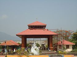
Malampuzha Dam

Last updated

Malampuzha Dam
Malampuzha Dam Navas 10.jpg
India relief location map.jpg
Red pog.svg
Location of Malampuzha Dam in India
India Kerala relief map.svg
Red pog.svg
Malampuzha Dam (Kerala)
Official name
Malampuzha Dam panoramic shot Malampuzha-dam-2019.jpg
Malampuzha Dam panoramic shot
Location Palakkad District, Kerala
Coordinates 10°49′49.8″N76°41′1.5″E / 10.830500°N 76.683750°E / 10.830500; 76.683750
Construction beganMarch 1949
Opening date9 October 1955
Dam and spillways
Impounds Malampuzha river
Height115.06 m
Length2,069 m
Reservoir
CreatesMalampuzha Reservoir
Total capacity226 million cubic metres [1] (8 tmc ft)
Catchment area 147.63 sq. km.

Malampuzha Dam is the second largest dam and reservoirs in Kerala, [2] located near Palakkad, in the state of Kerala in South India, built post independence by the then Madras state. Situated in the scenic hills of the Western Ghats in the background it is a combination of a masonry dam with a length of 1,849 metres and an earthen dam with a length of 220 metres making it the longest dam in the state. [3] The dam is 355 feet high and impounds the Malampuzha River, a tributary of Bharathappuzha, Kerala's second longest river. There is a network of two canal systems that serve the dam's reservoir of 42,090 hectares. [4]

Contents

Construction

The dam project was begun in 1949 and completed in 1955. foundation stone for the project was laid on 27 March 1949, by the then Public Works Minister of Madras State, Sri M. Bhaktavatsalam as Palakkad was a part of the Madras Presidency during those times. The dam was constructed in record time, and on 9 October 1955, the then Chief Minister of Madras State, Thiru. K Kamaraj, inaugurated the dam. The total catchment area is 147.63 square kilometres, [5] and the reservoir has a capacity of 226 million cubic meters [5] of water. The canal systems serve to irrigate farmland while the reservoir provides drinking water to Paladin and surrounding villages. [4] The dam was constructed by the Madras government but upon the Creation of linguistically reorganized states, The Malabar District encompassing the Dam became a part of the Kerala State.

Location

15 km from Palakkad city, North Kerala. Attractions: Dam, amusement park, boating facilities, rock garden and ropeway.

Around the reservoir of the dam are gardens and amusement parks. Boating facilities are available on the lake.

Getting there

Nearest railway station: Palakkad Junction - 14 km [6]

Nearest airport: Coimbatore, 55 km from Malampuzha Dam [7]

MALAMPUZHA DAM OUTLET WATER CANAL MALAMPUZHA DAM OUTLET WATER CANAL.jpg
MALAMPUZHA DAM OUTLET WATER CANAL

Main Attractions

The fish shaped aquarium Malampuzha Garden 10.jpg
The fish shaped aquarium

See also

Related Research Articles

<span class="mw-page-title-main">Palakkad district</span> District in Kerala, India

Palakkad is one of the 14 districts in the Indian state of Kerala. It was carved out of the southeastern region of the former Malabar District on 1 January 1957. It is located at the central region of Kerala and is the second largest district in the state after Idukki. The city of Palakkad is the district headquarters. Palakkad is bordered on the northwest by the Malappuram district, on the southwest by the Thrissur district, on the northeast by Nilgiris district, and on the east by Coimbatore district of Tamil Nadu. The district is nicknamed "The granary of Kerala". Palakkad is the gateway to Kerala due to the presence of the Palakkad Gap, in the Western Ghats. The 2,383 m high Anginda peak, which is situated in the border of Palakkad district, Nilgiris district, and Malappuram district, in Silent Valley National Park, is the highest point of elevation in Palakkad district. Palakkad city is about 347 kilometres (216 mi) northeast of the state capital, Thiruvananthapuram.

<span class="mw-page-title-main">Kerala backwaters</span> Lagoon network in India

The Kerala backwaters are a network of brackish lagoons and canals lying parallel to the Arabian Sea of the Malabar coast of Kerala state in south-western India. It also includes interconnected lakes, rivers, and inlets, a labyrinthine system formed by more than 900 km (560 mi) of waterways, and sometimes compared to bayous. The network includes five large lakes linked by canals, both man made and natural, fed by 38 rivers, and extending virtually half the length of Kerala state. The backwaters were formed by the action of waves and shore currents creating low barrier islands across the mouths of the many rivers flowing down from the Western Ghats range. In the midst of this landscape there are a number of towns and cities, which serve as the starting and end points of backwater cruises. There are 34 backwaters in Kerala. Out of it, 27 are located either closer to Arabian Sea or parallel to the sea. The remaining 7 are inland navigation routes.

<span class="mw-page-title-main">Pothundi Dam</span> Dam in Palakkad District, Kerala

Pothundi Dam is an irrigation dam near Pothundi village in the Palakkad district of Kerala state, India. Constructed in the 19th century, it is considered one of the oldest dams in India. It provides irrigation to an area of 5,470 hectares in the Palakkad district and drinking water supply to the Nemmara, Ayalur, Melarcode Panchayat. An unusual feature of the earth dam is the core wall, which is built with a mixture of jaggery and quick lime.

<span class="mw-page-title-main">Malampuzha</span> Town in Kerala, India

Malampuzha is a town in Palakkad district of Kerala, India. It is located about 3.5 km (2.2 mi) from Malampuzha Dam and 14 km (8.7 mi) from Palakkad city.

<span class="mw-page-title-main">Neyyar Dam</span> Dam in Kerala, India

Neyyar dam is a gravity dam on the Neyyar River in Thiruvananthapuram district of Kerala, South India, located on the foot of the Western Ghats about 30 km from Thiruvananthapuram. It was established in 1958 and is a popular picnic spot.

Malampuzha River is one of the tributaries of the river Kalpathipuzha. Malampuzha Dam is built across the river at Malampuzha about 8 km from the Palakkad city in the Indian state of Kerala. The reservoir formed by the Malampuzha Dam is 23.13 square kilometres in area and is the second largest reservoir in Kerala after the Idukki reservoir. The construction of Malampuzha dam started in the year 1949 and was completed in the year 1955. The project is estimated to have cost around Rs. 53 million. Malampuzha river joins the Kalpathipuzha, a tributary of the Bharathapuzha at Palakkad. Kalpathipuzha then flows westward to join Kannadipuzha at Parali to form Bharathapuzha, which ultimately flows until Ponnani, passing through towns and villages Mankara, Pathirippala, Lakkidi, Thiruvilwamala, Ottapalam, Mayannur, Shoranur, Cheruthuruthy, Thirumittakode, Pattambi, Thrithala, Kudallur, Kuttippuram, Thirunavaya and Chamravattom.

<span class="mw-page-title-main">Palakkad</span> City in Kerala, India

Palakkad, also known as Palghat, historically known as Palakkattussery, is a city and municipality in the Indian state of Kerala. It is the administrative headquarters of Palakkad District. Palakkad is the most densely populated municipality and the fourth-most densely populated city in the state. It was established before Indian independence under British rule and known by the name Palghat. Palakkad is famous for the ancient Palakkad Fort, which is in the heart of the city and was captured and rebuilt by Hyder Ali in 1766 which later fell into the hands of Zamorin in 1784. The city is about 347 kilometres (216 mi) northeast of the state capital, Thiruvananthapuram.

<span class="mw-page-title-main">Thenmala</span> Village in Kerala, India

Thenmala is a tourist destination in the eastern side of Kollam district in Kerala, India that is home to the first eco-tourism centre in India. The word 'Thenmala' means "Honey hill" in Malayalam language. It is known for its high quality honey export. The town is 66 km away from Kollam city, 69 km from the state capital Trivandrum and is just 14 km away from Tamil Nadu state border. The interstate National Highway-744, connecting Kollam with Madurai in Tamil Nadu, and State Highway-2 of Kerala are passing through Thenmala.

<span class="mw-page-title-main">Banasura Sagar Dam</span> Dam in Padinjarathara, Wayanad, Kerala

Banasura Sagar Dam, Situated in Padinjarathara in Kerala and it is the Largest Earth Dam in India and Second Largest Dam in Asia Banasura Dam is under the control of Padinjarathara KSEB Station. India's First Operating Floating Solar Power Plant was established in Banasura Dam. The Dam is surrounded by Banasura Hills. Dam impounds the Karamanathodu tributary of the Kabini River, is part of the Indian Banasurasagar Project consisting of a dam and a canal project started in 1979. The goal of the project is to support the Kakkayam Hydro electric power project and satisfy the demand for irrigation and drinking water in a region known to have water shortages in seasonal dry periods. The dam is also known as Kuttiyadi Augmentation Main Earthen Dam. The dam has a height of 38.5 metres (126 ft) and length of 776 metres (2,546 ft).

<span class="mw-page-title-main">Perunchani Dam</span> Dam in Tamil Nadu, India

Perunchani Dam is an irrigation dam at Perunchani, Kanyakumari District, in the state of Tamil Nadu, India. It is one of the dams of the Kodayar Irrigation System. As there was water deficiency in the Kodayar Irrigation System, Perunchani Dam was constructed in December 1952 to store flood water of the Paralayar River as an extension. It was built about 1 km (0.62 mi) upstream of the Puthen dam on the Paralayar River. The irrigation system became operational on 2 September 1953. It feeds the left bank irrigation canal system of the Puthen dam, which is the terminal structure of the system.

<span class="mw-page-title-main">Aliyar Reservoir</span> Reservoir in Tamil Nadu, India

Aliyar Reservoir is a 6.48 km2 (2.5 sq mi) reservoir located in Aliyar village near Pollachi town in Coimbatore District, Tamil Nadu, South India. The dam is located in the foothills of Valparai, in the Anaimalai Hills of the Western Ghats. It is about 65 kilometres (40 mi) from Coimbatore. The dam offers some ideal getaways including a park, garden, aquarium, play area and a mini Theme-Park maintained by Tamil Nadu Fisheries Corporation for visitors enjoyment. The scenery is beautiful, with mountains surrounding three quarters of the reservoir. Boating is also available.

<span class="mw-page-title-main">Bharathappuzha</span> River in India

The Bharathappuzha, also known as the Nila or Ponnani River, is a river in the Indian states of Tamil Nadu and Kerala. With a length of 209 km, it is the second longest river that flows through Kerala after the Periyar. It flows through Palakkad Gap, which is also the largest opening in the Kerala portion of Western Ghats. The Nila has groomed the culture and life of South Malabar part of Kerala. It is also referred to as the "Peraar" in ancient scripts and documents. River Bharathapuzha is an interstate river and lifeline water source for a population residing in four administrative districts, namely Malappuram and Palakkad districts, and parts of Palakkad-Thrissur district border of Kerala and Coimbatore, and Tiruppur of Tamil Nadu. The fertile Thrissur-Ponnani Kole Wetlands lie on its bank.

<span class="mw-page-title-main">Tungabhadra Dam</span> Dam in Karnataka, India

The Tungabhadra Dam, also known as Pampa Sagar, is a water reservoir constructed across the Tungabhadra River in the Hosapete-Koppal confluence in Karnataka, India. It is a multipurpose dam serving irrigation, electricity generation, flood control, etc. for the state. It is India's largest stone masonry dam and one of the only two non-cement dams in the country, the other being the Mullaperiyar Dam in Kerala. The dam is built of surki mortar, a combination of mud and limestone, commonly used at the time of its construction.

<span class="mw-page-title-main">Siruvani Dam</span> Dam in Palakkad, Kerala

Siruvani dam is a dam in Palakkad District, Kerala located 46 km away from Palakkad town. This dam constructed across the Siruvani River, is for supplying drinking water to the city of Coimbatore in Tamil Nadu. The dam is surrounded by reserve forests. Muthikulam hill is situated on the eastern side of the dam. There is a natural waterfall in the hill. The waterfalls and the Dam are big tourist attractions. The famous 150-year-old Pattiyar Bungalow is on the banks of the Siruvani Reservoir. An agreement was executed in August 1973 between the state Governments for drinking water supply to Coimbatore town and neighbouring areas from the Siruvani Dam. The location being in the state of Kerala, the project was executed by the Kerala Public Works Department using the funds made available by the Tamil Nadu Government. The gross storage capacity of the dam is 9 tmc ft

<span class="mw-page-title-main">Thunakkadavu Dam</span> Dam in Palakkad district, Kerala

Thunakkadavu Dam is situated in Parambikulam Wildlife Sanctuary, Kerala across Thoonakkadavu River, which is a tributary of Parambikulam River, in Palakkad district of Kerala, India. It is part of the Parambikulam-Aliyar Irrigation Project. It is in the Parambikulam Wildlife Sanctuary in the Muthalamada panchayath.

<span class="mw-page-title-main">Kanjirapuzha Dam</span> Dam in Kerala, India

The Kanjirapuzha Dam, a masonry earth dam built for providing irrigation to a Cultural Command Area (CCA) of 9,713 hectares, is located in the Palakkad district in the Indian state of Kerala. The reservoir, which has three islands within it, also has an established commercial fisheries development programme operated by the Fisheries Department.

Palakkad district has a large number of temples, churches, mosques and other tourist attractions. Palakkad district is situated in the middle of Kerala state in South India. The nearest airports are at Coimbatore in Tamil Nadu and Cochin in Kerala.

Waterways have always been an important mode of transport in Kerala. The total length of navigable route in Kerala was 1,900 kilometres and the navigable rivers constitute about 54 per cent of the waterways. The 41 West-flowing rivers together with the backwaters are an integrated part of the inland navigation system in Kerala. In Kerala water transportation through these channels are mainly small distant passenger services, informal country boats, freight transportation to PSU's such as Fertilisers and Chemicals Travancore, Kochi etc.

Meenkara Dam is an embankment or earthen dam built on the banks of the river Gayatripuzha, a tributary of the river Bharathapuzha, at Muthalamada in the Muthalamada Grama Panchayat near Kollengode in the Palakkad district of Kerala with masonry spillway sections. It is part of the Gayatri Irrigation Project. The project was started in 1956 and partially commissioned in 1960. The project was fully completed in 1964. The irrigation scheme has been prepared for agriculture and drinking water in Palakkad district. Farms in Chittoor, Nemmara, Alathur in Palakkad district and Vadakkancherry in Thrissur district will benefit from this irrigation scheme.

<i>Yakshi</i> (sculpture) Sculpture in Kerala, India

Yakshi is a sculpture in Malampuzha park, Palakkad adjacent to the Malampuzha Dam in the Indian state of Kerala. Sculptored by Kanayi Kunhiraman, its construction was completed in 1969. It is a 30 ft (9.1 m) tall sculpture inspired by a nude female yakshi, with her legs spread out, breasts lifted, eyes raised to the sky in a semi-drowsy state and fingers running through her hair. The sculpture is constructed in a single piece. Kunhiraman was honoured by Kerala Government in 2019 during the 50th anniversary of the sculpture.

References

  1. "Malampuzha Dam, Brief about project". India-WRIS, National Remote Sensing Centre.
  2. "National Register of Large Dams | Central Water Commission, Ministry of jal shakti, Department of Water Resources, River Development and Ganga Rejuvenation, GoI". cwc.gov.in. Retrieved 28 May 2020.
  3. "Malampuzha dam to celebrate Golden Jubilee". The Hindu . Chennai, India. 19 August 2005. Archived from the original on 7 November 2009. Retrieved 5 February 2008.
  4. 1 2 "About Malampuzha Dam".
  5. 1 2 "Malampuzha Project | Irrigation-kerala". irrigation-kerala.org. Retrieved 17 September 2023.[ dead link ]
  6. "How to Reach Malampuzha Dam".
  7. "Malampuzha Dam - Distance from Towns".