Bekal

Last updated

Bekal
Town
Bekal.jpg
India Kerala location map.svg
Red pog.svg
Bekal
Location in Kerala, India
India location map.svg
Red pog.svg
Bekal
Bekal (India)
Coordinates: 12°25′13″N75°01′23″E / 12.4204°N 75.0231°E / 12.4204; 75.0231
CountryFlag of India.svg  India
State Kerala
District Kasaragod
Taluk Hosdurg
Government
  Type Panchayati raj (India)
  BodyPallikara Panchayat, Udma Panchayat
   Deputy Superintendent of Police C.K. Sunil Kumar [1]
Languages
  Official Malayalam, English
Time zone UTC+5:30 (IST)
PIN
671318, 671319
Telephone code04672
ISO 3166 code IN-KL
Vehicle registration KL-60
Nearest cityKanhangad
Assembly constituency Udma
Lok Sabha constituency Kasaragod

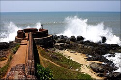
Bekal is a small town in the Kasaragod district on the West coast of the state of Kerala, India. [2]

Contents

Location

Bekal is a town located 12 km (7.5 mi) south of Kasaragod town and 14 km (8.7 mi) north of Kanhangad on the State Highway 57. Bekal Fort is the largest fort in Kerala state situated adjacent to the beach. Shaped like a giant keyhole, the historic Bekal Fort offers a view of the Arabian Sea from its tall observation towers, which had huge cannons a couple centuries ago.

The state of Kerala is reviewing a plan to start seaplane services connecting Bekal with Kollam Ashtamudi, Kumarakom, Punnamada and famous Paravur backwaters. Bekal in Northern Kerala was one of the top ten travel destinations selected by Lonely Planet. [3]

Local roads have access to NH 66 which connects to Mangalore in the north and Calicut in the south. The nearest railway station is Kanhangad on Mangalore-Palakkad line. There are airports at Mangalore, Calicut and Kannur.

Transportation

Kerala State Highway connects to Kasaragod in the north and Kanhangad in the south. The nearest railway station is Bekal Fort Railway Station, Kotikulam Railway Station and Kanhangad Railway Station on Mangalore-Palakkad line. There are airports at Mangalore, Kannur and Calicut.

Related Research Articles

<span class="mw-page-title-main">Kasaragod</span> Municipal city in Kerala, India

Kasaragod is a municipal town and administrative headquarters of Kasaragod district in the state of Kerala, India. Established in 1966, Kasaragod was the first municipal town in the district. It is the northernmost district of Kerala and is also known as Saptha Bhasha Sangama Bhoomi.

<span class="mw-page-title-main">Bekal Fort</span> Place in Kerala, India

Bekal Fort is a medieval fort built by Shivappa Nayaka of Keladi in 1650 AD, at Bekal. It is the largest fort in Kerala, spreading over 40 acres (160,000 m2).

<span class="mw-page-title-main">Kanhangad</span> Municipality in Kerala, India

Kanhangad is a town, located in the Kasaragod District, state of Kerala, India.

<span class="mw-page-title-main">Udma</span> Census Town in Kerala, India

Udma is a census town in Kasaragod district in the Indian state of Kerala.

<span class="mw-page-title-main">Kasaragod district</span> District in Kerala, India

Kasaragod is one of the 14 districts in the southern Indian state of Kerala. Its northern border Thalappady is located just 10 km south to Ullal, which is the southernmost portion of the major port city Mangalore, on the southwestern Malabar coast of India.

Ambalathara is a village in Kasaragod district in the state of Kerala, India.

<span class="mw-page-title-main">Bandadka</span> Small Town in Kerala, India

Bandadka is a small town in Kasaragod district in the state of Kerala, India. It is also called as Kottakal because of Bandadka Fort. It comes under Kuttikole Grama Panchayat. It is located 38 km (24 mi) towards east from District headquarters Kasaragod, 568 km (353 mi) away from State capital Thiruvananthapuram, 5 km (3.1 mi) west of Karnataka border and 20 km (12 mi) away from Sullia. Bandadka Pin code is 671541 and postal head office is Chengala.

Karindalam is a village in Kasaragod district in the state of Kerala, India.

Panayal is a village in Kasaragod district in the state of Kerala, India. It is situated approximately 6 km inland from the coastal town of Bekal. Panayal is 18.3 km by road from Kasaragod and around 14.9 km from Kanhangad. Sri Mahalingeshwara Aided Upper Primary School and the Sri Mahalingeshwara Shiva temple are located here. Panayal is known for the Theyyam art form performed in the many family shrines in the area.

<span class="mw-page-title-main">Periya, Kasaragod</span> Village in Wayanad District, Kerala, India

Periya is a small township in Kasaragod District, Kerala State, India.

<span class="mw-page-title-main">Pilicode</span> Village in Kerala, India

Pilicode is a village in Kasaragod district in the state of Kerala, India. On 2018-04-12 chief minister Pinarayi Vijayan declared Pilicode as first filament bulb free Panchayat in India as part of Oorjayaanam (ഊര്‍ജയാനം) project.

<span class="mw-page-title-main">Poinachi Junction</span> Town in Kerala, India

Poinachi is a small town on National Highway 66, about 16 km south of the town of Kasaragod, Kerala, India. It also serves as an origination point for a road running east to Bandadka.

Konnakkad is a hilly region in Maloth village of Kasaragod District in the state of Kerala. Konnakkad is Located in Kerala-Karnataka Border.

<span class="mw-page-title-main">Pallikkara, Bekal</span> Village in Kerala, India

Pallikkara is a census town and a grama panchayat in Hosdurg Taluk of Kasargod district in the state of Kerala, India. This place was once famous for its Tobacco plants until the late 1980s and the Historical landmark Bekal Fort lies in this Village. A beach park near to the fort also attracts tourists to this place.

Kolavayal is a place in Ajanur village in Kanhangad town, Kasaragod district, Kerala, India. It is a coastal place.

<span class="mw-page-title-main">Vellarikundu</span> Town in Kerala, India

Vellarikundu is a town and taluk headquarters in the Hill range of Kasaragod District in the state of Kerala. Vellarikundu is located between Odayanchal and Chittarikkal on Odayanchal-Cherupuzha Road.

<span class="mw-page-title-main">Panathur</span> Town in Kerala, India

Panathur is a major town in Vellarikundu Taluk of Kasaragod district in Kerala State, India. It belongs to Kanhangad legislative constituency. Its population is about 12,000. It lies 1 km away from Kerala - Karnataka border, 42 km away from the nearest municipality, Kanhangad and 53 km away from the district headquarters, Kasaragod. It is surrounded from three sides by forest reserves and cashew plantations. Kudumbur River flows adjacent to the town.

<span class="mw-page-title-main">Podippalam</span>

Podippalam is a village in Kasaragod district in the state of Kerala, India.

Kozhikode district has an extensive network of road, rail and air travel services. Kozhikode city is the epicenter of the district. Vatakara and Thamarassery are other transport hubs.

<span class="mw-page-title-main">Mulleria, Kasaragod</span> Town in Kerala, India

Mulleria is a small town located in Karadka Panchayath, Kasaragod district in Kerala, India.

References

  1. "Kerala Police - List of Police officers to the cadres of DySP/ACP" (PDF).
  2. "Bekal". keralatourism.org. Archived from the original on 22 September 2012. Retrieved 20 June 2012.
  3. Lonely Planet Top Ten Destinations Asia