| Idukki Dam | |
|---|---|
 | |
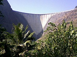
 Idukki Dam Location of Idukki Dam in Kerala | |
| Country | India |
| Location | Idukki, Kerala |
| Coordinates | 9°50′34″N76°58′34″E / 9.84278°N 76.97611°E |
| Purpose | Power generation |
| Status | Operational |
| Construction began | 1963 |
| Opening date | 1976 |
| Owner | Kerala State Electricity Board |
| Dam and spillways | |
| Type of dam | Concrete, double curvature parabolic, thin arch. |
| Impounds | Periyar River |
| Height | 168.91 m (554 ft) |
| Height (foundation) | 169.16 meters |
| Length | 365.85 m (1,200 ft) |
| Dam volume | 450,000 m3 (16,000,000 cu ft) |
| Spillways | Nil |
| Reservoir | |
| Total capacity | 1.996 km3 (70.5 tmc ft) |
| Active capacity | 1,460×106 m3 (1,183,641 acre⋅ft) (51.57 tmc ft) |
| Inactive capacity | 536×106 m3 (434,542 acre⋅ft) (18.93 tmc ft) |
| Catchment area | 649.3 km2 (251 sq mi) |
| Surface area | 60 km2 (23 sq mi) |
| Normal elevation | 732.62 m (2,404 ft) |
| Power Station | |
| Commission date | 1975 |
| Turbines | 6 x 130 MW Pelton-type |
| Installed capacity | 780 MW |

The Idukki Dam is a double-curvature thin arch dam constructed across the Periyar River in a narrow gorge between two granite hills locally known as Kuravan and Kurathi in Idukki district in the state of Kerala, India. It is constructed and owned by the Kerala State Electricity Board. It supports a 780 MW hydroelectric power station in Moolamattom, which started generating power on 4 October 1975. [1] At 168.91 metres (554.2 ft), it is one of the highest arch dams in Asia. The Indo-Canadian project was inaugurated by Prime Minister Indira Gandhi on February 17, 1976. [2]
Contents
- History
- Early surveys
- Construction
- Features
- Usage
- Power generation
- Irrigation
- Tourism
- See also
- References
- External links
This dam was constructed along with two other dams at Cheruthoni and Kulamavu. Together, the three dams and Two saddle dams, Kulamavu Saddle Dam (Near Junction) and Kulamavu Saddle Dam (Right Bank) have created an artificial lake that is 60 km2 (23 sq mi) in area. The stored water is used to produce electricity at the Moolamattom Power house, which is located inside nearby rocky caves. [1]
Narakakkanam, Azhutha, Vazhikkadavu, Vadakkepuzha and Kuttiar diversion schemes were later added to augment the Idukki reservoir .