Kollam, also known by its former name Quilon, is an ancient seaport and city on the Malabar Coast of India bordering the Laccadive Sea, which is a part of the Arabian Sea. It is 71 km (44 mi) north of the state capital Thiruvananthapuram. The city is on the banks of Ashtamudi Lake and the Kallada river. Kollam is the fourth largest city in Kerala and is known for cashew processing and coir manufacturing. It is the southern gateway to the Backwaters of Kerala and is a prominent tourist destination. Kollam is one of the most historic cities with continuous settlements in India. Geographically, Quilon formation seen around coastal cliffs of Ashtamudi Lake, represent sediments laid down in the Kerala basin that existed during Mio-Pliocene times.

The Kerala backwaters are a network of brackish lagoons and canals lying parallel to the Arabian Sea of the Malabar coast of Kerala state in south-western India. It also includes interconnected lakes, rivers, and inlets, a labyrinthine system formed by more than 900 km (560 mi) of waterways, and sometimes compared to bayous. The network includes five large lakes linked by canals, both man made and natural, fed by 38 rivers, and extending virtually half the length of Kerala state. The backwaters were formed by the action of waves and shore currents creating low barrier islands across the mouths of the many rivers flowing down from the Western Ghats range. In the midst of this landscape there are a number of towns and cities, which serve as the starting and end points of backwater cruises. There are 34 backwaters in Kerala. Out of it, 27 are located either closer to Arabian Sea or parallel to the sea. The remaining 7 are inland navigation routes.

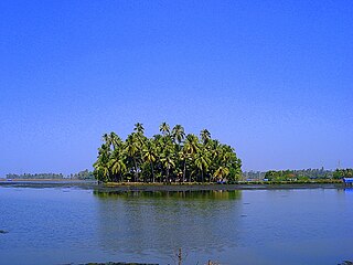
Ashtamudi Lake, in the Kollam District of the Indian state of Kerala. It possesses a unique wetland ecosystem and a large palm-shaped water body, second only in size to the Vembanad estuary ecosystem of the state. Ashtamudi means 'eight braids' in the local Malayalam language. The name is indicative of the lake's topography with its multiple branches. The lake is also called the gateway to the backwaters of Kerala and is well known for its houseboat and backwater resorts. Ashtamudi Wetland was included in the list of wetlands of international importance, as defined by the Ramsar Convention for the conservation and sustainable utilization of wetlands.
Kollam district, is one of 14 districts of the state of Kerala, India. The district has a cross-section of Kerala's natural attributes; it is endowed with a long coastline, a major Laccadive Sea seaport and an inland lake. The district has many water bodies. Kallada River is one among them, and land on the east bank of the river is East Kallada and that on the west bank is West Kallada.
Fort Kochi, Fort Cochin in English, Cochim de Baixo in Cochin Portuguese creole, is a neighbourhood of Cochin (Kochi) city in Kerala, India. Fort Kochi takes its name from the Fort Manuel of Cochin, the first European fort on Indian soil, controlled by the Portuguese East Indies. This is part of a handful of water-bound islands and islets toward the south-west of the mainland Kochi, and collectively known as Old Cochin or West Cochin. Adjacent to this is the locality of Mattancherry. In 1967, these three municipalities along with a few adjoining areas, were amalgamated to form the Kochi Municipal Corporation.

Marine Drive, also known as APJ Abdul Kalam Marg, is a famous promenade in Kochi, India. It is built facing the backwaters, and is a popular hangout for the local populace. Despite its name, no vehicles are allowed on the walkway. Marine Drive is also an economically thriving part of the city of Kochi. With several shopping malls it is as an important centre of shopping activity in Kochi. Major fast food joints, including Marrybrown, DiMark, Coffee Bar are present along the walkway.

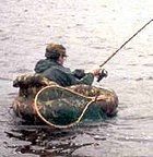
Artisanal fishing consists of various small-scale, low-technology, low-capital, fishing practices undertaken by individual fishing households. Many of these households are of coastal or island ethnic groups. These households make short fishing trips close to the shore. Their produce is usually not processed and is mainly for local consumption. Artisan fishing uses traditional fishing techniques such as rod and tackle, fishing arrows and harpoons, cast nets, and small traditional fishing boats. For that reason, socio-economic status of artisanal fishing community has become an interest of the authorities in recent years.
Aroor is a census town at the southern entry of Kochi city and the southern part of Kochi in the state of Kerala, India. It is a seafood related industrial area of Kochi. Aroor–Thuravoor Elevated Highway will be India's longest elevated highway upon completion.

Basnig or balasnig are lift nets (salambaw) operated by a large outrigger boat called Basnigan. They use a large bag net suspended directly below or beside the ship. This net is attached to multiple temporary booms projecting from the ship's outriggers and detachable auxiliary masts. Modern basnig typically use generators and electric lights to attract fish and squid. This method is unique to the Philippines. It is common in the Visayas, particularly in the provinces of Capiz and Iloilo.
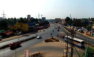
Karunagappally is a municipality in the Kollam district of Kerala, India. It is 24 km north of Kollam and 60 km (37 mi) south of Alappuzha. Karunagappally taluk consists of Alappad, Ochira, Adinad, Karunagappally, Thazhava, Pavumba, Thodiyoor, Kallalibhagom, Thevalakkara, Chavara, Neendakara, Clappana, Kulasekharapuram, Thekkumbhagam, Ayanivelikulangara, Panmana, Ponmana and Vadakumthala. The taluk is bound on the north by Kayamkulam, on the east by Kunnathur taluk, on the south by Kollam and on the west by the Arabian Sea. It is one of the fastest developing towns in Kerala and is part of Kollam metropolitan area.

Fishing techniques are methods for catching fish. The term may also be applied to methods for catching other aquatic animals such as molluscs and edible marine invertebrates.
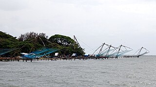
Kumbalangi is an island village in the outskirts of Kochi city in the state of Kerala, India. Situated amidst backwaters, around 12 km (7.5 mi) from the city center, Kumbalangi is a major tourist attraction and is famous for its Chinese fishing nets. It is also known among the tourists for the occurrence of the natural phenomenon known as sea sparkle or bioluminescence in the backwaters at Kumbalangi, which is locally known as Kavaru. It is the first eco-tourism village in India, according to the government agency Kerala Tourism.

The West Coast Canal or National Waterway No 3 is a 205 km (127 mi) long inland navigational route located in Kerala, India, which runs from Kollam to Kottapuram. It was declared a National Waterway in 1993. In addition to the main stretch, Champakara and Udyogmandal canals are navigable and connect the industrial centers of Kochi to Kochi port Inland Waterways Authority of India (IWAI) under the Ministry of Shipping is coordinating the task for developing, monitoring and administering national waterways. It is the first National Waterway in the country with 24-hour navigation facilities along the entire stretch. It has been extended to Kozhikode by the National Waterways Act, 2016. The National Waterway 3 mainly passes through the previous Thiruvananthapuram–Shoranur canal.
Kerala Seaplane was a commercial seaplane service promoted by Kerala Tourism Infrastructure Limited in the Indian state of Kerala. It was launched on 2 June 2013 at Kollam with the inaugural flight being operated by Kairali Aviation. However, commercial operations could not start due to opposition from the local fishing community. The Kerala Government was keen on restarting regular operations of the project in 2014. The service was to be the first such service in mainland India, and the second in India after Jal Hans, which operates seaplanes in the Andaman and Nicobar Islands. Work on the Kerala seaplane project began at the end of July, 2012 and has been praised for being one of the fastest projects to be completed in Kerala.

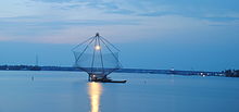
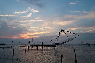
Lift nets, also called lever nets, are a method of fishing using nets that are submerged to a certain depth and then lifted out of the water vertically. The nets can be flat or shaped like a bag, a rectangle, a pyramid, or a cone. Lift nets can be hand-operated, boat-operated, or shore-operated. They typically use bait or a light-source as a fish-attractor. Lift nets are also sometimes called "dip nets", though that term applies more accurately to hand nets.

Karunagappalli railway station(Code:KPY) or Karunagappally railway station is a railway station in the Indian municipal town of Karunagappalli in Kollam district, Kerala. Karunagappalli railway station falls under the Thiruvananthapuram railway division of the Southern Railway zone of Indian Railways. Karunagappally KSRTC Bus Station is only 2 km away from the station. It is one among the railway stations in Kerala collecting crores of rupees through passenger tickets every year. Karunagappalli is the nearest railway station to Amritapuri. Free WiFi of railway is available here. Karunagappalli is connected to various cities in India like Kollam, Trivandrum, Kochi, Calicut, Palakkad, Thrissur, Punalur, Bengaluru, Udupi, Mumbai, Madurai, Kanyakumari, Vishakapatnam, Mangalore, Pune, Salem, Coimbatore, Trichy, Tirunelveli, Hyderabad etc. through Indian Railways. In 2019, the rail wi-fi broad-band connection has been introduced in Karunagappalli station.karunagappally - KMML Chavara railway line is a defunct railway line which used to carry goods to KMML in past.kothukumukku railway bridge in this old line is a tourist attraction now.
Fort Kochi beach is a beach along the Arabian Sea situated in Fort Kochi in the city of Kochi in South India, Kerala state.
Kollam or Quilon is an old seaport and a city on the Laccadive Sea coast in Kerala, India, on Ashtamudi Lake. The city remains notable as the ancient commercial capital of Kerala and the southwestern Indian coast, in addition to its fame as the "Cashew Capital of the World". The Kollam Municipal Corporation has the second largest budget in Kerala in terms of revenue and expenditure.

Salambáw, is a type of lift net used by indigenous fishermen in the Philippines. They are found throughout the Philippine islands but are most prevalent in large lakes like Laguna de Bay, and sheltered coastal areas like Manila Bay, Ragay Gulf, and Batan Bay. Variations of salambáw lift nets include the bintol, panak, tangkal, and the basnig. Salambáw rafts were also known as saraboa or salakab.

Bagan or bagang is a fishing instrument that uses nets and lights so that it can be used for light fishing, originating from Indonesia. Bagan is floated out to the sea to catch fishes, squids, and shrimps, and remain in the sea for several days or even months. The catch would be transported to land using other boats.