Fishfinder

Last updated
Fathometer sonar Fishfinder.jpg
Fathometer sonar

A fishfinder or sounder (Australia) is an instrument used to locate fish underwater by detecting reflected pulses of sound energy, as in sonar. A modern fishfinder displays measurements of reflected sound on a graphical display, allowing an operator to interpret information to locate schools of fish, underwater debris, and the bottom of a body of water. Fishfinder instruments are used both by sport and commercial fishermen. Modern electronics allow a high degree of integration between the fishfinder system, marine radar, compass and GPS navigation systems.

Contents

Fathometer

Fish finders were derived from fathometer s, active sonar instruments used for navigation and safety to determine the depth of water. [1] The fathom is a unit of water depth, from which the instrument gets its name. The fathometer is an echo sounding system for measurement of water depth. A fathometer will display water depth and can make an automatic permanent record of measurements. Since both fathometers and fishfinders work the same way, and use similar frequencies and can detect both the bottom and fish, the instruments have merged. [2]

Operating theory

In operation, an electrical impulse from a transmitter is converted into a sound wave by an underwater transducer, called a hydrophone, and sent into the water. [3] When the wave strikes something such as a fish, it is reflected back and displays size, composition, and shape of the object. The exact extent of what can be discerned depends on the frequency and power of the pulse transmitted. Knowing the speed of the wave in the water, the distance to the object that reflected the wave can be determined. The speed of sound through the water column depends on the temperature, salinity and pressure (depth). This is approximately c = 1404.85 + 4.618T - 0.0523T2 + 1.25S + 0.017D (where c = sound speed (m/s), T = temperature (degrees Celsius), S = salinity (per mille) and D = depth). [4] Typical values used by commercial fish finders are 4921 ft/s (1500 m/s) in seawater and 4800 ft/s (1463 m/s) in freshwater.

The process can be repeated up to 40 times per second and eventually results in the bottom of the ocean being displayed versus time (the fathometer function that eventually spawned the sporting use of fishfinding).

The temperature and pressure sensitivity capability of fish finder units allow one to identify the exact location of the fish in the water by the use of a temperature gauge. Functionality present in many modern fish finders also have track back capabilities in order to check the changes in movement in order to switch position and location whilst fishing.

It is easy to get more detail at screen when the frequency of fish finder is high. Deep-sea trawlers and commercial fishermen normally use low-frequency which is in between 50-200 kHz where modern fish finders have multiple frequencies to view split screen results.

General interpretation
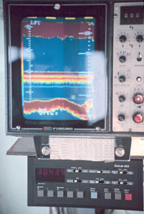
Display of a consumer type fishfinder Sport Fishfinder.jpg
Display of a consumer type fishfinder
Sonar image of a white bass feeding frenzy Whitebass.JPG
Sonar image of a white bass feeding frenzy

The image above, at right, clearly shows the bottom structure—plants, sediments and hard bottom are discernible on sonar plots of sufficiently high power and appropriate frequency. Slightly more than halfway up from the bottom to the left of the screen centre and about a third away from the left side, this image is also displaying a fish – a light spot just to the right of a 'glare' splash from the camera's flashbulb. The X-axis of the image represents time, oldest (and behind the soundhead) to the left, most recent bottom (and current location) on the right; thus the fish is now well behind the transducer, and the vessel is now passing over a dip in the ocean floor or has just left it behind. The resulting distortion depends on both the speed of the vessel and how often the image is updated by the echo sounder.

Fish arches

With the Fish Symbol feature disabled, an angler can learn to distinguish between fish, vegetation, schools of baitfish or forage fish, debris, etc. Fish will usually appear on the screen as an arch. This is because the distance between the fish and the transducer changes as the boat passes over the fish (or the fish swims under the boat). When the fish enters the leading edge of the sonar beam, a display pixel is turned on. As the fish swims toward the centre of the beam, the distance to the fish decreases, turning on pixels at shallower depths. When the fish swims directly under the transducer, it is closer to the boat so the stronger signal shows a thicker line. As the fish swims away from the transducer, the distance increases, which shows as progressively deeper pixels.

The image to the right shows a school of white bass aggressively feeding on a school of threadfin shad. Note the school of baitfish near the bottom. When threatened, baitfish form a tightly packed school, as the individuals seek safety in the center of the school. This typically looks like an irregularly shaped ball or thumbprint on the fishfinder screen. When no predators are nearby, a school of baitfish frequently appears as a thin horizontal line across the screen, at the depth where the temperature and oxygen levels are optimal. The nearly-vertical lines near the right edge of the screen show the path of fishing lures falling to the bottom.

General history in sporting and fishing

The first fishfinder that was marketed for consumers in America that was meant for recreational fishing was the Lowrance Fish Lo-K-Tor (also nicknamed "The Little Green Box") which was invented in 1957 and entered market in 1959. [5] [6] [7] It was not the first fishfinder, ie. sonar device meant to find underwater fish or schools of fish, as in 1948 in Japan the Furuno brothers introduced a fishfinder for use in commercial fishing vessels; this Furuno Fish Finder is said to be the world's first practical fishfinder. [8] The Fish Lo-K-Tor's operation was as described below (neon lamp readout device etc.).

By the early 1970s, a common pattern of depth finder used an ultrasonic transducer immersed in water, and an electromechanical readout device. A neon lamp mounted on the end of an arm was rotated around a circular scale at a fixed speed by a small electric motor. The circular scale was calibrated in terms of depth of water. The instrument was arranged to send out a pulse of ultrasonic waves as the lamp passed the zero point of the scale. The transducer was then arranged to detect any reflected ultrasound impulses; the lamp would flash when an echo returned to the transducer, and by its position on the scale would indicate the elapsed time and therefore the depth of the water. [9] These also gave a small flickering flash for echos off of fish. Like today's low-end digital fathometers, they kept no record of the depth over time and provided no information about bottom structure. They had poor accuracy, especially in rough water, and were hard to read in bright light. Despite the limitations, they were still usable for rough estimates of depth, such as for verifying that the boat had not drifted into an unsafe area.

Eventually, CRTs were married with a fathometer for commercial fishing and the fishfinder was born. With the advent of large LCD arrays, the high power requirements of a CRT gave way to the LCD in the early 1990s and fishfinding fathometers reached the sporting markets. Nowadays, many fishfinders available for hobby fishers have color LCD screens, built-in GPS, charting capabilities, and come bundled with transducers. Today, sporting fishfinders lack only the permanent record of the big ship navigational fathometer, and that is available in high end units that can use the ubiquitous computer to store that record as well.

Fishfinders may use higher frequencies to improve the image of underwater objects. [10] Side-looking transducers provide additional visibility of underwater objects on either side of the boat's path. [11]

Commercial and naval units

Commercial and naval fathometers of yesteryear used a strip chart recorder where an advancing roll of paper was marked by a stylus to make a permanent copy of the depth, usually with some means of also recording time (Each mark or time 'tic' is proportional to distance traveled) so that the strip charts could be readily compared to navigation charts and maneuvering logs (speed changes). Much of the world's ocean depths have been mapped using such recording strips. Fathometers of this type usually offered multiple (chart advance) speed settings, and sometimes, multiple frequencies as well. (Deep Ocean—Low Frequency carries better, Shallows—high frequency shows smaller structures (like fish, submerged reefs, wrecks, or other bottom composition features of interest.) At high frequency settings, high chart speeds, such fathometers give a picture of the bottom and any intervening large or schooling fish that can be related to position. Fathometers of the constant recording type are still mandated for all large vessels (100+ tons displacement) in restricted waters (i.e. generally, within 15 miles (24 km) of land).

The Furuno Fish Finder (the original from 1948) is said to be the world's first practical fishfinder; it was introduced by the Furuno brothers for use in commercial fishing vessels in 1948 in Japan. [8]

See also

Related Research Articles

<span class="mw-page-title-main">Sonar</span> Acoustic sensing method

Sonar is a technique that uses sound propagation to navigate, measure distances (ranging), communicate with or detect objects on or under the surface of the water, such as other vessels.

<span class="mw-page-title-main">Side-scan sonar</span> Tool for seafloor mapping

Side-scan sonar is a category of sonar system that is used to efficiently create an image of large areas of the sea floor.

<span class="mw-page-title-main">Echo sounding</span> Measuring the depth of water by transmitting sound waves into water and timing the return

Echo sounding or depth sounding is the use of sonar for ranging, normally to determine the depth of water (bathymetry). It involves transmitting acoustic waves into water and recording the time interval between emission and return of a pulse; the resulting time of flight, along with knowledge of the speed of sound in water, allows determining the distance between sonar and target. This information is then typically used for navigation purposes or in order to obtain depths for charting purposes.

<span class="mw-page-title-main">Hydrographic survey</span> Science of measurement and description of features which affect maritime activities

Hydrographic survey is the science of measurement and description of features which affect maritime navigation, marine construction, dredging, offshore wind farms, offshore oil exploration and drilling and related activities. Surveys may also be conducted to determine the route of subsea cables such as telecommunications cables, cables associated with wind farms, and HVDC power cables. Strong emphasis is placed on soundings, shorelines, tides, currents, seabed and submerged obstructions that relate to the previously mentioned activities. The term hydrography is used synonymously to describe maritime cartography, which in the final stages of the hydrographic process uses the raw data collected through hydrographic survey into information usable by the end user.

<span class="mw-page-title-main">Bathymetry</span> Study of underwater depth of lake or ocean floors

Bathymetry is the study of underwater depth of ocean floors, lake floors, or river floors. In other words, bathymetry is the underwater equivalent to hypsometry or topography. The first recorded evidence of water depth measurements are from Ancient Egypt over 3000 years ago. Bathymetric charts, are typically produced to support safety of surface or sub-surface navigation, and usually show seafloor relief or terrain as contour lines and selected depths (soundings), and typically also provide surface navigational information. Bathymetric maps may also use a Digital Terrain Model and artificial illumination techniques to illustrate the depths being portrayed. The global bathymetry is sometimes combined with topography data to yield a global relief model. Paleobathymetry is the study of past underwater depths.

(Acoustic homing) is the process in which a system uses the sound or acoustic signals of a target or destination to guide a moving object. There are two types of acoustic homing: passive acoustic homing and active acoustic homing. Objects using passive acoustic homing rely on detecting acoustic emissions produced by the target. Conversely, objects using active acoustic homing make use of sonar to emit a signal and detect its reflection off the target. The signal detected is then processed by the system to determine the proper response for the object. Acoustic homing is useful for applications where other forms of navigation and tracking can be ineffective. It is commonly used in environments where radio or GPS signals can not be detected, such as underwater.

An acoustic doppler current profiler (ADCP) is a hydroacoustic current meter similar to a sonar, used to measure water current velocities over a depth range using the Doppler effect of sound waves scattered back from particles within the water column. The term ADCP is a generic term for all acoustic current profilers, although the abbreviation originates from an instrument series introduced by RD Instruments in the 1980s. The working frequencies range of ADCPs range from 38 kHz to several megahertz.

A scientific echosounder is a device which uses sonar technology for the calibrated backscatter measurement of underwater physical and biological components—this device is also known as scientific sonar. Applications include bathymetry, substrate classification, studies of aquatic vegetation, fish, and plankton, and differentation of water masses.

<span class="mw-page-title-main">Multibeam echosounder</span> Type of sonar used to map the seabed

A multibeam echosounder (MBES) is a type of sonar that is used to map the seabed. It emits acoustic waves in a fan shape beneath its transceiver. The time it takes for the sound waves to reflect off the seabed and return to the receiver is used to calculate the water depth. Unlike other sonars and echo sounders, MBES uses beamforming to extract directional information from the returning soundwaves, producing a swathe of depth soundings from a single ping.

A depth finder may refer to any of the following:

<span class="mw-page-title-main">Underwater acoustics</span> Study of the propagation of sound in water

Underwater acoustics is the study of the propagation of sound in water and the interaction of the mechanical waves that constitute sound with the water, its contents and its boundaries. The water may be in the ocean, a lake, a river or a tank. Typical frequencies associated with underwater acoustics are between 10 Hz and 1 MHz. The propagation of sound in the ocean at frequencies lower than 10 Hz is usually not possible without penetrating deep into the seabed, whereas frequencies above 1 MHz are rarely used because they are absorbed very quickly.

<span class="mw-page-title-main">Ultrasonic transducer</span> Acoustic sensor

Ultrasonic transducers and ultrasonic sensors are devices that generate or sense ultrasound energy. They can be divided into three broad categories: transmitters, receivers and transceivers. Transmitters convert electrical signals into ultrasound, receivers convert ultrasound into electrical signals, and transceivers can both transmit and receive ultrasound.

Navico is a marine electronics company providing navigation, marine instruments and fish finding equipment to both the recreational and commercial marine sectors.

Geophysical MASINT is a branch of Measurement and Signature Intelligence (MASINT) that involves phenomena transmitted through the earth and manmade structures including emitted or reflected sounds, pressure waves, vibrations, and magnetic field or ionosphere disturbances.

<span class="mw-page-title-main">Fisheries acoustics</span>

Fisheries acoustics includes a range of research and practical application topics using acoustical devices as sensors in aquatic environments. Acoustical techniques can be applied to sensing aquatic animals, zooplankton, and physical and biological habitat characteristics.

<span class="mw-page-title-main">Depth sounding</span> Measuring the depths of a body of water

Depth sounding, often simply called sounding, is measuring the depth of a body of water. Data taken from soundings are used in bathymetry to make maps of the floor of a body of water, such as the seabed topography.

<span class="mw-page-title-main">Fessenden oscillator</span> Type of electro-acoustic transducer

A Fessenden oscillator is an electro-acoustic transducer invented by Reginald Fessenden, with development starting in 1912 at the Submarine Signal Company of Boston. It was the first successful acoustical echo ranging device. Similar in operating principle to a dynamic voice coil loudspeaker, it was an early kind of transducer, capable of creating underwater sounds and of picking up their echoes.

A sound velocity probe is a device that is used for measuring the speed of sound, specifically in the water column, for oceanographic and hydrographic research purposes.

<span class="mw-page-title-main">Deeper Fishfinder</span> Fish sonar produced in Lithuania

Deeper Smart Sonar is a wireless, castable echo-sounder compatible with iOS and Android smartphones and tablets. Wi-Fi connection enabled to maximize both the distance between the sounder and the device holder up to 330 ft / 100 m and the depth range up to 260 ft / 80 m. The scanning frequency allows the device to capture fast-moving objects and the scanning resolution measures small objects.

<span class="mw-page-title-main">Underwater survey</span> Inspection or measurement in or of an underwater environment

An underwater survey is a survey performed in an underwater environment or conducted remotely on an underwater object or region. Survey can have several meanings. The word originates in Medieval Latin with meanings of looking over and detailed study of a subject. One meaning is the accurate measurement of a geographical region, usually with the intention of plotting the positions of features as a scale map of the region. This meaning is often used in scientific contexts, and also in civil engineering and mineral extraction. Another meaning, often used in a civil, structural, or marine engineering context, is the inspection of a structure or vessel to compare actual condition with the specified nominal condition, usually with the purpose of reporting on the actual condition and compliance with, or deviations from, the nominal condition, for quality control, damage assessment, valuation, insurance, maintenance, and similar purposes. In other contexts it can mean inspection of a region to establish presence and distribution of specified content, such as living organisms, either to establish a baseline, or to compare with a baseline.

References

  1. Hodges, Richard P. (2013). Underwater Acoustics: Analysis, Design and Performance of Sonar. Hoboken, N.J.: John Wiley & Sons. ISBN   9781119957492 . Retrieved 4 July 2016.
  2. Everett V. Richardson, Peter F. Lagasse (1 January 1999). Stream Stability and Scour at Highway Bridges. ASCE Publications. p. 515. ISBN   0784474656 . Retrieved 1 March 2015.
  3. Editing Board. "Fish-finder". Encyclopædia Britannica . Retrieved 4 July 2016.
  4. Jackson, Darrell; Richardson, Michael (2007). High-frequency seafloor acoustics (1. ed.). New York: Springer. p. 458. ISBN   978-0387369457.
  5. "Lowrance's Fish-Lo-K-Tor, the good old days?". 13 March 2006.
  6. "About Lowrance Electronics | Lowrance".
  7. "60 Years of Lowrance".
  8. 1 2 "Fish Finders Point the Way for Future Fishing | April 2018 | Highlighting Japan".
  9. Conrad Miller, "Black Box Boating - Electronics For Power and Sail",Motor Boating, May 1970, page
  10. "Answers to Your Top Fish Finder Questions". Sport Fishing Magazine. 17 April 2018. Retrieved 2020-05-23.
  11. Neuman, Scott (26 September 2013). "What's Lurking In Your Lake? Sonar Turns Up Startling Finds". NPR.org. Retrieved 2020-05-23.