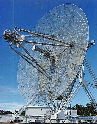
Radar is a system that uses radio waves to determine the distance (ranging), direction, and radial velocity of objects relative to the site. It is a radiodetermination method used to detect and track aircraft, ships, spacecraft, guided missiles, motor vehicles, map weather formations, and terrain.

Sonar is a technique that uses sound propagation to navigate, measure distances (ranging), communicate with or detect objects on or under the surface of the water, such as other vessels.

A Doppler radar is a specialized radar that uses the Doppler effect to produce velocity data about objects at a distance. It does this by bouncing a microwave signal off a desired target and analyzing how the object's motion has altered the frequency of the returned signal. This variation gives direct and highly accurate measurements of the radial component of a target's velocity relative to the radar. The term applies to radar systems in many domains like aviation, police radar detectors, navigation, meteorology, etc.
A pulse-Doppler radar is a radar system that determines the range to a target using pulse-timing techniques, and uses the Doppler effect of the returned signal to determine the target object's velocity. It combines the features of pulse radars and continuous-wave radars, which were formerly separate due to the complexity of the electronics.

Continuous-wave radar is a type of radar system where a known stable frequency continuous wave radio energy is transmitted and then received from any reflecting objects. Individual objects can be detected using the Doppler effect, which causes the received signal to have a different frequency from the transmitted signal, allowing it to be detected by filtering out the transmitted frequency.
Passive radar is a class of radar systems that detect and track objects by processing reflections from non-cooperative sources of illumination in the environment, such as commercial broadcast and communications signals. It is a specific case of bistatic radar – passive bistatic radar (PBR) – which is a broad type also including the exploitation of cooperative and non-cooperative radar transmitters.

Real-time kinematic positioning (RTK) is the application of surveying to correct for common errors in current satellite navigation (GNSS) systems. It uses measurements of the phase of the signal's carrier wave in addition to the information content of the signal and relies on a single reference station or interpolated virtual station to provide real-time corrections, providing up to centimetre-level accuracy. With reference to GPS in particular, the system is commonly referred to as carrier-phase enhancement, or CPGPS. It has applications in land surveying, hydrographic surveying, and in unmanned aerial vehicle navigation.
An acoustic doppler current profiler (ADCP) is a hydroacoustic current meter similar to a sonar, used to measure water current velocities over a depth range using the Doppler effect of sound waves scattered back from particles within the water column. The term ADCP is a generic term for all acoustic current profilers, although the abbreviation originates from an instrument series introduced by RD Instruments in the 1980s. The working frequencies range of ADCPs range from 38 kHz to several megahertz.
Pseudo-range multilateration, often simply multilateration (MLAT) when in context, is a technique for determining the position of an unknown point, such as a vehicle, based on measurement of biased times of flight (TOFs) of energy waves traveling between the vehicle and multiple stations at known locations. TOFs are biased by synchronization errors in the difference between times of arrival (TOA) and times of transmission (TOT): TOF=TOA-TOT. Pseudo-ranges (PRs) are TOFs multiplied by the wave propagation speed: PR=TOF ⋅ s. In general, the stations' clocks are assumed synchronized but the vehicle's clock is desynchronized.

Acoustic location is a method of determining the position of an object or sound source by using sound waves. Location can take place in gases, liquids, and in solids.
In land warfare, artillery sound ranging is a method of determining the coordinates of a hostile battery using data derived from the sound of its guns firing, so called target acquisition.

Ocean acoustic tomography is a technique used to measure temperatures and currents over large regions of the ocean. On ocean basin scales, this technique is also known as acoustic thermometry. The technique relies on precisely measuring the time it takes sound signals to travel between two instruments, one an acoustic source and one a receiver, separated by ranges of 100–5,000 kilometres (54–2,700 nmi). If the locations of the instruments are known precisely, the measurement of time-of-flight can be used to infer the speed of sound, averaged over the acoustic path. Changes in the speed of sound are primarily caused by changes in the temperature of the ocean, hence the measurement of the travel times is equivalent to a measurement of temperature. A 1 °C (1.8 °F) change in temperature corresponds to about 4 metres per second (13 ft/s) change in sound speed. An oceanographic experiment employing tomography typically uses several source-receiver pairs in a moored array that measures an area of ocean.
A radar system uses a radio-frequency electromagnetic signal reflected from a target to determine information about that target. In any radar system, the signal transmitted and received will exhibit many of the characteristics described below.

Underwater acoustics is the study of the propagation of sound in water and the interaction of the mechanical waves that constitute sound with the water, its contents and its boundaries. The water may be in the ocean, a lake, a river or a tank. Typical frequencies associated with underwater acoustics are between 10 Hz and 1 MHz. The propagation of sound in the ocean at frequencies lower than 10 Hz is usually not possible without penetrating deep into the seabed, whereas frequencies above 1 MHz are rarely used because they are absorbed very quickly.

Ultrasonic transducers and ultrasonic sensors are devices that generate or sense ultrasound energy. They can be divided into three broad categories: transmitters, receivers and transceivers. Transmitters convert electrical signals into ultrasound, receivers convert ultrasound into electrical signals, and transceivers can both transmit and receive ultrasound.

Coastal ocean dynamics applications radar (CODAR) is a type of portable, land-based, high frequency (HF) radar developed between 1973 and 1983 at NOAA's Wave Propagation Laboratory in Boulder, Colorado. CODAR is a noninvasive system that can measure and map near-surface ocean currents in coastal waters. It is transportable and can produce ocean current maps on site in near real time. Moreover, using CODAR it is possible to measure wave heights and produce an indirect estimate of local wind direction.
Time of arrival is the absolute time instant when a radio signal emanating from a transmitter reaches a remote receiver. The time span elapsed since the time of transmission is the time of flight . Time difference of arrival (TDOA) is the difference between TOAs.

Radio is the technology of communicating using radio waves. Radio waves are electromagnetic waves of frequency between 3 hertz (Hz) and 300 gigahertz (GHz). They are generated by an electronic device called a transmitter connected to an antenna which radiates oscillating electrical energy, often characterized as a wave. They can be received by other antennas connected to a radio receiver; this is the fundamental principle of radio communication. In addition to communication, radio is used for radar, radio navigation, remote control, remote sensing, and other applications.
RAFOS floats are submersible devices used to map ocean currents well below the surface. They drift with these deep currents and listen for acoustic "pongs" emitted at designated times from multiple moored sound sources. By analyzing the time required for each pong to reach a float, researchers can pinpoint its position by trilateration. The floats are able to detect the pongs at ranges of hundreds of kilometers because they generally target a range of depths known as the SOFAR channel, which acts as a waveguide for sound. The name "RAFOS" derives from the earlier SOFAR floats, which emitted sounds that moored receivers picked up, allowing real-time underwater tracking. When the transmit and receive roles were reversed, so was the name: RAFOS is SOFAR spelled backward. Listening for sound requires far less energy than transmitting it, so RAFOS floats are cheaper and longer lasting than their predecessors, but they do not provide information in real-time: instead they store it on board, and upon completing their mission, drop a weight, rise to the surface, and transmit the data to shore by satellite.

In virtual reality (VR) and augmented reality (AR), a pose tracking system detects the precise pose of head-mounted displays, controllers, other objects or body parts within Euclidean space. Pose tracking is often referred to as 6DOF tracking, for the six degrees of freedom in which the pose is often tracked.
