Sonar is a technique that uses sound propagation to navigate, measure distances (ranging), communicate with or detect objects on or under the surface of the water, such as other vessels. Two types of technology share the name "sonar": passive sonar is essentially listening for the sound made by vessels; active sonar is emitting pulses of sounds and listening for echoes. Sonar may be used as a means of acoustic location and of measurement of the echo characteristics of "targets" in the water. Acoustic location in air was used before the introduction of radar. Sonar may also be used for robot navigation, and SODAR is used for atmospheric investigations. The term sonar is also used for the equipment used to generate and receive the sound. The acoustic frequencies used in sonar systems vary from very low (infrasonic) to extremely high (ultrasonic). The study of underwater sound is known as underwater acoustics or hydroacoustics.

Side-scan sonar is a category of sonar system that is used to efficiently create an image of large areas of the sea floor.

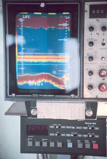
Echo sounding or depth sounding is the use of sonar for ranging, normally to determine the depth of water (bathymetry). It involves transmitting acoustic waves into water and recording the time interval between emission and return of a pulse; the resulting time of flight, along with knowledge of the speed of sound in water, allows determining the distance between sonar and target. This information is then typically used for navigation purposes or in order to obtain depths for charting purposes.

Hydrographic survey is the science of measurement and description of features which affect maritime navigation, marine construction, dredging, offshore oil exploration/offshore oil drilling and related activities. Strong emphasis is placed on soundings, shorelines, tides, currents, seabed and submerged obstructions that relate to the previously mentioned activities. The term hydrography is used synonymously to describe maritime cartography, which in the final stages of the hydrographic process uses the raw data collected through hydrographic survey into information usable by the end user.

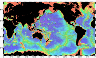
Bathymetry is the study of underwater depth of ocean floors, lake floors, or river floors. In other words, bathymetry is the underwater equivalent to hypsometry or topography. The first recorded evidence of water depth measurements are from Ancient Egypt over 3000 years ago. Bathymetric charts are typically produced to support safety of surface or sub-surface navigation, and usually show seafloor relief or terrain as contour lines and selected depths (soundings), and typically also provide surface navigational information. Bathymetric maps may also use a Digital Terrain Model and artificial illumination techniques to illustrate the depths being portrayed. The global bathymetry is sometimes combined with topography data to yield a global relief model. Paleobathymetry is the study of past underwater depths.

Hydroacoustics is the study and application of sound in water. Hydroacoustics, using sonar technology, is most commonly used for monitoring of underwater physical and biological characteristics.
A scientific echosounder is a device which uses sonar technology for the measurement of underwater physical and biological components—this device is also known as scientific sonar. Applications include bathymetry, substrate classification, studies of aquatic vegetation, fish, and plankton, and differentation of water masses.

A multibeam echosounder is a type of sonar that is used to map the seabed. Like other sonar systems, multibeam systems emit acoustic waves in a fan shape beneath the transceiver of the multibeam echosounder. The length of time it takes for the sound waves to reflect off the seabed and return to the receiver is used to calculate the water depth. Unlike other sonars, multibeam systems use beamforming to extract directional information from the returning soundwaves, producing a swath of depth readings from a single ping.

Dr. Fred Noel Spiess was a naval officer, oceanographer and marine explorer. His work created new advances in marine technology including the FLIP Floating Instrument Platform, the Deep Tow vehicle for study of the seafloor, and the use of acoustics for underwater navigation and geodetic positioning.

NOAA Ship Fairweather, originally operated by the United States Coast and Geodetic Survey as USC&GS Fairweather, is an oceanographic research ship operated by the National Oceanic and Atmospheric Administration (NOAA). Fairweather primarily conducts hydrographic surveys in Alaskan waters, but is considered a multi-mission-capable vessel and has conducted fisheries research cruises. She is the sister ship of the NOAAS Rainier and of the retired NOAAS Mount Mitchell.
Geophysical MASINT is a branch of Measurement and Signature Intelligence (MASINT) that involves phenomena transmitted through the earth and manmade structures including emitted or reflected sounds, pressure waves, vibrations, and magnetic field or ionosphere disturbances.
Pockmarks are concave, crater-like depressions on seabeds that are caused by fluids escaping and erupting through the seafloor. They can vary in size and have been found worldwide.

Fisheries acoustics includes a range of research and practical application topics using acoustical devices as sensors in aquatic environments. Acoustical techniques can be applied to sensing aquatic animals, zooplankton, and physical and biological habitat characteristics.

The Sirena Deep, originally named the HMRG Deep, was discovered in 1997 by a team of scientists from Hawaii. Its directly measured depth of 10,714 m (35,151 ft) is third only to the Challenger Deep and Horizon Deep, currently the deepest known directly measured places in the ocean. It lies along the Mariana Trench, 200 kilometers to the east of the Challenger Deep and 145 km south of Guam.
The HAWAII MR1 is a seafloor imaging system developed by the Hawaii Mapping Research Group (HMRG) in 1991. HAWAII MR1 is short for HIGP Acoustic Wide Angle Imaging Instrument, Mapping Researcher 1. This system is the first to use all-digital signal processing. It has been used in the discovery of several objects and locations of note, examples being the USS Yorktown and the HMRG Deep.

NOAAS Whiting, was an American survey ship that was in commission in the National Oceanic and Atmospheric Administration (NOAA) from 1970 to 2003. Previously, she had been in commission in the United States Coast and Geodetic Survey from 1963 to 1970 as USC&GS Whiting.
The RV Denar 2 is a Turkish research and survey vessel owned by TOMA Maritime S.A. Istanbul, Turkey and operated 2E Maritime in Istanbul, Turkey.

Seafloor mapping, also called seafloor imaging, is the measurement, mapping, and imaging of water depth of the ocean or another given body of water. Bathymetric measurements are conducted with various methods, from depth sounding, sonar and Lidar techniques, to buoys and satellite altimetry. Various methods have advantages and disadvantages and the specific method used depends upon the scale of the area under study, financial means, desired measurement accuracy, and additional variables. Despite modern computer-based research, the ocean seabed in many locations is less measured than the topography of Mars.

Remote sensing in geology is remote sensing used in the geological sciences as a data acquisition method complementary to field observation, because it allows mapping of geological characteristics of regions without physical contact with the areas being explored. About one-fourth of the Earth's total surface area is exposed land where information is ready to be extracted from detailed earth observation via remote sensing. Remote sensing is conducted via detection of electromagnetic radiation by sensors. The radiation can be naturally sourced, or produced by machines and reflected off of the Earth surface. The electromagnetic radiation acts as an information carrier for two main variables. First, the intensities of reflectance at different wavelengths are detected, and plotted on a spectral reflectance curve. This spectral fingerprint is governed by the physio-chemical properties of the surface of the target object and therefore helps mineral identification and hence geological mapping, for example by hyperspectral imaging. Second, the two-way travel time of radiation from and back to the sensor can calculate the distance in active remote sensing systems, for example, Interferometric synthetic-aperture radar. This helps geomorphological studies of ground motion, and thus can illuminate deformations associated with landslides, earthquakes, etc.
In hydrography, the Navigation Surface paradigm represents an alternative to traditional approaches to manage bathymetric data by creating bathymetric databases that can be used to generate high-resolution navigation aids and other applications.


