Malappuram, is one of the 14 districts in the Indian state of Kerala, with a coastline of 70 km (43 mi). The most populous district of Kerala, Malappuram is home to around 13% of the total population of the state. The district was formed on 16 June 1969, spanning an area of about 3,554 km2 (1,372 sq mi). It is the third-largest district of Kerala by area. It is bounded by Western Ghats and the Arabian Sea on either side. The district is divided into seven Taluks: Eranad, Kondotty, Nilambur, Perinthalmanna, Ponnani, Tirur, and Tirurangadi.
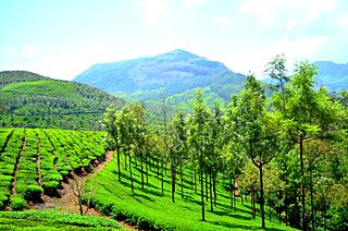
Munnar is a town and hill station located in the Idukki district of the southwestern Indian state of Kerala. Munnar is situated at around 1,600 metres (5,200 ft) above mean sea level, in the Western Ghats mountain range. Munnar is also called the "Kashmir of South India" and is a popular honeymoon destination.

Palakkad is one of the 14 districts in the Indian state of Kerala. It was carved out of the southeastern region of the former Malabar District on 1 January 1957. It is located at the central region of Kerala and is the second largest district in the state after Idukki. The city of Palakkad is the district headquarters. Palakkad is bordered on the northwest by the Malappuram district, on the southwest by the Thrissur district, on the northeast by Nilgiris district, and on the east by Coimbatore district of Tamil Nadu. The district is nicknamed "The granary of Kerala". Palakkad is the gateway to Kerala due to the presence of the Palakkad Gap, in the Western Ghats. The 2,383 m high Anginda peak, which is situated in the border of Palakkad district, Nilgiris district, and Malappuram district, in Silent Valley National Park, is the highest point of elevation in Palakkad district. Palakkad city is about 347 kilometres (216 mi) northeast of the state capital, Thiruvananthapuram.
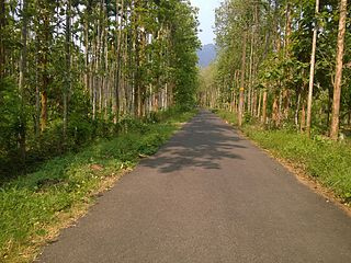
Nilambur is a major town, a municipality and a Taluk in the Malappuram district of the Indian state of Kerala. It is located close to the Nilgiris range of the Western Ghats on the banks of the Chaliyar River. This place is also known as 'Teak Town' because of the abundance of Nilambur teaks, which is a variety of a large, deciduous tree that occurs in mixed hardwood forests. Unlike many Municipalities of India; Nilambur is covered with large amounts of vegetation, making it very scenic.

Chaliyar River is the fourth longest river in Kerala at 169 km in length. The Chaliyar is also known as Chulika River, Nilambur River or Beypore River as it is near the sea. Pothukal, Chungathara, Nilambur, Mampad, Edavanna, Kavanoor, Perakamanna, Areekode, Kizhuparamba, Elamaram, Cheekkode, Vazhakkad, Vazhayur, Cheruvadi, Edavannappara, Mavoor, Peruvayal, Feroke and Beypore are some of the towns/villages situated along the banks of the Chaliyar. It mainly flows through Malappuram district. Its tributaries flow through both the districts of Malappuram and Kozhikode. The bank of river Chaliyar in the Nilambur region is also known for its natural Gold fields. Explorations done at the valley of the river Chaliyar in Nilambur have shown reserves of the order of 2.5 million cubic meters of placers with 0.1 gram per cubic meter of gold. It originates at the Ilambaleri hills of Nilgiri Mountains in Nilgiris district, which is also near Wayanad-Malappuram district border. It flows mainly through the erstwhile region of Eranad, and finally empties into the Arabian Sea at Beypore port, opposite to Chaliyam harbour.

Mannarkkad, formerly known as Mannarghat, is a major municipal town in Palakkad district of the Indian state of Kerala. The Silent Valley National Park and the Attappadi Reserve Forest are located in Mannarkkad Taluk. Mannarkkad is situated 36 km away from district headquarters Palakkad on National Highway 966. It is the traditional seat of the Mannarghat Moopil Nair.
Munderi is a small village in Nilambur Taluk of Malappuram District, in Kerala. It got the name from "Mount Area" as it is surrounded by mountain ranges. The un-tarred forest road from Munderi towards North through forests lead to Chooralmala in Wayanad district.
Kalikavu is a town in Nilambur taluk of Malappuram district in Kerala state, South India. Like the neighbouring town of Nilambur, Kalikavu is also known for rubber plantation. Coconut, pepper, arecanut, and teak are also cultivated here.

Mukurthi Peak is one of the highest peaks in the Western Ghats, situated on the border of Udagamandalam taluk, Nilgiris, Tamil Nadu, Nilambur taluk, Malappuram, and Kerala in India. It reaches an altitude of 2,554 m (8,379ft), and is the fifth-highest peak in South India.

Vaniyambalam lies in Nilambur taluk in the Malappuram district, Kerala and is 40 km north-east of Malappuram. Surrounding towns include Pandikkad and Tuvvur, Kalikavu, and Wandoor and Nilambur.

Karuvarakundu is a semi-urban area in the eastern part of Malappuram district, Kerala, India. It is situated 32 kilometres (20 mi) east of Manjeri, 26 kilometres (16 mi) northeast of Perinthalmanna and 30 km southeast of Nilambur. The Olippuzha River, a tributary of the Kadalundipuzha, flows through the town. Karuvarakundu is close to the Western Ghats and hence prone to landslides.

The Nilambur–Shoranur line is a 66 kilometres (41 mi)-long single-line, electrified broad-gauge (1676 mm) railway spur branch line of the Indian Railways connecting Nilambur Road railway station in Malappuram district with Shoranur Junction in Palakkad district in the state of Kerala. It is a branch line administered by the Palakkad railway division of the Southern Railway zone and one of the shortest broad-gauge railway lines in India. It was laid by the British in the colonial era for the transportation of Nilambur Teak logs to the United Kingdom through Kozhikode. The line is electrified and was inspected by railway officials from Southern Railway on 30 March 2024. With this, the Palakkad division achieved 100% electrification.
Pothukallu (Pothukal) is located between Palunda and Munderi. Pothukallu is well known for its greenery, hospitality of the natives, and availability of all basic amenities, including schools, hospitals, shopping centers etc. There is a police station,forest station, mosque, church, and temple at nearby locations. Pothukallu is located at the boundary of three districts namely, Wayanad and Malappuram of Kerala state and The Nilgiris of Tamil Nadu.

The Kerala Forest Research Institute (KFRI) is an organisation based in Peechi, in Thrissur, India. It was established in 1975 by the Government of Kerala as part of its Science and Technology Department, and in 2003 became part of the KSCSTE.
Eranad also known as Ernad refers to the erstwhile province in the midland area of Malabar, consisting of Malappuram and nearby regions such as Anakkayam, Manjeri, Kondotty, Nilambur, etc. Currently Eranad Taluk is a Taluk in Malappuram district. Eranad was ruled by a Samanthan Nair clan known as Eradis, similar to the Vellodis of neighbouring Valluvanad and Nedungadis of Nedunganad. The rulers of Eranad were known by the title Eralppad/Eradi. They also used the title Thirumulpad.

Nilambur Kovilakam, also known as Nilambur Kingdom or Nilambapuri, was a former vassal kingdom and royal Kovilakam in present-day Kerala, India, situated near to the Nilgiri range of the Western Ghats. It was ruled by Samantha Kshatriyas who were the family members and representatives of the Samoothiri (Zamorin), and also established marriage relations with the Nambudiris. They served as vassal kings to the Zamorin, with their capital located 25 kilometers north of Manjeri in present-day Malappuram district. They built several aristocratic Tharavads, such as the Nambudiri tharavad of Pootheri Illam in Feroke, and married into the Zamorin's own family from Nediyiruppu Swaroopam.

Perinthalmanna is a major town and municipality in Malappuram district, Kerala, India. It serves as the administrative centre for the Perinthalmanna taluk, as well as a revenue division, a community development block, and a police sub-division bearing the same name. It was formerly the headquarters of Valluvanad Taluk, which was one of the two Taluks in the Malappuram Revenue Division of the erstwhile Malabar District during the British Raj. The city is located 23 kilometres (14 mi) southwest of the city of Malappuram at the centre of the Kozhikode–Malappuram–Perinthalmanna–Palakkad National Highway 966.
Thandukode is a village beside Madumala in Kalikavu Panchayat, Nilambur taluk in Malappuram district in the state of Kerala. The village consists of an LP school, Madrassa, temple and mosques. Political activities are very active; the leading parties are IUML, Congress and CPI (M). Popular religious organisations are Wisdom Youth, SKSSF, SSF.
Valenchery is a small town in Morayur Gram panchayat in Malappuram in Malappuram district of state of Kerala. Valenchery is divided into four Areas, they are Village Road, Colony Road, Madrasa Road and Hilltop Area.Four Wards from Morayur Panchayath partly belongs to Valenchery. Nearest places are Valluvambram Junction, Mongam, Morayur, Arimbra and Pookkottur. Nearest tourist spot is Mini Ooty.

South Malabar refers to a geographical area of the southwestern coast of India covering some parts of the present-day Kerala state. South Malabar covers the regions included in present-day Kozhikode taluk of Kozhikode district, the whole area of Malappuram district, Chavakkad taluk of Thrissur district, and Palakkad district, excluding parts of Chittur taluk. The Fort Kochi region of Kochi city also historically belongs to South Malabar. The term South Malabar refers to the region of the erstwhile Malabar District south to the river Korapuzha, and bears a high cultural similarity to both the Cochin and the North Malabar regions.