Related Research Articles

Idukki is one of the 14 districts in the Indian state of Kerala in the southwest of the country. It is the largest district in Kerala and lies amid the Cardamom Hills of Western Ghats in Kerala. Idukki district contains two municipal towns - Kattappana and Thodupuzha, and five taluks.

Muvattupuzha is a town, municipality in the midlands directly to the east of Kochi in Ernakulam district, Kerala, India. It is located about 36 km (22 mi) from downtown Kochi, and is a growing urban centre in central Kerala. The town is also the starting point of the Muvattupuzhayar, which is a confluence formed by three rivers: the Thodupuzhayar, Kaliyar, and Kothayar.

New Bullards Bar Dam is a variable radius concrete arch dam constructed in the early 1960s in California on the North Yuba River. Located near the town of Dobbins in Yuba County, the dam forms the New Bullards Bar Reservoir, which can hold about 969,600 acre⋅ft (1.1960×10⁹ m3) of water. The dam serves for irrigation, drinking water and hydroelectric power generation.

Periyar, IPA:[peɾijɐːr], is the longest river and the river with the largest discharge potential in the Indian state of Kerala. It is one of the few perennial rivers in the region and provides drinking water for several major towns. The Periyar is of utmost significance to the economy of Kerala. It generates a significant proportion of Kerala's electrical power via the Idukki Dam and flows along a region of industrial and commercial activity. The river also provides water for irrigation and domestic use throughout its course besides supporting a rich fishery. Due to these reasons, the river has been named the "Lifeline of Kerala". Kochi city, in the vicinity of the river mouth, draws its water supply from Aluva, an upstream site sufficiently free of seawater intrusion. Twenty five percent of Kerala's industries are along the banks of the Periyar. These are mostly crowded within a stretch of 5 kilometres (3 mi) in the Eloor-Edayar region (Udhyogamandal), about 10 kilometres (6 mi) north of Kochi harbor.

The Anamala or Anaimalai, also known as the Elephant Mountains, are a range of mountains in the southern Western Ghats of central Kerala and span the border of western Tamil Nadu in Southern India. The name anamala is derived from the Malayalam word aana and the Tamil word yaanai, meaning elephant, or from tribal languages. Mala or Malai means 'mountain', and thus literally translatable as 'Elephant mountain'.

The Idukki Dam is a double-curvature arch dam constructed across the Periyar River in a narrow gorge between two granite hills locally known as Kuravan and Kurathi in Idukki district in the state of Kerala, India. It is constructed and owned by the Kerala State Electricity Board. It supports a 780 MW hydroelectric power station in Moolamattom, which started generating power on 4 October 1975. At 168.91 metres (554.2 ft), it is one of the highest arch dams in Asia. The Indo-Canadian project was inaugurated by the Prime Minister Indira Gandhi on February 17, 1976.
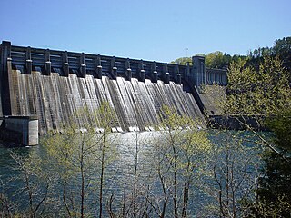
Norfork Dam is a large dam in northern Arkansas southeast of Mountain Home. It dams North Fork River and creates Norfork Lake. The top of the dam supports a 2-lane roadway, part of AR 177.

Cheruthoni is a town on the banks of Cheruthoni River, a major tributary of the Periyar River, the second longest river in Kerala state, in southwestern India. The area is known by Cheruthoni Dam, which is a part of Idukki reservoir, which provide hydroelectric power to the region.
Mullaperiyar Dam is a masonry gravity dam on the Periyar River of Idukki district of Indian state of Kerala. It is situated 150km south east of Kochi. It is located 881 m (2,890 ft) above the sea level, on the Cardamom Hills of the Western Ghats in Thekkady, Idukki District of Kerala, India. It was constructed between 1887 and 1895 by John Pennycuick and also reached in an agreement to divert water eastwards to the Madras Presidency area. It has a height of 53.6 m (176 ft) from the foundation, and a length of 365.7 m (1,200 ft). The Periyar National Park in Thekkady is located around the dam's reservoir. The dam is built at the confluence of Mullayar and Periyar rivers. The dam is located in Kerala on the river Periyar, but is operated and maintained by the neighbouring state of Tamil Nadu. Although the Periyar River has a total catchment area of 5398 km2 with 114 km2 downstream from the dam in Tamil Nadu, the catchment area of the Mullaperiyar Dam itself lies entirely in Kerala and thus not an inter-State river. On 21 November 2014, the water level hit 142 feet for first time in 35 years. The reservoir again hit the maximum limit of 142 feet on 15 August 2018, following incessant rains in the state of Kerala. In a UN report published in 2021, the dam was identified as one among the world's big dams which needs to be decommissioned for being 'situated in a seismically active area with significant structural flaws and poses risk to 3.5 million people if the 100+ years old dam were to fail'.

Ramakkalmedu is a hill station and a hamlet in Idukki district in the Indian state of Kerala. The place is noted for its panoramic beauty and numerous windmills.
Moolamattom is the headquarters of Arakulam Panchayath in Thodupuzha Taluk, Idukki district in Kerala, India. It lies 22 km from Thodupuzha, on the banks of the Thodupuzha River, a tributary of the Muvattupuzha river. Moolamattom is famous for India's second largest underground hydroelectric power station - Moolamattom hydro power station.

Ilaveezhapoonchira is a tourist destination located in Melukavu village in Kottayam district near Kanjar. Ilaveezha Poonchira is surrounded by three enchanting hillocks - Mankunnu, Kodayathoormala and Thonippara. This makes the place ideal for trekking.

Muttom is a rural area in Idukki district in the Indian state of Kerala. This place is 66 km away from Cochin. Geographically this place is part of Midland or Idanad region of Kerala.
The Kuravar is an ethnic Tamil community native to the Kurinji mountain region of TamilNadu and Kerala, India.

The Cheruthoni Dam, located in Idukki District, Kerala, India, is a 138m tall concrete gravity dam. Preliminary work on this project was initiated under the leadership of Superintending Engineer, E.U.Philipose. This dam was constructed in 1976 as part of the Idukki Hydroelectric Project along with two other dams Idukki and Kulamavu. The Canadian government aided the project with long-term loans and grants. The dam was constructed by HCC and the consultant was S.N.C. Inc., Canada,

Malankara dam is a gravity dam constructed across Thodupuzha river for irrigation purposes. The dam is constructed to make use of the tail water from the Moolamattom power house. The project is run under the Muvattupuzha Valley Irrigation Project and KSEB. The artificial lake covers an area of around 11 square km.

The KDHP Tea Museum is an industry and history museum situated in Munnar, a town in the Idukki district of Kerala in South India. Tata Tea Museum is its official name, but it's also known as Nullathanni Estate where it is located, or Kannan Devan Hills Plantation (KDHP) Tea Museum.

Kulamavu Dam is a gravity/masonry dam on Kilivillithode, which is a tributary of the Periyar river in Arakkulam village, Idukki district in the Indian state of Kerala. It is one of three dams associated with the Idukki hydro electric power project in the Indian state of Kerala. This dam is located towards the western side of the Idukki Arch Dam. This is a gravity dam with the top portion in concrete and the bottom in masonry.

Anayirangal Dam (Malayalam: ആനയിറങ്കൽ അണക്കെട്ട്) is an earthen dam built on the Panniyar river in Chinnakanal and Santhanpara panchayats, 22 km (14 mi) from Munnar in Idukki district of Kerala, India. The dam is surrounded on one side by forest and on the other by Tata Tea Plantation. The dam is located near the Munnar - Kumily road. The water flowing from the dam reaches Kuthungal and Ponmudi dams through the Panniyar river. Power is generated at Kuthungal and Panniyar powerhouses. The dam stores water from small streams flowing from Bealram and rainwater flowing from the hills on the Tamil Nadu border. The height of the dam is 34.14 metres (112.0 ft) and Length is 326.13 metres (1,070.0 ft). The reservoir usually fills up in June and July.
Vadakkepuzha Weir is a diversion dam of Earthen type constructed across Vadakkepuzha which is a tributary of Muvattupuzha river in Arakkulam village in Idukki district of Kerala, India. Vadakkepuzha weir is a part of an augmentation scheme for the Idukki Hydro Electric Project. Narakakkanam, Azhutha, Vazhikkadavu, Vadakkepuzha and Kuttiar diversion schemes were later added to Idukki HEP to augment the reservoir. Water from the reservoir is pumped in to Idukki reservoir through a pump house with three pumps.
References
- ↑ "Idukki Arch Dam". Idukki.nic.in. Idukki District Administration.
- ↑ "കുറവൻ– കുറത്തി കഥ, ഇടുക്കിയുടെയും; ഒരു ഐതിഹ്യ കഥയും പറയാനുണ്ട്..." Manorama Online. 2 January 2022.