
Periyar, is the longest river and the river with the largest discharge potential in the Indian state of Kerala. It is one of the few perennial rivers in the region and provides drinking water for several major towns. The Periyar is of utmost significance to the economy of Kerala. It generates a significant proportion of Kerala's electrical power via the Idukki Dam and flows along a region of industrial and commercial activity. The river also provides water for irrigation and domestic use throughout its course besides supporting a rich fishery. Due to these reasons, the river has been named the "Lifeline of Kerala". Kochi city, in the vicinity of the river mouth, draws its water supply from Aluva, an upstream site sufficiently free of seawater intrusion. Twenty five percent of Kerala's industries are along the banks of the Periyar. These are mostly crowded within a stretch of 5 kilometres (3 mi) in the Eloor-Edayar region (Udhyogamandal), about 10 kilometres (6 mi) north of Kochi harbor.
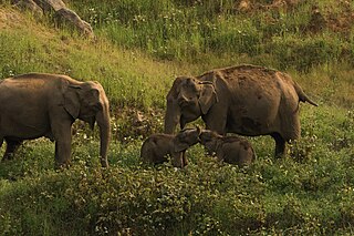
Anaimalai Tiger Reserve, earlier known as Indira Gandhi Wildlife Sanctuary and National Park and as Anaimalai Wildlife Sanctuary, is a protected area in the Anaimalai Hills of Pollachi and Valparai taluks of Coimbatore District and Udumalaipettai taluk in Tiruppur District, Tamil Nadu, India. The Tamil Nadu Environment and Forests Department by a notification dated 27 June 2007, declared an extent of 958.59 km2 that encompassed the erstwhile IGWLS&NP or Anaimalai Wildlife Sanctuary, as Anaimalai Tiger Reserve under the Wildlife Protection Act, 1972. According to the National Tiger Conservation Authority, the Reserve presently includes a core area of 958.59 km2 and buffer/peripheral area of 521.28 km2 forming a total area of 1479.87 km2.

Chalakudy is a municipal town situated on the banks of Chalakudy River in Thrissur district of the Kerala state in India. It is the headquarters of Chalakudy taluk. It is the base camp for travellers to Athirappilly Falls and Vazhachal Falls. Chalakudy lies on National Highway 544 and located about 47 km (23 mi) north of the city of Kochi, and 30 km (19 mi) south of Thrissur.

Chalakudy River or Chalakudy Puzha is the fifth longest river in Kerala, India. The river flows through Thrissur district, Palakkad district and Ernakulam district of Kerala. The total drainage area of the river is 1704 km2. Out of this, 1404 km2 lies in Kerala and the rest in Tamil Nadu. The length of the river is 145.5 km. Though Chalakudy River in strict geological sense is a tributary of the Periyar river, for all practical purposes it is treated as a separate river by Government and other agencies. The river has gained its name since it flows along the banks of the Chalakudy Town, the major settlement along the course of the river. It is perhaps the most unpolluted and pristine river in the state and even in India due to the limited amount of industries and wastage disposal around it. Chalakudy River and its basin area were one of the most affected rivers during the 2018 Kerala floods.

Coimbatore district is one of the 38 districts in the state of Tamil Nadu in India. Coimbatore is the administrative headquarters of the district. It is one of the most industrialized districts and a major textile, industrial, commercial, educational, information technology, healthcare and manufacturing hub of Tamil Nadu. The region is bounded by Tiruppur district in the east, Nilgiris district in the north, Erode district in the northeast, Palakkad district, Idukki district and small parts of Thrissur district and Ernakulam district of neighboring state of Kerala in the west and south respectively. As of 2011, Coimbatore district had a population of 3,458,045 with a sex ratio of 1,000 and literacy rate of 84%.
Pollachi is a town and municipality in Coimbatore district of the Indian state of Tamil Nadu. It is the administrative headquarters of Pollachi taluk. It is situated near the center of the South Indian Peninsula, surrounded by Western Ghats. Agriculture and textile industries contribute majorly to the economy of the town and the town is a popular marketplace for jaggery, vegetables and cattle.

Vazhachal Falls is situated in Athirappilly Panchayath of Thrissur district in Kerala on the southwest coast of India. Located on the west-flowing Chalakudy River near the Vazhachal Forest Division and at the edge of the Sholayar ranges, it is just 5 km from entrance of Athirappilly Falls. It is located 36 km from Chalakudy.

Valparai is a Taluk and hill station in the Coimbatore district of Tamil Nadu, India. It consists of Anamalai Tiger Reserve. It is located 3,474 feet (1,059 m) above sea level on the Anaimalai Hills range of the Western Ghats. There are a total of 56 estates here. The game of football is very popular here. State level competitions are held every year. The foothill starts exactly from Monkey Falls which is at a distance of 38 kilometres (24 mi) to Valparai. The route to Valparai from the foothills consists of 40 hairpin bends. The Kerala state border town of Malakkappara is at a distance of 27 kilometres from Valparai. While major portions of the land are owned by private tea companies, large forest areas continue to be out of bounds.
Athirappilly is a first grade Grama Panchayath with 489.00 km2 area in Chalakudy Taluk, Thrissur district in Kerala, India. It is located 60 km from Thrissur city, 70 km northeast of Kochi city, 55 km northeast of Cochin International Airport, and 30 km from Chalakudy town.

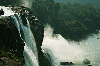
Athirapilly Falls is situated in Athirapilly Panchayat in Chalakudy Taluk of Thrissur District in Kerala, India on the Chalakudy River, which originates from the upper reaches of the Western Ghats at the entrance to the Sholayar ranges. It is the largest waterfall in Kerala, which stands tall at 81.5 feet. Just a short drive from Athirapilly is the Vazhachal Falls, which is close to dense green forests that are home to many endangered and endemic species of flora and fauna.
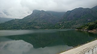
Aliyar Reservoir is a 6.48 km2 (2.5 sq mi) reservoir located in Aliyar village near Pollachi town in Coimbatore District, Tamil Nadu, South India. The dam is located in the foothills of Valparai, in the Anaimalai Hills of the Western Ghats. It is about 65 kilometres (40 mi) from Coimbatore. The dam offers some ideal getaways including a park, garden, aquarium, play area and a mini Theme-Park maintained by Tamil Nadu Fisheries Corporation for visitors enjoyment. The scenery is beautiful, with mountains surrounding three quarters of the reservoir. Boating is also available.

Monkey Falls are natural waterfalls located near the uphill ghat road Valparai on the Pollachi-Valparai road in the Anaimalai Hills range, in Coimbatore district.

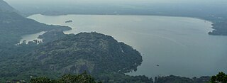
Solaiyar Dam, Upper Solaiyar Dam or Upper Sholayar Dam is located 20 km (12 mi) from Valparai, a hill station in the Anaimalai Hills of the Coimbatore district, Tamil Nadu India. As it is a part of the hydroelectric project of Tamil Nadu, special permission is required to visit the dam.

Sholayar Dam is a concrete dam built across the Chalakkudi River in Malakkappara in Thrissur district, Kerala of India. The dam consists of main Sholayar Dam, Sholayar Flanking and Sholayar Saddle Dam. It also contains Sholayar Hydro Electric Power Project of KSEB who owns the dam. Total installed capacity of the project is 54MW with 3 penstock pipes. The maximum storage capacity is 2663 feet. Sholayar is 65 km from Chalakudy town. The dam above Sholayar dam is Upper Solaiyar Dam owned by Tamil Nadu.

Potta is a tiny village 30 miles north of Kochi, also known as Cochin. It comes under the municipality of Chalakudy in the Thrissur district in the state of Kerala, India. Potta was the temple land under the Irinjalakuda Koodalmanikyam Temple. In the past, the crops needed for the temple were cultivated at Potta. The Pambambot temple is very famous, other two temples in Potta are the Parakottilinkal Bhagavathi Temple and the Mathilthkavu Bhagavathi Temple. Cherupushpam Shrine, a Christian church, is famous. There are educational institutions like Panampilly Memorial Government College, Vyasa Vidyaniketan Central School, Kuriakos Chavara UP School and Dhanya Mission Hospital.

Malakkappara or Malakhappara is a small hill station in Thrissur district of the state of Kerala, India. This place is situated on the border between Kerala and Tamil Nadu.

Charpa Falls is a waterfall located in Athirappilly panchayath in Thrissur district of Kerala. Located on the west-flowing Chalakudy River, this waterfall lies in between the more famous Athirappilly Falls and Vazhachal Falls. It is a popular stopover for tourists who are visiting the Athirappilly and Vazhachal Falls. It is located close to the road, and during monsoon months, the water splashes onto the road. During the dry season, the water stops flowing.
Pattathippara Falls is a cascade waterfall located in Pananchery Grama Panchayat in Thrissur district of Kerala, India. The entry into waterfalls area is blocked since it is inside the reserve forest. Unauthorized entry will attract imprisonment 1 to 5 years and up to ₹5000 as fine. The waterfall is three-tiered but appears in rainy seasons as a single fall.

Mysore-Ooty Road or Mysore-Udhagamandalam Road is a tourist trail of South India starting from Mysore in Karnataka state and ending in Udhagamandalam in Nilgiri district of Tamil Nadu state, India. Both routes pass through Bandipur National park in Gundlupet, Karnataka and Mudumalai National Park in Tamil Nadu.
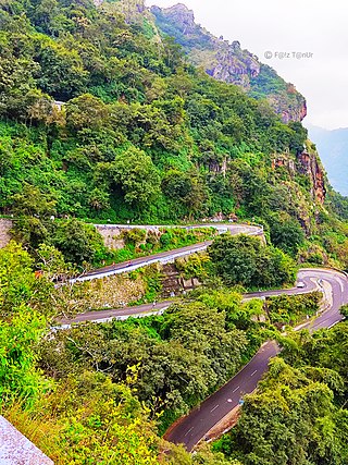
State Highway 78 or Valparai-Pollachi Road is a State Highway in Tamil Nadu, India that starts from Valparai and ends at the Pollachi. The 64-kilometre (40 mi) highway is often described by many as one of the best scenic routes in South India. There are 42 hairpin bends on this road. Monkey waterfalls and Aliyar waterfalls are located on this route. It connects with Valparai-Chalakudy road, another scenic route in South India.


