
The Golden Quadrilateral is a national highway network connecting several major industrial, agricultural and cultural centres of India. It forms a quadrilateral with all the four major metro cities of India forming the vertices, viz., Delhi (north), Kolkata (east), Mumbai (west) and Chennai (south). Other major cities connected by this network include Ahmedabad, Bengaluru, Balasore, Bhadrak, Bhubaneswar, Cuttack, Berhampur, Durgapur, Faridabad, Guntur, Gurugram, Jaipur, Kanpur, Pune, Kolhapur, Surat, Vijayawada, Eluru, Ajmer, Visakhapatnam, Bodhgaya, Varanasi, Prayagraj, Agra, Mathura, Dhanbad, Gandhinagar, Udaipur, and Vadodara. The main objective of these super highways is to reduce the travel time between the major cities of India, running roughly along the perimeter of the country. The North–South corridor linking Srinagar and Kanyakumari, and East–West corridor linking Silchar (Assam) and Porbandar (Gujarat) are additional projects. These highway projects are implemented by the National Highway Authority Of India (NHAI). At 5,846 kilometres (3,633 mi), it is the largest highway project in India and the fifth longest in the world. It is the first phase of the National Highways Development Project (NHDP), and consists of two, four, and six-lane express highways, built at a cost of ₹600 billion (US$7.2 billion). The project was planned in 1999, launched in 2001, and was completed in 7 January 2012.

The national highways in India are a network of limited access roads owned by the Ministry of Road Transport and Highways. National highways have flyover access or some controlled-access, where entrance and exit is through the side of the flyover. At each highway intersection, flyovers are provided to bypass the traffic on the city, town, or village. These highways are designed for speeds of 100 km/h. Some national highways have interchanges in between, but do not have total controlled-access throughout the highways. The highways are constructed and managed by the Central Public Works Department (CPWD), the National Highways and Infrastructure Development Corporation Limited (NHIDCL), and the public works departments (PWD) of state governments. Currently, the longest national highway in India is National Highway 44 at 4,112 km. India started four laning of major national highways with the National Highway Development Project (NHDP). As of March 2022 India has approximately 35,000 km of four laned National highways.

Reliance Infrastructure Limited (R-Infra), formerly Reliance Energy Limited (REL) and Bombay Suburban Electric Supply (BSES), is an Indian private sector enterprise involved in power generation, infrastructure, construction and defence. It is part of the Reliance Group. The company is headed by its chairman, Anil Ambani, and chief executive officer, Punit Narendra Garg. The corporate headquarters is in Navi Mumbai. Reliance Infrastructure's interests are in the fields of power plants, metro rail, airports, bridges, toll roads, and defence. It is a major shareholder in the other group company, Reliance Power and Reliance Naval and Engineering Limited.
The National Highways Authority of India or NHAI is an autonomous agency of the Government of India, set up in 1995 and is responsible for management of a road network of over 50,000 km of National highways out of 1,32,499 km in India. It is a nodal agency of the Ministry of Road Transport and Highways (MoRTH). NHAI has signed a memorandum of understanding (MoU) with the Indian Space Research Organisation (ISRO) for satellite mapping of highways.

Roads in India are an important mode of transport in India. India has a network of over 6,331,791 kilometres (3,934,393 mi) of roads. It is the second-largest road network in the world, after the United States. At of roads per square kilometre of land, the quantitative density of India's road network is equal to that of Hong Kong, and substantially higher than the United States, China, Brazil and Russia. Adjusted for its large population, India has approximately 5.13 kilometres (3.19 mi) of roads per 1,000 people, which is much lower than United States 20.5 kilometres (12.7 mi) but higher than that of China 3.6 kilometres (2.2 mi). India's road network carries over 71% of its freight and about 85% of passenger traffic.

The North–South–East–West r (NS-EW) is the largest ongoing highway project in India. It is the second phase of the National Highways Development Project (NHDP), and consists of building 7300 kilometers of four/six lane highways associating Srinagar, Kanyakumari, Kochi, Porbandar and Silchar, at a cost of US$12.317 billion ₹1000000000000(One lakh Crore INR). As of 19 March 2024, 6875 of the 7142 kilometers project has been finished.

The National Highways Development Project (NHDP) was a project of four laning of existing national highways and six laning of selected major national highways of India. The project was started in 1998 under the leadership of Prime Minister, Atal Bihari Vajpayee. National Highways account for only about 2% of the total length of roads, but carry about 40% of the total traffic across the length and breadth of the country. This project is managed by the National Highways Authority of India (NHAI) under the Ministry of Road, Transport and Highways. The NHDP represents 49,260 km of roads and highways work and construction in order to boost economic development of the country. The government has planned to end the NHDP program in early 2018 and subsume the ongoing projects under a larger Bharatmala project.

Kerala, a state in Southern India, has a network of 11 National Highways, 72 State Highways and many district roads.
National Highway 44 is a major north–south National Highway in India and is the longest in the country.
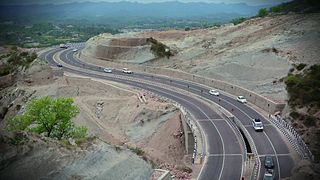
Expressways are the highest class of roads in India. In July 2023, the total length of expressways in India was 5,930 km (3,680 mi), with 11,127.69 km (6,914.43 mi) under construction. These are controlled-access highways where entrance and exits are controlled by the use of cloverleaf, three-way, trumpet or grade separated interchanges that are incorporated into the design of the expressway and designed for maximum speed of 120 km/h, whereas National highways are flyover access or tolled, where entrance and exit is through the side of the flyover, at each intersection of highway with road, flyovers are provided to bypass the city/town/village traffic and these highways are designed for speed of 100 km/h. Some roads are not access-controlled expressways but are still named expressways, such as the Bagodara–Tarapur Expressway, Biju Expressway, these are actually state highways that are not declared by the central government as an Expressway, hence not an Expressway or National Highway.
IRB Infrastructure Developers Limited, is an Indian highway construction company headed by Mr. Virendra Dattatraya Mhaiskar. It was incorporated in 1998, with its headquarters in Mumbai, Maharashtra, India. It is part of the IRB Group and was ranked 200th in the Fortune India 500 list in 2020. IRB Infrastructure, which executed the country's first build-operate-transfer (BOT) road project, is one of the largest operators of such ventures. Currently it has about 3,404 lane Km operational and about 2,330 lane Km under development. Among its notable projects are the Mumbai-Pune Expressway and the Ahmedabad-Vadodara Expressway. In 2012, IRB acquired Tamil Nadu based BOT road builder MVR Infrastructure and Tollways for ₹130 crore. The company got the contract of Ganga Expressway, the longest under-construction expressway in Uttar Pradesh.

BharatNet, also known as Bharat Broadband Network Limited (BBNL), is a central public sector undertaking, set up by the Department of Telecommunications, a department under the Ministry of Communications of the Government of India for the establishment, management, and operation of the National Optical Fibre Network to provide a minimum of 100 Mbit/s broadband connectivity to all 250,000-gram panchayats in the country, covering nearly 625,000 villages, by improving the middle layer of nation-wide broadband internet in India to achieve the goal of Digital India.

The Diamond Quadrilateral is a project of the Indian Railways to establish a high-speed rail network in India. The Diamond Quadrilateral will connect the four mega cities of India, viz. Delhi, Mumbai, Kolkata and Chennai, similar to the Golden Quadrilateral highway system.
Delhi–Meerut Expressway or National Expressway 3 is India's widest 96 km long controlled-access expressway, connecting Delhi with Meerut via Dasna in Ghaziabad in India. The 8 lanes old stretch of National Highway 9 (NH-9) up to Dasna is widened to 14 lanes. The fourth phase of the expressway is built on a new alignment from Dasna to Meerut – a six-lane stretch joining Meerut bypass. The 28 km (17 mi) stretch between Nizamuddin Bridge and Dasna is one of the most congested areas in the NCR. The total project cost is estimated to be between ₹8,000–10,000 crores.
The Sagarmala Programme is an initiative by the Government of India to enhance the performance of the country's logistics sector. The programme envisages unlocking the potential of waterways and the coastline to minimize infrastructural investments required to meet these targets.
The Indian Government is undertaking several initiatives to upgrade its aging railway infrastructure and enhance its quality of service. The Railway Ministry has announced plans to invest ₹5,400,000 crore to upgrade the railways by 2030. Upgrades include 100% electrification of railways, upgrading existing lines with more facilities and higher speeds, expansion of new lines, upgrading railway stations, introducing and eventually developing a large high-speed train network interconnecting major cities in different parts of India and development of various dedicated freight corridors to cut down cargo costs within the country.
The Bharatmala Pariyojna was a project in India implemented by Government of India. It was slated to interconnect 550 District Headquarters through a minimum 4-lane highway by raising the number of corridors to 50 and move 80% freight traffic to National Highways by interconnecting 24 logistics parks, 66 inter-corridors (IC) of total 8,000 km (5,000 mi), 116 feeder routes (FR) of total 7,500 km (4,700 mi) and 7 north east Multi-Modal waterway ports. The project also includez development of tunnels, bridges, elevated corridors, flyovers, overpass, interchanges, bypasses, ring roads etc. to provide shortest, jam free & optimized connectivity to multiple places, it is a centrally-sponsored and funded Road and Highways project of the Government of India. This ambitious umbrella programme subsumed all existing Highway Projects including the flagship National Highways Development Project (NHDP), launched by the Atal Bihari Vajpayee government in 1998. The total investment for 83,677 km (51,994 mi) committed new highways is estimated at ₹10.63 trillion (US$130 billion), making it the single largest outlay for a government road construction scheme. The project will build highways from Maharashtra, Gujarat, Rajasthan, Punjab, Haryana and then cover the entire string of Himalayan territories - Jammu and Kashmir, Himachal Pradesh, Uttarakhand - and then portions of borders of Uttar Pradesh and Bihar alongside Terai, and move to West Bengal, Sikkim, Assam, Arunachal Pradesh, and right up to the Indo-Myanmar border in Manipur and Mizoram. Special emphasis will be given on providing connectivity to far-flung border and rural areas including the tribal and backward areas.
Setu Bharatam was launched by Prime Minister Narendra Modi on 4 March 2016 at a budget of ₹102 billion (US$1.2 billion), with an aim to make all national highways free of railway crossings by 2019.
Surat–Chennai Expressway is an under-construction, 1,271 km (790 mi) long, 4/6-lane access-controlled expressway, which will connect the second largest city of Gujarat, Surat, with the capital of Tamil Nadu, Chennai, in India. It will pass through six states: Gujarat, Maharashtra, Karnataka, Telangana, Andhra Pradesh and Tamil Nadu. It will be operated and maintained by the National Highways Authority of India (NHAI), and will reduce both travel time and distance from around 35 hours to around 16 hours, and from approximately 1,570 km (980 mi) to 1,271 km (790 mi). It is being built at a cost of ₹ 45,000 crore (~US$5.5 billion), which was earlier slated at ₹ 50,000 crore. It will be the second longest expressway in India, after the Delhi–Mumbai Expressway.


