| National Highway 149 | ||||
|---|---|---|---|---|
| Major junctions | ||||
| From | Pallahara | |||
| To | Banarpal Square | |||
| Location | ||||
| Country | India | |||
| States | Odisha | |||
| Highway system | ||||
| ||||
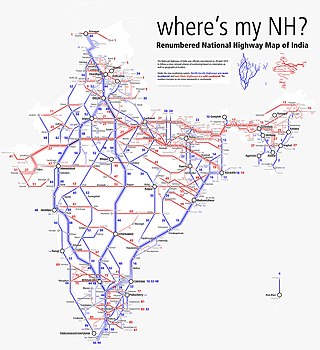
National Highway 149 is a national highway of India. [1]
| National Highway 149 | ||||
|---|---|---|---|---|
| Major junctions | ||||
| From | Pallahara | |||
| To | Banarpal Square | |||
| Location | ||||
| Country | India | |||
| States | Odisha | |||
| Highway system | ||||
| ||||
National Highway 149 is a national highway of India. [1]
Pallahara - Samal Barrage - Godibandha - Talcher - Nuahata was the old alignment of NH 149. But from 2024, NH 149 alignment was changed to Nauhatta - Talcher - Godibandha - Bajrakote - Rengali - Deogarh. The old alignment of Pallahara - Samal Barrage - Godibandha - Talcher is new labeled as NH 53. This has ensured trucks & vehicles reaching the 6 lane wide NH49 very quickly. The old route of NH53 via Rengali-Deogarh used to take a long time as it had multiple ghat sections.

New Hampshire Route 16 is a 154.771-mile (249.080 km), north–south state highway in New Hampshire, United States, the main road connecting the Seacoast region to the Lakes Region and the White Mountains. Much of its length is close to the border with Maine. The section from Portsmouth to Milton is a controlled-access toll highway known as the Spaulding Turnpike. Between Milton and Chocorua, and between Conway and Glen, it is known as the White Mountain Highway. It is known as Chocorua Mountain Highway between Chocorua and Conway and various other local names before crossing into Maine about 20 miles (32 km) south of the Canadian border. Portions of NH 16 run concurrent with U.S. Route 4 (US 4), US 202, NH 25, and US 302, and US 2.

The Brahmani is a major seasonal river in the Odisha state of eastern India. The Brahmani is formed by the confluence of the Sankh and South Koel rivers, and flows through the districts of Sundargarh, Deogarh, Angul, Dhenkanal, Cuttack, Jajapur and Kendrapara. Also South Koel can be considered as upper reaches of Brahmani. Together with the river Baitarani, Brahmani forms a large delta before emptying into the Bay of Bengal at Dhamra. It is the second widest river in Odisha after Mahanadi.

Angul district; also known as Anugul, is one of the thirty districts of Odisha in eastern India. The city of Angul is the district headquarters of Angul district. A major industrial hub of the state, the district hosts numerous industries relating to coal, bauxite and steel apart from extensive forests including the Satkosia Tiger Reserve.
National Highway 6 & Economic Corridor 1 (EC1), was a National Highway in India that has been separately designated under the new national highway numbering system. It was officially listed as running over 1,949 km (1,211 mi) from Surat to Kolkata. The route was also known as Asian Highway 46 (AH46) & Mumbai - Kolkata Highway and Great Eastern Highway.

Old National Highway 2 or Old NH 2, was a major National Highway in India, that connected the states of Delhi, Haryana, Uttar Pradesh, Bihar, Jharkhand and West Bengal. It constitutes a major portion of the historical Grand Trunk Road along with old NH 91 and old NH 1 in India. The highway connects national capital Delhi with Kolkata as well as important cities such as Faridabad, Mathura, Agra, Kanpur, Allahabad, Varanasi, Dhanbad, Asansol, Durgapur and Bardhaman.

Sambalpur Lok Sabha constituency is one of the 21 Lok Sabha (parliamentary) constituencies in Odisha state in eastern India. This constituency covers the whole Sambalpur district and parts of Deogarh and Angul districts.
Deogarh Lok Sabha constituency was a Lok Sabha (parliamentary) constituency in Orissa state in eastern India till 2008. Assembly constituencies which constituted this parliamentary constituency were: Pallahara, Talcher, Brajarajnagar, Jharsuguda, Laikera, Kuchinda and Deogarh. After 2008, some of the constituencies went into Bargarh and some into Dhenkanal.
Bonaigarh, also locally known as Bonai, is a subdivision of Sundergarh district of the Indian state of Odisha. It is 162 km east of the district headquarters in Sundargarh. It is a sub-divisional headquarter. The town is surrounded by the River Brahmani and the Khandadhar and Singardei Hills. Notable places of interest include a temple to the Lord Shiva and a Royal Palace.

Pallahara is a Vidhan Sabha constituency of Angul district, Odisha.

The Kanhan River is an important right bank tributary of the Wainganga River draining a large area lying south of Satpura range in central India. Along its 275 km run through the Indian States of Maharashtra and Madhya Pradesh, it receives its largest tributary - Pench River, a major water source for the metropolis of Nagpur.
The Odisha Construction Corporation or OCC is a premier Government of Odisha undertaking. Established in the year 1962 under the then Indian National Congress government of Biju Patnaik(fourth Chief Minister of Odisha) to undertake specialised civil and mechanical construction works hence creating an infrastructure base in the state of Odisha. The Odisha Construction Corporation is headed by the principal secretary to government, water resources as ex-officio chairman.

National Highway 14 is a National Highway in India. It runs from Morgram to Kharagpur in the Indian state of West Bengal.

National Highway 55 is a National Highway in India connecting Sambalpur and Cuttack in Indian state of Odisha. Starting from NH 53 in Maneswar, Sambalpur, it terminates at NH 16, in Manguli Square, Cuttack. it is also known as Cuttack - Sambalpur Highway. Before renumbering of national highways of India, route of NH-55 was part of old national highway 42. This national highway is 263 km (163 mi) long.

National Highway 53, combination of old, & is a national highway in India. It connects Hajira in Gujarat and Paradeep port in Odisha. NH-53 traverses the states of Gujarat, Maharashtra, Chhattisgarh and Odisha in India. The road is the part of AH46 network in India and it is officially listed as running over 1975 km (1227 mi) from Kolkata to Surat. it is also known as Surat - Kolkata Highway. It passes through Maharashtra, Chhattisgarh and Odisha states.
National Highway 49 is a primary National Highway in India. This highway runs from Bilaspur in the Indian state of Chhattisgarh to Kharagpur in West Bengal. Starting from NH 130 near Bilaspur, it terminates at NH 16 near Kharagpur, West Bengal. The highway is part of AH46 network in India. This national highway is 668 km (415 mi) long.
National Highway 58 is a National Highway in India connecting Fatehpur and Udaipur in the state of Rajasthan. NH58 route is extended from Udaipur to Palanpur in Gujarat.
National Highway 919 is a National Highway in India. It connects Palwal and Rewari in Haryana via Dharuhera and Sohna, all of which are in Haryana.
Kulei is a traditional Indian village belongs to Angul district of Odisha. Kulei is the 6th most populous village in Samal Barrage sub district of Angul district. The area of the village is 3 km2, making it the 17th largest village in the subdistrict. The population density of Kulei is 516 people per km2. 0.54 km2, (19%) of which is covered with forest.
National Highway 352W commonly referred to as Gurgaon-Pataudi Road is a national highway in India. It is a spur road of National Highway 352 from Narwana to Rewari, which itself is a spur road of National Highway 52. NH 352W traverses only one state, the state of Haryana in India.
National Highway 751, commonly referred to as NH 751 is a national highway in India. It is a secondary route of National Highway 51. NH-751 runs in the state of Gujarat in India.