
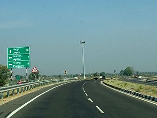
The National highways in India are a network of trunk roads owned by the Ministry of Road Transport and Highways. National highways have flyover access or some controlled-access, where entrance and exit is through the side of the flyover, at each intersection of highways flyovers are provided to bypass the city/town/village traffic and these highways are designed for speed of 100 km/h. Some national highways have interchanges in between, but do not have total controlled-access throughout the highways. It is constructed and managed by the Central Public Works Department (CPWD), the National Highways and Infrastructure Development Corporation Limited (NHIDCL), and the public works departments (PWD) of state governments. Currently, the longest National Highway in India is National Highway 44 at 4,112 km. India started four laning of major national highways with National Highway Development Project (NHDP). As of March 2022 India have approximately 35,000 km of four laned National highways.

Gangtok is a city, municipality, the capital and the most populous city of the Indian state of Sikkim and also the headquarters of Gangtok District. Gangtok is in the eastern Himalayan range, at an elevation of 1,650 m (5,410 ft). The city's population of 100,000 consists of the three Sikkimese ethnicities the Bhutias, Lepchas, Gorkhalis and also plainsmen from other states of India have settled here. Within the higher peaks of the Himalayas and with a year-round mild temperate climate, Gangtok is at the centre of Sikkim's tourism industry.

Gangtok District is an administrative district of the Indian state of Sikkim. It was renamed in 2021 as a result of administrative reorganisation of the state, which also saw three subdivisions of the East Sikkim district spawned off as a separate Pakyong district.

The Border Roads Organisation (BRO) is a statutory body under the ownership of the Ministry of Defence of the Government of India. BRO develops and maintains road networks in India's border areas and friendly neighboring countries. This includes infrastructure operations in 19 states and three union territories and neighboring countries such as Afghanistan, Bhutan, Myanmar, Tajikistan and Sri Lanka. By 2022, BRO had constructed over 55,000 kilometres (34,000 mi) of roads, over 450 permanent bridges with a total length of over 44,000 metres (27 mi) length and 19 airfields in strategic locations. BRO is also tasked with maintaining this infrastructure including operations such as snow clearance.

A controlled-access highway is a type of highway that has been designed for high-speed vehicular traffic, with all traffic flow—ingress and egress—regulated. Common English terms are freeway, motorway and expressway. Other similar terms include throughway and parkway. Some of these may be limited-access highways, although this term can also refer to a class of highways with somewhat less isolation from other traffic.

Roads in India are an important mode of transport in India. India has a network of over 6,331,791 kilometres (3,934,393 mi) of roads. This is the second-largest road network in the world, after the United States. At of roads per square kilometre of land, the quantitative density of India's road network is equal to that of Hong Kong, and substantially higher than the United States, China, Brazil and Russia. Adjusted for its large population, India has approximately 5.13 kilometres (3.19 mi) of roads per 1,000 people, which is much lower than United States 20.5 kilometres (12.7 mi) but higher than that of China 3.6 kilometres (2.2 mi). India's road network carries over 71% of its freight and about 85% of passenger traffic.

The National Highways Development Project (NHDP) was a project of four laning of existing national highways and six laning of selected major national highways of India. The project was started in 1998 under the leadership of Prime Minister, Atal Bihari Vajpayee. National Highways account for only about 2% of the total length of roads, but carry about 40% of the total traffic across the length and breadth of the country. This project is managed by the National Highways Authority of India (NHAI) under the Ministry of Road, Transport and Highways. The NHDP represents 49,260 km of roads and highways work and construction in order to boost economic development of the country. The government has planned to end the NHDP program in early 2018 and subsume the ongoing projects under a larger Bharatmala project.
Himachal Pradesh, although railways and airways serve very limited transport needs, the road network of the state serves the transport needs of the people. Although, the geography of Himachal presents considerable challenge to the development of transport infrastructure, it has the highest road density among all the Hill States of India. Himachal also has 3 airports, 2 narrow gauge rail tracks and couple of other under-construction broad gauge railway tracks, but roads remain the main mode of transport.
The Ministry of Development of North Eastern Region is a Government of India ministry, established in September 2001, which functions as the nodal Department of the Central Government to deal with matters related to the socio-economic development of the eight States of Northeast India: Arunachal Pradesh, Assam, Manipur, Meghalaya, Mizoram, Nagaland, Tripura and Sikkim. It acts as a facilitator between the Central Ministries/ Departments and the State Governments of the North Eastern Region in the economic development including removal of infrastructural bottlenecks, provision of basic minimum services, creating an environment for private investment and to remove impediments to lasting peace and security in the North Eastern Region.

Kerala, a state in Southern India, has a network of 11 National Highways, 72 State Highways and many district roads.
Expressways are the highest class of roads in India. As of July 2023, India has a total length of 5,145 km (3,197 mi) of expressways. These are controlled-access highways where entrance and exits are controlled by the use of cloverleaf or trumpet or grade separated interchanges that are incorporated into the design of the expressway and designed for maximum speed of 120 km/h, whereas National highways are flyover access or tolled, where entrance and exit is through the side of the flyover, at each intersection of highway with road, flyovers are provided to bypass the city/town/village traffic and these highways are designed for speed of 100 km/h. Some roads are not access-controlled expressways but are still named expressways, such as the Biju Expressway, these are actually state highways that are not declared by the central government as an Expressway, hence not an Expressway or National Highway.
In India, this is the network of roads maintained by the state governments. These roads are constructed and managed by the states' Public Works Department. The state highways are usually roads that link important cities, towns and district headquarters within the state and connect them with National Highways or state highways of neighbouring states.
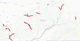
Arunachal Frontier Highway (AFH), officially notified as the National Highway NH-913 and also called Bomdila-Vijaynagar Highway (BVH), connecting Bomdila Airstrip ALG & HQ in northwest to Vijaynagar Airstrip ALG & HQ in southeast via Nafra HQ-Sarli HQ-Huri Helipad ALG & HQ-Nacho HQ-Mechuka Airstrip ALG & HQ-Monigong HQ-Jido -Hunli HQ-Hayuliang Airstrip ALG HQ-Chenquenty-Hawai HQ-Miao HQ including 800 km greenfield section and network of new tunnels & bridges, is a 2-lane paved-shoulder under-construction national highway along the India-China LAC-McMahon Line border in the Indian state of Arunachal Pradesh. The 1,748 km-long (1,086 mi) highway itself will cost ₹27,000 crore and total cost including 6 additional inter-corridors is ₹40,000 crore. In some places, this highway will run as close as 20 km from the LAC. To be constructed by MoRTH in 9 packages, all packages will be approved by the end of fy 2024-25 and construction will be completed in 2 years by 31 March 2027. Of the total route, 800km is greenfield, rest brownfield will be upgraded and tunnels will be built. This highway in the north & east Arunachal along the China border, would complement the Trans-Arunachal Highway and the Arunachal East-West Corridor as major highways spanning the whole state, pursuing the Look East connectivity policy.
National Highway 10 is a national highway in North East India that connects Indo/Bangladesh border via Siliguri to Gangtok. It passes through the Indian states of West Bengal and Sikkim.The highway is being maintained by the National Highways and Infrastructure Development Corporation Limited (NHIDCL) from Rangpo to Ranipool in the state of Sikkim.
The Bharatmala Pariyojna is an ongoing project that will interconnect 550 District Headquarters through a minimum 4-lane highway by raising the number of corridors to 50 and move 80% freight traffic to National Highways by interconnecting 24 logistics parks, 66 inter-corridors (IC) of total 8,000 km (5,000 mi), 116 feeder routes (FR) of total 7,500 km (4,700 mi) and 7 north east Multi-Modal waterway ports. The project also includes development of tunnels, bridges, elevated corridors, flyovers, overpass, interchanges, bypasses, ring roads etc. to provide shortest, jam free & optimized connectivity to multiple places, it is a centrally-sponsored and funded Road and Highways project of the Government of India. This ambitious umbrella programme will subsume all existing Highway Projects including the flagship National Highways Development Project (NHDP), launched by the Atal Bihari Vajpayee government in 1998. Bharatmala is mainly focused on connecting remote areas and satellite cities of megacities such as Bengaluru, Pune, Hyderabad etc. The total investment for 83,677 km (51,994 mi) committed new highways is estimated at ₹10.63 lakh crore (US$130 billion), making it the single largest outlay for a government road construction scheme. The project will build highways from Maharashtra, Gujarat, Rajasthan, Punjab, Haryana and then cover the entire string of Himalayan territories - Jammu and Kashmir, Himachal Pradesh, Uttarakhand - and then portions of borders of Uttar Pradesh and Bihar alongside Terai, and move to West Bengal, Sikkim, Assam, Arunachal Pradesh, and right up to the Indo-Myanmar border in Manipur and Mizoram. Special emphasis will be given on providing connectivity to far-flung border and rural areas including the tribal and backward areas.
India–China Border Roads is a Government of India project for developing infrastructure along the Sino-Indian border by constructing strategic roads, including bridges and tunnels. The ICBR project is largely in response to Chinese infrastructure development along the borderlands with India.


