Ladakh is a region administered by India as a union territory and constitutes an eastern portion of the larger Kashmir region that has been the subject of a dispute between India and Pakistan since 1947 and India and China since 1959. Ladakh is bordered by the Tibet Autonomous Region to the east, the Indian state of Himachal Pradesh to the south, both the Indian-administered union territory of Jammu and Kashmir and the Pakistan-administered Gilgit-Baltistan to the west, and the southwest corner of Xinjiang across the Karakoram Pass in the far north. It extends from the Siachen Glacier in the Karakoram range to the north to the main Great Himalayas to the south. The eastern end, consisting of the uninhabited Aksai Chin plains, is claimed by the Indian Government as part of Ladakh, but has been under Chinese control.

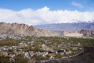
Leh is a city in Indian-administered Ladakh in the disputed Kashmir region. It is the largest city and the joint capital of Ladakh. Leh, located in the Leh district, was also the historical capital of the Kingdom of Ladakh. The seat of the kingdom, Leh Palace, the former residence of the royal family of Ladakh, was built in the same style and about the same time as the Potala Palace in Tibet. Since they were both constructed in a similar style and at roughly the same time, the Potala Palace in Tibet and Leh Palace, the royal residence, are frequently contrasted. Leh is at an altitude of 3,524 m (11,562 ft), and is connected via National Highway 1 to Srinagar in the southwest and to Manali in the south via the Leh-Manali Highway.

Kargil district is a district in Indian-administered Ladakh in the disputed Kashmir-region, which is administered as a union territory of Ladakh. It is named after the city of Kargil, where the district headquarters lies. The district is bounded by the Indian-administered union territory of Jammu and Kashmir to the west, the Pakistani-administered administrative territory of Gilgit–Baltistan to the north, Ladakh's Leh district to the east, and the Indian state of Himachal Pradesh to the south. Encompassing three historical regions known as Purig, Dras and Zanskar, the district lies to the northeast of the Great Himalayas and encompasses the majority of the Zanskar Range. Its population inhabits the river valleys of the Dras, Suru, Wakha Rong, and Zanskar.
Leh district is a district in Indian-administered Ladakh in the disputed Kashmir-region. Ladakh is an Indian-administered union territory. With an area of 45,110 km2, it is the second largest district in the country, second only to Kutch. It is bounded on the north by Gilgit-Baltistan's Kharmang and Ghanche districts and Xinjiang's Kashgar Prefecture and Hotan Prefecture, to which it connects via the historic Karakoram Pass. Aksai Chin and Tibet are to the east, Kargil district to the west, and Lahul and Spiti to the south. The district headquarters is in Leh. It lies between 32 and 36 degree north latitude and 75 to 80 degree east longitude.

Kargil or Kargyil is a city in Indian-administered Ladakh in the Kashmir region. It is the joint capital of Ladakh, an Indian-administered union territory. It is also the headquarters of the Kargil district. It is the second-largest city in Ladakh after Leh. Kargil is located 204 kilometres (127 mi) east of Srinagar in Jammu and Kashmir, and 234 kilometres (145 mi) to the west of Leh. It is on the bank of the Suru River near its confluence with the Wakha Rong river, the latter providing the most accessible route to Leh.

Ladakh has a long history with evidence of human settlement from as back as 9000 b.c. It has been a crossroad of high Asia for thousands of years and has seen many cultures, empires and technologies born in its neighbours. As a result of these developments Ladakh has imported many traditions and culture from its neighbours and combining them all gave rise to a unique tradition and culture of its own.

The Dras River, also spelt Drass River, is a river in the Kargil district in the Indian union territory of Ladakh. It originates below the Zoji La pas in the Great Himalayan range and flows northeast towards Kargil, where it joins the Suru River. The Shingo River, which flows in a parallel direction in Pakistan-administered Baltistan, also joins the Dras River. The combined river is alternatively called Suru, Drass and Shingo by various local groups.
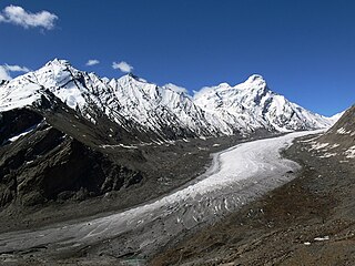
The Drang-Drung Glacier is a mountain glacier near the Pensi La pass on the Kargil-Zanskar Road in the Kargil district of Ladakh in India.

Tourism is one of the economic contributors to the union territory of Ladakh in Northern India. This union territory is located between the Karakoram mountain range to the north and the Himalayas to the south, and is situated at a height of 11,400 ft. Ladakh is composed of Leh and Kargil districts. The region contains prominent Buddhist sites and has an ecotourism industry.

Dras, also known locally in Shina as Himababs, Hembabs, or Humas, is a town and hill station, and the headquarters of Drass district of the union territory of Ladakh in India. It is on the NH 1 between Zoji La pass and Kargil. A tourist hub for its high-altitude trekking routes and tourist sites, it is often called "The Gateway to Ladakh". The government's official spelling of the town's name is "Drass".

Sonamarg or Sonmarg, known as Sonamarag in Kashmiri, is a hill station located in the Ganderbal District of Jammu and Kashmir, India. It is located about 62 kilometers from Ganderbal Town and 80 kilometres (50 mi) northeast of the capital city, Srinagar.

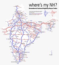
National Highway 1D, also known as Srinagar–Leh Highway, was a National Highway in the state of Jammu and Kashmir that connected Srinagar to Leh in Ladakh. The Srinagar-Leh Highway was declared as National Highway in 2006. It is now part of National Highway 1 that extends west to Uri.
Military operations took place in Ladakh in 1948 during the conflict in Jammu and Kashmir between the Indian Army and Pakistani raiders infiltrated to capture the kingdom of Jammu and Kashmir. The eviction of this invading force of tribal raiders, who enjoyed numerical superiority, better lines of communication, commanding high ground and superior logistics, was a major military achievement for the small force of Indian soldiers.

Zoji La is a high mountain pass in the Himalayas. It is in the Kargil district, Indian Union territory of Ladakh. Located in the Dras subdivision, the pass connects the Kashmir Valley to its west with the Dras and Suru valleys to its northeast and the Indus valley further east. National Highway #1 between Srinagar and Leh in the western section of the Himalayan mountain range, traverses the pass. As of late 2022, an all-weather Zoji-la Tunnel is under construction to mitigate seasonal road blockages due to heavy snowfall.

National Highway 3, or NH 3, is a national highway in India. It starts from Atari adjacent to India-Pakistan border and near Amritsar and terminates at Leh in Ladakh, via Manali in Himachal Pradesh.

The Z-MorhTunnel is a 6.5 km long 2-lane road tunnel between Gagangair and Sonamarg in Ganderbal district of Union Territory of Jammu and Kashmir in India. It is named after the Z-shaped stretch of road that the tunnel has replaced. The road used before was avalanche-prone and used to get blocked for several months, but the Z-Morh tunnel provides all-weather connectivity to the Sonamarg tourist town. It takes only 15 minutes to travel the 6.5 km long tunnel compared to hours over the zig-zag road up and down the hills.
Zoji La Tunnel is an under-construction 9.5 m wide, 7.57 m high and 14.2 km long, horseshoe-shaped single-tube, 2 lane road tunnel at the height of 11,575 feet above sea level which passes under the Zoji La pass in the Himalayas between Ganderbal of Kashmir (J&K) and Drass town in Kargil district of Ladakh. The project cost for this smart tunnel (SCADA) system, constructed using the New Austrian tunneling method and equipped with CCTV, radio control, uninterrupted power supply, ventilation, etc is INR 8,308 crore as per 2021 estimates. Together with the adjacent Z-Morh Tunnel, this geostrategically important tunnel on the NH1 Srinagar-Leh Highway will provide year around weather-proof connectivity to Ladakh and Baltal, reduce the earlier 1-1.5 hours travel time to just 15 minutes drive, boost the tourism and economy, and enhance the logistics of the Indian Armed Forces. It is one of the 31 road tunnels being constructed at a combined cost of INR1400 billion.
Hardas is a village in Kargil district of the Indian union territory of Ladakh, close to the India–Pakistan border (LOC). The village is located 10 kilometres north of Kargil, the district headquarters, on the left of the Dras River.

Nimmu–Padum–Darcha road or Zanskar Highway is a road between the Indian union territory of Ladakh and the state of Himachal Pradesh, passing through the region of Zanskar. It connects Nimmu in the Indus Valley to Padum, the capital of Zanskar, and to Darcha village in Lahul and Spiti. It provides an alternative to the Leh–Manali Highway in linking Ladakh with the rest of India. It was built by the Border Roads Organisation (BRO) of the Indian Army. The construction of road was completed in March 2024. The already completed Atal tunnel, and the proposed unidirectional-twin-tube total-4-lane Shingo La Tunnel, which is expected to be completed by 2027 will provide all weather connectivity and reduce the distance from Manali to Kargil by 522 km.
Meenamarg is one the entry points in Ladakh from Jammu and Kashmir in India. It is just east of Zoji La Pass. Meenamarg lies on the National Highway 1 between Srinagar and Leh. A full-fledged COVID-19 screening post was established in Meenamarg in 2020.