Muzaffarnagar is a city under Muzaffarnagar district in the Indian State of Uttar Pradesh. It is situated midway on the Delhi - Haridwar/Dehradun National Highway and is also well connected with the national railway network. It is known as the sugarbowl of Uttar Pradesh.
Saharanpur is a city and a municipal corporation in Uttar Pradesh, India. It is also the administrative headquarters of Saharanpur district.

The National Capital Region is a planning region centred upon the National Capital Territory (NCT) of Delhi in India. It encompasses Delhi and several districts surrounding it from the states of Haryana, Uttar Pradesh, and Rajasthan. The NCR and the associated National Capital Region Planning Board (NCRPB) were created in 1985 to plan the development of the region and to evolve harmonized policies for the control of land-uses and development of infrastructure in the region. Prominent cities of NCR include Delhi, Faridabad, Ghaziabad, Gurgaon and Noida.
Thana Bhawan is a town in Shamli district in the Indian state of Uttar Pradesh. It was known as Prabuddhnagar first time, when this district came into focus. It is situated on Delhi–Shamli national highway, it is 100 km away from Delhi, 45 km from Saharanpur, 38 km from Muzaffarnagar and 59.6 km away from Panipat (Haryana). Border of this district is connected with district Muzaffarnagar in east and with Haryana in west and with Saharanpur in north and with district Baghpat it is connected in south. It is said that the name Thana Bhawan emerged from the name of Devi Bhawan Temple. In the 18th century it was home to mostly Hindu and Muslims families. It is situated on the Delhi–Saharanpur highway NH 709B around 120 kilometres (75 mi) from Delhi.

Ailum, is Nagar panchayat town in Shamli district in the Indian state of Uttar Pradesh, situated in the upper doab region of River Ganga and Yamuna. It is located at a distance of 75 km from National Capital New Delhi and a part of the National Capital Region (NCR) of India.
Noorpur is a City and a Municipal Board in Bijnor District in the Indian State of Uttar Pradesh.
National Highway 44 is a major north–south National Highway in India and is the longest in the country.

Western Uttar Pradesh is a region in India that comprises the western districts of Uttar Pradesh state, including the areas of Rohilkhand and those where Hindi, Urdu and Braj are spoken; it is in the region of Western Uttar Pradesh that Hindi-Urdu originated. The region has some demographic, economic and cultural patterns that are distinct from other parts of Uttar Pradesh, and more closely resemble those of Haryana and Rajasthan states. The largest city of the region is Ghaziabad, while the second-largest city, Agra, is a major tourist destination.

The Uttar Pradesh Expressways Industrial Development Authority (UPEIDA) is an authority set up in 2007 by the Government of Uttar Pradesh to develop expressway projects in the state. The headquarters of UPEIDA is located at Paryatan Bhawan in Gomti Nagar, Lucknow.

Shamli is a district in the Indian state of Uttar Pradesh. This district was carved out from Muzaffarnagar District on 28 September 2011 as Prabudh Nagar and renamed Shamli in July 2012. Shamli is the headquarters of the district. Shamli is located along the Delhi-Saharanpur-Dehradun Expressway, Ambala-Shamli Expressway, Gorakhpur-Shamli Expressway, Delhi–Saharanpur, Meerut-Karnal and Panipat-Khatima Highways.
National Highway NH 34 is a National Highway in India. It runs from Gangotri Dham in Uttarakhand to Lakhnadon in Madhya Pradesh, passing through the state of Uttar Pradesh.
National Highway 344 is a national highway in India running from Ambala in Haryana to Roorkee in Uttarakhand. It is a secondary route of National Highway 44. NH-344 runs in the states of Haryana, Punjab, Uttar Pradesh and Uttarakhand in India.
Khandrawali is a large village located in Kairana tehsil of Shamli district in the Indian state of Uttar Pradesh.
National Highway 148B starts at Kotputli, state of Rajasthan and ends at Bathinda, state of Punjab. The major towns are in succession of distance on this highway: Narnaul, Mahendergarh, Charkhi Dadri, Bhiwani, Hansi, Barwala, Bhimewala Tohana, Moonak, Jakhal, Bareta, Budhlada, Bhikhi, Mansa and Maur. This highway meets with National Highway 54 at Bathinda. The highway is 427 km (265 mi) long and runs all within the states of Haryana, Punjab and Rajasthan.
National Highway 709A, commonly called NH 709A is a national highway in India. It is a greenfield spur road of NH-709. NH-709A traverses the states of Haryana and Uttar Pradesh in India. Karnal to Meerut section has been upgraded from 4 lanes to 6 lanes by Public Works Department, Haryana.
National Highway 334B, commonly called NH 334B is a national highway in India. It is a spur road of National Highway 34. NH-334B traverses the states of Uttar Pradesh and Haryana in India.
National Highway 709B, is a National Highway in India. The highway starts from Akshardham in Delhi. It is a spur road of National Highway 9. NH-709B traverses the states of Delhi and Uttar Pradesh passing through various towns and cities in Western Uttar Pradesh like Baghpat, Baraut, Ailum, Shamli, Thanabhawan, Rampur Maniharan, Saharanpur, Behat, Shakumbhari. Shamli acts as a major junction as two other major highways of the area (709A) and (709AD) intersect with (709B) at Shamli.
National Highway 334D, commonly referred to as NH 334D is a national highway in India. It is a secondary route of National Highway 34. NH-334D runs in the states of Uttar Pradesh and Haryana in India.
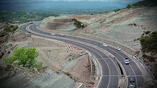
The Delhi–Saharanpur–Dehradun Expressway, also known as National Highway 709B (NH 709B), is an under-construction, 210 kilometres (130 mi) long, 12/6 lane access-controlled expressway, which will connect Delhi, the national capital of India, with Dehradun, the capital of the Indian state of Uttarakhand. It will pass through the states of Delhi, Uttar Pradesh and Uttarakhand, and will pass through the cities of Baghpat, Baraut, Shamli and Saharanpur. The National Highway 307 (NH-307) is also apart of Delhi Dehradun Expressway.