The Grand Trunk Road, formerly known as Sarak-e-Azam(سڑکِ اعظم), Badshahi Sarak(بادشاہی سڑک), and Sarak-e-Sher Shah(سڑکِ شیر شاہ), is one of Asia's oldest and longest major roads. For at least 2,500 years it has linked Central Asia to the Indian subcontinent. It runs roughly 2,400 km (1,491 mi) from Teknaf, Bangladesh on the border with Myanmar west to Kabul, Afghanistan, passing through Chittagong and Dhaka in Bangladesh, Kolkata, Prayagraj, Delhi, and Amritsar in India, and Lahore, Rawalpindi, and Peshawar in Pakistan.

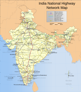
The Golden Quadrilateral is a national highway network connecting several major industrial, agricultural and cultural centres of India. It forms a quadrilateral with all the four major metro cities of India forming the vertices, viz., Delhi (north), Kolkata (east), Mumbai (west) and Chennai (south). Other major cities connected by this network include Ahmedabad, Bengaluru, Balasore, Bhubaneswar, Cuttack, Berhampur, Durgapur, Guntur, Jaipur, Kanpur, Pune, Kolhapur, Surat, Vijayawada, Ajmer, Vizag, Bodhgaya, Varanasi, Prayagraj, Agra, Mathura, Dhanbad, Gandhinagar, Udaipur, and Vadodara. The main objective of these super highways is to reduce the travel time between the major cities of India, running roughly along the perimeter of the country. The North–South corridor linking Srinagar and Kanyakumari, and East–West corridor linking Silchar (Assam) and Porbandar (Gujarat) are additional projects. These highway projects are implemented by the National Highway Authority Of India (NHAI). At 5,846 kilometres (3,633 mi), it is the largest highway project in India and the fifth longest in the world. It is the first phase of the National Highways Development Project (NHDP), and consists of four and six-lane express highways, built at a cost of ₹600 billion (US$7.5 billion). The project was planned in 1999, launched in 2001, and was completed in July of 2013.

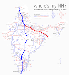
The National highways in India are a network of trunk roads owned by the Ministry of Road Transport and Highways. It is constructed and managed by the Central Public Works Department (CPWD), the National Highways and Infrastructure Development Corporation Limited (NHIDCL), and the public works departments (PWD) of state governments. Currently, the longest National Highway in India is National Highway 44 at 4,112 km.

State Route 156 is a primary state highway in the U.S. state of Virginia. The state highway runs 57.38 miles (92.34 km) from U.S. Route 301 and SR 35 in Templeton north to US 360 Business in Mechanicsville. SR 156 follows a circuitous route through the eastern part of the Richmond–Petersburg metropolitan area. South of the James River, the state highway connects Templeton in Prince George County with Hopewell, which is directly served by SR 156 Business. SR 156 crosses the James River on the Benjamin Harrison Memorial Bridge and briefly passes through Charles City County. For most of its length in Henrico and Hanover, the state highway is a rural road that provides access to several units of Richmond National Battlefield Park. However, SR 156 provides access to Richmond International Airport, Interstate 64 (I-64), and I-295 as it passes through the Richmond suburbs of Sandston and Highland Springs as a major highway.

Shirali is a village in Bhatkal taluk of Uttara Kannada district in Karnataka. Shirali is home to two prominent temples: the Chitrapur Math and the Maha Ganapathi Mahammaya Temple. The Chitrapur Math is the holiest temple of the Chitrapur Saraswat Brahmin community, and the Maha Ganapathi Mahammaya temple is the Kuladev to the Kamaths, Bhats, Puraniks, Prabhus, Joishys, Mallyas, Kudvas and Nayak families from the Goud Saraswat Brahmin community.

Garhwa District is one of the twenty-four districts in the Indian state of Jharkhand. The Garhwa District is part of the Palamu division and has its administrative headquarters in Garhwa City.
Roads are an important mode of transport in India. India has a network of over 6,215,797 kilometres (3,862,317 mi) of roads as of 1 December 2021. This is the second-largest road network in the world, after the United States with 6,853,024 kilometres (4,258,272 mi). At of roads per square kilometre of land, the quantitative density of India's road network is equal to that of Hong Kong, and substantially higher than the United States, China, Brazil and Russia. Adjusted for its large population, India has approximately 5.13 kilometres (3.19 mi) of roads per 1,000 people, which is much lower than United States 20.5 kilometres (12.7 mi) but higher than that of China 3.6 kilometres (2.2 mi). India's road network carries over 71 percent of its freight and about 85 percent of passenger traffic.

The North–South–East–West Corridor (NS-EW) is the largest ongoing highway project in India. It is the second phase of the National Highways Development Project (NHDP), and consists of building 7300 kilometers of four/six lane highways associating Srinagar, Kanyakumari, Kochi, Porbandar and Silchar, at a cost of US$12.317 billion. As of 31 March 2018, 6875 of the 7142 kilometers project has been finished.

Argari is a census town in Sankrail CD Block of Howrah Sadar subdivision in Howrah district in the Indian state of West Bengal. It is a part of Kolkata Urban Agglomeration.
Phalodi is a town and a municipality in Jodhpur district in the Indian state of Rajasthan. It is the headquarters for Phalodi tehsil. Phalodi is also called the "salt city" due to the salt industry in Rin. Phalodi is in the buffer zone of Thar Desert and often subject to extreme temperature conditions due to its arid climate. It holds the record for the highest verified temperature recorded in Rajasthan at 51 °C (124 °F) on 19 May 2016. It is also the highest temperature ever recorded in India.

The Leh–Manali Highway is a 428 km (266 mi) long highway in northernmost India connecting Leh, the capital of the union territory of Ladakh, to Manali in the state of Himachal Pradesh. It connects the Manali Solang valley to the Lahaul and Spiti valleys in Himachal Pradesh and the Zanskar valley in Ladakh. It is open for about six months in a year, from first week of May to October, when snowfall again blocks the high passes on the highway. However, the Lahaul valley now remains connected to Manali for most part of the year through already completed Atal tunnel. With the completion of proposed Shingo La Tunnel on new route through Zanskar valley, targeted to be completed by 2025, the whole Leh-Manali route will become all-weather road.

National Route 22 is a national highway connecting Nagoya, Aichi Prefecture, and Gifu, Gifu Prefecture in Japan. The route follows the old Minoji, a 17th-century trade route that connected the Nakasendō and the Tōkaidō.

National Route 156 is a national highway of Japan connecting Gifu and Takaoka, Toyama in Japan, with a total length of 213.3 km (132.5 mi).

Expressways are the highest class of roads in India. As of July 2022, India has a total length of 2,587.5 km (1,607.8 mi) of expressways. These are controlled-access highways where entrance and exits are controlled by the use of ramps that are incorporated into the design of the expressway, whereas National highways are at-grade roads. Some roads are not access-controlled expressways, but are still officially called expressways, such as the Biju Expressway and Raipur–Bilaspur Expressway these highways do not meet expressway standards. Mumbai–Pune Expressway is the first 6-lane operational expressway in India started in 2002. Expressways follows standards set by Indian Roads Congress and Bureau of Indian Standards.
National Highway 52, Sangrur, Punjab to Ankola, Karnataka, is a National Highway in India. The national highway 52 was numbered after amalgamating many existing national highways of India. The old highway numbered NH-63 was from Ankola in Karnataka state to Gooty in Andhra pradesh state. The highway 52 starts at the junction of National Highway 66 at Ankola and moves up to Arebail ghat of Western ghats and then to Yellapura and further to Hubballi (Hubli) city. Some stretch of old national highway 13 from Vijayapura to Solapur was joined with NH-52. Lorries coming Hubballi city to Karwar sea port and New Mangalore sea port (NMPT) use this highway.The road stretch from Ankola to Yellapura is through forests of Western ghats of India.
National Highway 66, commonly referred to as NH 66, is a 4 lane 1,608 km (999 mi) long busy National Highway that runs roughly north–south along the western coast of India, parallel to the Western Ghats. It connects Panvel to Cape Comorin (Kanyakumari), passing through the states of Maharashtra, Goa, Karnataka, Kerala and Tamil Nadu.

National Highway 19 is a national highway in India. It was previously referred to as Delhi–Kolkata Road and is one of the busiest national highways in India. After renumbering of national highways, Delhi to Agra route is now national highway 44 and Agra to Kolkata route is numbered national highway 19. It constitutes a major portion of the historical Grand Trunk Road. It is also part of AH1 of Asian Highway Network, that traverses from Japan to Turkey.


