
Ernakulam, IPA: [erɐɳɐːguɭɐm]; ISO: Eṟaṇākuḷaṁ, in Malayalam: എറണാകുളം), is one of the 14 districts in the Indian state of Kerala, that takes its name from the eponymous city division in Kochi. It is situated in the central part of the state, spans an area of about 3,000 square kilometres (1,200 sq mi), and is home to over 9% of Kerala's population. Its headquarters are located at Kakkanad. The district includes Kochi, also known as the commercial capital of Kerala, which is famous for its ancient Churches, Hindu temples, synagogues and mosques. The district includes the largest metropolitan region of the state: Greater Cochin. Ernakulam is the district that yields the most revenue and the largest number of industries in the state. Ernakulam is the third most populous district in Kerala, after Malappuram and Thiruvananthapuram. The district also hosts the highest number of international and domestic tourists in Kerala state.

Palakkad Gap or Palghat Gap is a low mountain pass in the Western Ghats between Coimbatore in Tamil Nadu and Palakkad in Kerala. It has an average elevation of 140 metres (460 ft) with a width of 24–30 kilometres (15–19 mi). The pass is located between the Nilgiri Hills to the north and Anaimalai Hills to the south.

Ponkunnam (പൊൻകുന്നം) is a census town in Kerala, India, part of Kottayam district under Kanjirappally taluk. Ponkunnam literally means golden mountain (ponn = gold, kunn = mountain). Nearby towns are Kanjirappalli, Manimala and Pala. This part of Kerala is famous for its fertile land and rubber plantations. It is at an altitude of 495 ft (151 m) above mean sea level. The town is at the junction of two major roads in Kerala: NH220 and Main Eastern Highway. The climate is moderate with timely cold breezes and the town is the gateway to the Western Ghats. The town is famous for its volleyball traditions and customs. Almost every year there is an ever-rolling volleyball tournament happening in Ponkunnam Mahatma Gandhi Mini Stadium.
MaraduIPA: [mɐɾɐɖɨ̆] is a fast developing region in the city of Kochi in Kerala, India. It is located at about 7 km (4.3 mi) from the city center. It was formed in May 1953 as a Grama Panchayath and was upgraded to the level of municipality in November 2010. National highways NH 85, NH 966 B and NH 66 passes through Maradu and has played a vital role in the development of the area. Maradu is well connected by waterways as well. Maradu is known for the famous "Maradu Vedikkettu" in Maradu Temple.

Kerala, a state in Southern India, has a network of 11 National Highways, 72 State Highways and many district roads.

National Highway 16 is a major National Highway in India that runs along east coast of West Bengal, Odisha, Andhra Pradesh, Telangana, and Tamil Nadu. It was previously known as National Highway 5.
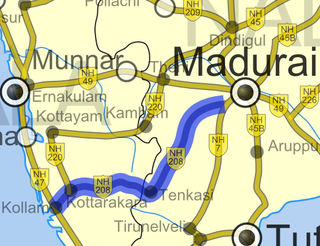
National Highway 744 or NH 744 is a National Highway in Southern India that links Kollam (Quilon) in Kerala with Madurai in Tamil Nadu. Starting from NH 66 at Chinnakkada in Kollam, it joins Tirumangalam in Madurai at National Highway 44 (India).
National Highway 49 was a National Highway in southern India under former numbering system.. It traversed coast-to-coast linking Kochi in Kerala with Dhanushkodi in Tamil Nadu. It crosses the famous Pamban Bridge before crossing into Rameswaram island. The total length runs up to 440 km (270 mi). The 5 km road between Mukundarayar Chathiram and Dhanuskodi was destroyed during the 1963 cyclone and was rebuilt.
Adimali is a town in the Idukki district of Kerala, India. National Highway 185 is a highway in India running from Adimali to Kumily through Kattappana and ends in Adoor in Kerala. Adimaly is located on the National Highway 49, now NH 85, known as Kochi-Dhanushkodi National Highway, earlier known as the Kochi Madhura Highway (India) connecting Kochi and Madurai, India. From Adimaly, it is only 27 kilometers to Munnar, which is a famous hill station. The waterfalls Cheeyappara, Adimali waterfalls and Valara are located nearby. Pepper and cocoa cultivation is the main agricultural activity of this place. The Ponmudi Dam was constructed in 1963 across the Panniar river, nearly 15 km southeast of Adimali, on the way to Rajakkad.Thopramkudy is the nearest town. Adimali is known for its proximity to Munnar and natural environment. Adimali has almost all the basic facilities like roads, super markets, markets, educational institutions and hospitals.

Tamil Nadu, a state in South India, has a highly developed, dense, and modern transportation infrastructure, encompassing both public and private transport. Its capital city, Chennai is well-connected by land, sea, and air and serves as a major hub for entry into South India.

Kundannoor is a region in the city of Kochi, in the state of Kerala, India. It is located around 3.5 km from Vytilla Junction and around 7 km from Ernakulam Junction Railway Station. Kundanoor is located on the busiest road of the city and state, the Kochi Bypass, at the junction of three National Highways, namely NH 66, NH 85 and NH 966B. NH 966B is the second shortest National highway in India.

State Highway 19 runs in Tirupur District of Tamil Nadu, India. It connects Avinashi(Coimbatore) with Kochi Road. It will provide an additional connectivity with the Eastern suburban places of Coimbatore like Avinashi, Palladam, Tirupur with Kochi.

National Highway 544, commonly referred to as NH 544, is a 340-kilometre-long (210 mi) National Highway in South India connecting Salem city in Tamil Nadu to the city of Kochi in Kerala. It is also called the Salem-Kochi Highway. The highway runs through the states of Kerala and Tamil Nadu, connecting various important cities and towns such as Salem, Erode, Coimbatore, Palakkad, Thrissur and Kochi. It is a spur of National Highway 44, which forms the North South Corridor of the National Highway network of India.It passes south of Coimbatore. NH544 is the only highway in kerala which is fully 4lane including kuthiran Road Tunnel. It was formerly designated National Highway 47.
Coimbatore is a city in the state of Tamil Nadu, India. Most transportation in the city and suburbs is over its road network. Coimbatore is well connected to most cities and towns in India by road, rail, and air, but not through waterways. The city has successful transport infrastructure compared to other Indian cities, though road infrastructures are not well maintained and developed according to the growing needs of transport, making traffic congestion a major problem in the city. A comprehensive transport development plan has been made to address many traffic problems.
National Highways 183 is located in India. It connects Kollam High school Jn in Kerala with Dindigul in Tamil Nadu. Starting from Kollam it runs northwards and turns east at Kottayam and runs along the northern border of Periyar Wildlife Sanctuary before crossing the border into Tamil Nadu and end near Dindigul, where it joins NH 83(Coimbatore - Nagapattinam). This highway was previously known as NH 220.
National Highway 66, commonly referred to as NH 66, is a 4 lane 1,608 km (999 mi) long busy National Highway that runs roughly north–south along the western coast of India, parallel to the Western Ghats. It connects Panvel to Cape Comorin (Kanyakumari), passing through the states of Maharashtra, Goa, Karnataka, Kerala and Tamil Nadu.

National Highway 79 is a National Highway in India entirely within the state of Tamil Nadu. It runs between Ulundurpettai and Salem in the Indian state of Tamil Nadu for a total of 134 km (83 mi). It connects with NH 44 and NH 544 at Salem. NH 79 connects NH 68 and SH 69 at Ulundurpettai and SH 6 at kallakurichi. It was upgraded to a dual carriageway road in two phases on a Build-operate-transfer basis by Reliance Infrastructure and Maytas.

National Highway 966A or NH 966A starts at Kalamassery and ends at Vallarpadam International Container Transhipment Terminal in Kochi, Kerala, India. The total length of the highway is 17 km (11 mi) and runs only inside Kochi.

The district capital of Wayanad is Kalpetta town. Kalpetta has very good road connectivity with the rest of Kerala and neighboring South Indian cities. National Highway 766 (India) NH766 connects Kalpetta with Kozhikode and Mysore. State Highways connect Kalpetta with Ooty in Tamil Nadu and Madikeri in Karnataka.
National Highway 785, commonly referred to as NH 785 is a national highway in India. It is a spur road of National Highway 85. NH-785 traverses the state of Tamil Nadu in India.


