
The Grand Trunk Road is one of Asia's oldest and longest major roads. For at least 2,500 years it has linked Central Asia to the Indian subcontinent. It runs roughly 3,655 km (2,271 mi) from Teknaf, Bangladesh on the border with Myanmar west to Kabul, Afghanistan, passing through Chittagong and Dhaka in Bangladesh, Kolkata, Kanpur, Agra, Aligarh, Delhi, Amritsar in India, and Lahore, Rawalpindi, and Peshawar in Pakistan.

The Golden Quadrilateral is a national highway network connecting several major industrial, agricultural and cultural centres of India. It forms a quadrilateral with all the four major metro cities of India forming the vertices, viz., Delhi (north), Kolkata (east), Mumbai (west) and Chennai (south). Other major cities connected by this network include Ahmedabad, Bengaluru, Balasore, Bhadrak, Bhubaneswar, Cuttack, Berhampur, Durgapur, Faridabad, Guntur, Gurugram, Jaipur, Kanpur, Pune, Kolhapur, Surat, Vijayawada, Eluru, Ajmer, Visakhapatnam, Bodhgaya, Varanasi, Prayagraj, Agra, Mathura, Dhanbad, Gandhinagar, Udaipur, and Vadodara. The main objective of these super highways is to reduce the travel time between the major cities of India, running roughly along the perimeter of the country. The North–South corridor linking Srinagar and Kanyakumari, and East–West corridor linking Silchar (Assam) and Porbandar (Gujarat) are additional projects. These highway projects are implemented by the National Highway Authority Of India (NHAI). At 5,846 kilometres (3,633 mi), it is the largest highway project in India and the fifth longest in the world. It is the first phase of the National Highways Development Project (NHDP), and consists of two, four, and six-lane express highways, built at a cost of ₹600 billion (US$7.2 billion). The project was planned in 1999, launched in 2001, and was completed in 7 January 2012.

The national highways in India are a network of limited access roads owned by the Ministry of Road Transport and Highways. National highways have flyover access or some controlled-access, where entrance and exit is through the side of the flyover. At each highway intersection, flyovers are provided to bypass the traffic on the city, town, or village. These highways are designed for speeds of 100 km/h. Some national highways have interchanges in between, but do not have total controlled-access throughout the highways. The highways are constructed and managed by the Central Public Works Department (CPWD), the National Highways and Infrastructure Development Corporation Limited (NHIDCL), and the public works departments (PWD) of state governments. Currently, the longest national highway in India is National Highway 44 at 4,112 km. India started four laning of major national highways with the National Highway Development Project (NHDP). As of March 2022 India has approximately 35,000 km of four laned National highways.

Roads in India are an important mode of transport in India. India has a network of over 6,331,791 kilometres (3,934,393 mi) of roads. This is the second-largest road network in the world, after the United States. At of roads per square kilometre of land, the quantitative density of India's road network is equal to that of Hong Kong, and substantially higher than the United States, China, Brazil and Russia. Adjusted for its large population, India has approximately 5.13 kilometres (3.19 mi) of roads per 1,000 people, which is much lower than United States 20.5 kilometres (12.7 mi) but higher than that of China 3.6 kilometres (2.2 mi). India's road network carries over 71% of its freight and about 85% of passenger traffic.

State Route 303 (SR 303) is a 75.71-mile-long (121.84 km) Ohio State Route that runs between Wakeman and Windham in the US state of Ohio. The highway is not listed on the National Highway System. Most of the route is a rural two-lane highway and passes through farmland, woodland, and residential properties. The route passes through the Cuyahoga Valley National Park. For some of its path, SR 303 runs generally parallel to the south of the Ohio Turnpike. SR 303 was first signed in 1932 on a section of the same alignment as today. The highway was extended towards the west in 1935. The highway was extended again in 1937. The eastern terminus was rerouted to its current intersection in the mid-1950s.
Highway 303 is a provincial highway in the Canadian province of Saskatchewan. It runs from Highway 16, approximately 1.7 kilometres (1.1 mi) east of Lloydminster city limits, to Highway 26 in Turtleford. It is about 82 kilometres (51 mi) long.
Harichandapuram is an Indian village and panchayat, located in Kotabommali mandal in Srikakulam district, Andhra Pradesh, India.
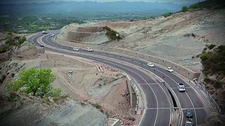
National Highway 44 is a major north–south National Highway in India and is the longest in the country.

State Route 303 (SR 303) is a 9.27-mile (14.92 km) state highway in Kitsap County, located in the U.S. state of Washington. The highway connects SR 304 in Bremerton to an interchange with SR 3 in Silverdale. SR 303 crosses the Port Washington Narrows on the Warren Avenue Bridge in Bremerton and becomes a grade-separated freeway bypass of Silverdale. The route has existed as unpaved roads since the 1930s and was signed as Secondary State Highway 21B (SSH 21B) in 1937. SSH 21B connected Bremerton to Keyport and had a branch to Illahee State Park added in 1961. After the 1964 highway renumbering, SSH 21B became SR 303 from Bremerton to Keyport and SR 306 from Bremerton to Illahee State Park. SR 303 was shortened in 1971, to include SR 308, and in 1991, re-routing the highway onto the new Silverdale freeway. SR 303 also had a spur route in Bremerton that served the Manette Bridge until 1991.

National Route 303 is a national highway of Japan connecting Gifu, Gifu and Wakasa, Fukui in Japan. The highway has a total length of 122.8 km (76.3 mi).
National Highway 144 is a national highway in the union territory of Jammu and Kashmir of India. NH-144 is a branch of National Highway 44.

National Highway 3, or NH 3, is a national highway in India. It starts from Atari adjacent to India-Pakistan border and near Amritsar and terminates at Leh in Ladakh, via Manali in Himachal Pradesh.
National Highway 52, is a fourth longest National Highway in India. it connects Sangrur, Punjab to Ankola, Karnataka. The national highway 52 was numbered after amalgamating many existing national highways of India. The old highway numbered NH-63 was from Ankola in Karnataka state to Gooty in Andhra pradesh state. The highway 52 starts at the junction of National Highway 66 at Ankola and moves up to Arebail ghat of Western ghats and then to Yellapura and further to Hubballi (Hubli) city. Some stretch of old national highway 13 from Vijayapura to Solapur was joined with NH-52. Lorries coming Hubballi city to Karwar sea port and New Mangalore sea port (NMPT) use this highway.The road stretch from Ankola to Yellapura is through forests of Western ghats of India. Biaora - Dhule section of this highway is part of the Legendary Agra-Bombay Road, also known as AB Road
National Highway 66, commonly referred to as NH 66, is a mostly 4 lane 1640 km long busy National Highway that runs roughly north–south along the western coast of India, parallel to the Western Ghats. It connects Panvel, a city east of Mumbai (Bombay) to Cape Comorin (Kanyakumari) via Cochin (Kochi), passing through the states of Maharashtra, Goa, Karnataka, Kerala and Tamil Nadu.

National Highway 503, commonly referred to as NH 503, is a highway connecting the city of Dharamshala to Mubarakpur in Himachal Pradesh. NH503 has been extended from Mubarakpur to Kiratpur in Punjab. The route of NH503 is extended from Mataur Kangra to Mcleodganj Dharamshala.

National Highway 19 is a national highway in India. It was previously referred to as Delhi–Kolkata Road and is one of the busiest national highways in India. After renumbering of national highways, Delhi to Agra route is now national highway 44 and Agra to Kolkata route is numbered national highway 19. It constitutes a major portion of the historical Grand Trunk Road. It is also part of AH1 of Asian Highway Network, that traverses from Japan to Turkey.

State Highway 4 is a state highway in West Bengal, India.


