Bageshwar is a district of Uttarakhand state in northern India. The town of Bageshwar is the district headquarters. Prior to its establishment as a district in 1997 it was part of Almora district.

Bageshwar is a town and a municipal board in Bageshwar district in the state of Uttarakhand, India. It is located at a distance of 470 km from the National Capital New Delhi and 332 km from the State Capital Dehradun. Bageshwar is known for its scenic environment, glaciers, rivers and temples. It is also the administrative headquarters of Bageshwar district.

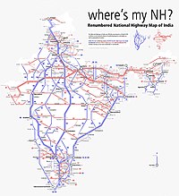
The North–South–East–West r (NS-EW) is the largest ongoing highway project in India. It is the second phase of the National Highways Development Project (NHDP), and consists of building 7300 kilometers of four/six lane highways associating Srinagar, Kanyakumari, Kochi, Porbandar and Silchar, at a cost of US$12.317 billion ₹1000000000000(One lakh Crore INR). As of 19 March 2024, 6875 of the 7142 kilometers project has been finished.
Kausani is a hill station and Village situated in Bageshwar district in the state of Uttarakhand, India. It is known for its scenery and its 300 km-wide panoramic view of Himalayan peaks like Trisul, Nanda Devi and Panchchuli. Mahatma Gandhi called this place the 'Switzerland of India', due to similarity in landscapes.

National Highway 30 is a primary national highway in India. NH 30 connects Sitarganj in Uttarakhand with Ibrahimpatnam, Vijayawada in Andhra Pradesh. The total length of this highway is 1,984.3 km (1,233.0 mi). It starts at the junction of NH 9 at Sitarganj and ends at the junction of NH 65 at Ibrahimpatnam, Vijayawada. Development of Ibrahimpatnam-Jagadalpur Route is under process. Rajdeep Rohan joint venture is the contract agency for this project. Second bridge was completed on 17 April 2024 at pilgrimage city of Bhadrachalam which is famous for temple of Lord Shri Rama. NH-30 runs through the states of Uttarakhand, Uttar Pradesh, Madhya Pradesh, Chhattisgarh, Telangana and Andhra Pradesh in India.

Chaukhutia is a town in Almora district of Uttarakhand. It is located on the bank of the river Ramganga, and derives its name from a Kumaoni word "Chau-khut" which means four feet. In Chaukhutia's context, 'four feet' means four ways or directions. The first way is towards Ramnagar, second towards Karanprayag, third towards Ranikhet and Almora and the fourth way is towards Tadagtaal, Kheera.

Nawab Yusuf Road is situated in the Indian state of Uttar Pradesh, it connects Jaunpur to Ayodhya via Shahganj and Akbarpur.

Bagnath Temple is an ancient shrine dedicated to Shiva, situated in the Bageshwar city at the confluence of Sarayu and Gomati rivers. Bagnath Temple is festooned with bells of all sizes and features impressive carvings. It is the most famous Temple in Bageshwar District. It is flooded with devotees on the occasion of Shivratri. The city of Bageshwar gets its name from this Temple.

National Highway 7 is a highway connecting Fazilka (Punjab) to Mana (Uttarakhand) in India. It passes through the Indian states of Punjab, Haryana, Himachal Pradesh, and Uttarakhand.
National Highway 344 is a national highway in India running from Ambala in Haryana to Roorkee in Uttarakhand. It is a secondary route of National Highway 44. NH-344 runs in the states of Haryana, Punjab, Uttar Pradesh and Uttarakhand in India.
National Highway 109, , is a highway in India which runs in the Indian state of Uttarakhand. It is one of the most important routes, connecting the entire Kumaon region to the state as well as the country. It is also the major route towards the hill stations such as Nainital, Kausani, Ranikhet, Mukteswar and Almora from Delhi. Previously known as NH 87, it was renumbered as NH 109 in 2010. The northern terminal is at NH 7 near Karnaprayag and the southern terminal is at National Highway 9 near Rudrapur. More than 10,000 vehicles travel through NH-109 in tourist season.

National Highway 309A, commonly referred to as NH 309A, is a single lane highway connecting the city of Rameshwar to Almora in the Indian State of Uttarakhand. Before the creation of Uttarakhand state in 2000, the Almora-Bageshwar stretch of this Highway was a part of the State Highway 37 of Uttar Pradesh, which ran from Bageshwar to Bareilly.
Vijaypur, officially known as Bijaypur is a hill station and village situated in Bageshwar district in the state of Uttarakhand, India. It is located at a distance of 30 km from Bageshwar and 5 km from Kanda; amidst dense Pine Forests on the Bageshwar-Chaukori Highway.
National Highway 731K, commonly referred to as NH 731K is a national highway in India. It is a secondary route of National Highway 31. NH-731K runs in the states of Uttar Pradesh and Uttarakhand in India.

Jamshedpur-Ranchi-Hazaribagh-Barhi Highway is a four-lane state highway in Jharkhand constructed on NH 20, NH 43 and Ranchi Ring Road. It was started constructing in 2009 and completed in 2012. It connects Ranchi, capital of Jharkhand, to Hazaribagh in Jharkhand. It is extended up to Ranchi - Jamshedpur Expressway in Jharkhand and Barhi in Jharkhand in 2020 and giving it a length of 231 km. A ten km four-lane bypass has been constructed near Hazaribagh and a 40 km six-lane bypass near Ranchi to decrease the pressure of Traffic in both the cities. It is proposed to be extended to Koderma till 2022.
The Uttarakhand Metro is a light rapid transit system proposed for the city of Dehradun, India. The Unified Metropolitan Transport Authority (UMTA) approved 73 km long Deharadun–Haridwar–Rishikesh Metro Rail corridor in Uttarakhand in June 2020.The project will be executed by the Uttarakhand Metro Rail Corporation Limited (UkMRC), a special purpose vehicle and venture of the Government of Uttarakhand. The first phase, or Line-1, will be 32 km long with 10 stations, starting near the Jatwara Bridge in Jwalapur, running parallel to the NH-34 Haridwar-Rishikesh highway, and ending at Rishikesh’s Chandrabhaga Bridge. The second phase, or Line-2, will be 41 km long, following National Highway-7 from Nepali Farm to Dehradun’s Inter-State Bus Terminal (ISBT) via the Vidhan Sabha. The estimated cost of the project would be ₹ 40,150 crore.
National Highway 530B, commonly referred to as NH 530B is a national highway in India. It is a secondary route of National Highway 30. NH-530B runs completely in the state of Uttar Pradesh in India. The Highway was Notified on 06 Mar 2018, prior to which, it was a part of UP State Highway 33.
Tharali is a tehsil in the Chamoli district of the Indian state of Uttarakhand. It is located on the banks of the Pindar River.
Parwati Das is an Indian politician. She is currently serving as a member of the Uttarakhand Legislative Assembly from the Bageshwar Assembly constituency. She is the ninth female MLA in the assembly and the fifth MLA of the Bharatiya Janata Party from the Bageshwar constituency. She is the wife of former MLA Chandan Ram Das.