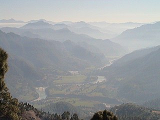
Jauljibi (Jaul Jibi) is a small market town dominated by its bazaar on the Indo-Nepal border, situated at the confluences of the Kali and Gori rivers.[1]Jauljibi refers to the villages and bazaars on both sides of the river. The Nepal-side village in Sudurpashchim is much smaller than the Indian one in Uttarakhand. A suspension bridge, rebuilt several times, across the Kali has joined the bazaars and the people of both countries for over a hundred years.
Jauljibi is a crossroads where the main road of the Indian district, the Pithoragarh-Jauljibi-Darchula-Tawaghat road which follows the Kali, is joined from the north by the Munsiary-Madkot-Jauljibi road, which follows the Gori River.[2] It is the confluence of trade routes from Nepal to the east, Askot to the west, Johar Pass to Tibet to the north, and the Darma Valley to the northeast.[3]
The town is famous for its annual trade fair held in November, popularly known as the Kumauni Festival.[4] Thousands of people throng to the fair from the neighboring villages and districts to trade and to enjoy music, singing, dancing and food.[4] The trade fair was initiated in 1914 by the Rajbar (zamindar) of Askot.[3]
Until a permanent bridge was built in the 1960s, a bridge across the Kali was rebuilt in November of each year after the monsoon (summer rains), where in July the increased flow in the Kali had swept away the previous year's bridge.[3] On 17 November 1974, during the annual Kumauni Festival and trade fair, the bridge across the Kail collapsed.[5]Flooding in June 2013 again sweep away the suspension bridge.[6]
Notes and references
↑ Kapoor, A. K. (1994). "Ecology and Tribals in Central Himalaya". In Kapoor, A. K.; Kapoor, Satwanti (eds.). Ecology and Man in the Himalayas. New Delhi: MD Publications. p.69–90, page 77. ISBN978-81-85880-16-7.
↑ Kapadia, Harish (1999). Across Peaks & Passes in Kumaun Himalaya. New Delhi: Indus Publishing. p.219. ISBN978-81-7387-096-5.
1 2 3 Pande, Vasudha (2021). "Borders in an Age of Empire and Nation-States". In Ibrahim, Farhana; Kothiyal, Tanuja (eds.). South Asian Borderlands: Mobility, History, Affect. Cambridge, England: Cambridge University Press. pp.44–79, page 56. ISBN978-1-108-96757-0.
1 2 Yadav, Karishma, ed. (2015). "Fairs and Festivals". Know Your State Uttarakhand. Meerut, Uttar Pradesh: Arihant Publications. pp.165–179, page 166. ISBN978-93-5094-207-9.
↑ "Government of U.P. on 18th Nov. 1974". Parliamentary Debates: Official Report. 90 (11/12). Government of India: 97.
↑ Nishank, Ramesh Pokhriyal (2021). Amidst the Holocaust. Diamond Pocket Books. p.223. ISBN978-93-5486-768-2. originally published in 2018 in Hindi as प्रलय के बीच.
Kumaon is a revenue and administrative division in the Indian State of Uttarakhand. It spans over the eastern half of the state and is bounded on the north by Tibet, on the east by Nepal, on the south by the state of Uttar Pradesh, and on the west by Garhwal. Kumaon comprises six districts of the state: Almora, Bageshwar, Champawat, Nainital, Pithoragarh and Udham Singh Nagar.
Kumaoni is an Indo-Aryan language spoken by over two million people of the Kumaon region of the state of Uttarakhand in northern India and parts of Doti region in Western Nepal. As per 1961 survey there were 1,030,254 Kumaoni speakers in India. The number of speakers increased to 2.2 million in 2011.
Pithoragarh district is the easternmost district in the state of Uttarakhand. It is located in the Himalayas and has an area of 7,110 km2 (2,750 sq mi) and a population of 483,439. The city of Pithoragarh, located in Saur Valley, is its headquarters. The district is within the Kumaon division of Uttarakhand state. The Tibet plateau is situated to the north and Nepal is to the east. The Kali River which originates from the Kalagiri Mountain flows south, forming the eastern border with Nepal. The Hindu pilgrimage route for Mount Kailash-Lake Manasarovar passes through this district via Lipulekh Pass in the greater Himalayas. The district is administratively divided into six Tehsils: Munsyari; Dharchula; Didihat; Berinag; Gangolihat; and Pithoragarh. Naini Saini Airport is the nearest civil airport, but it does not have a regular scheduled commercial passenger service. The mineral deposits present in the district are magnesium ore, copper ore, limestone, and slate. There are 11 tehsils.
Munsiyari is the name of the sub-division headquarters, a conglomeration of revenue villages and it also refers to the entire region as Munsiyari Tehsil and Sub Division in the Pithoragarh District in the hill-state of Uttarakhand, India.
Askot or Askote is a small Himalayan town in Pithoragarh district of Uttarakhand in India. It is the part of Kanalichhina development Block and Didihat Tehsil.
The Chand dynasty was a Hindu dynasty that ruled the Kumaon area in present-day Uttarakhand state of India, after the decline of the Katyuri rule. At times, their rule also extended to the western parts of present-day Nepal. Somchand, who claimed Chandravanshi Rajput ancestry, established the dynasty, establishing his capital at Rajbunga in present-day Champawat.
Bageshwar is a town and a municipal board in Bageshwar district in the state of Uttarakhand, India. It is located at a distance of 470 km from the National Capital New Delhi and 332 km from the State Capital Dehradun. Bageshwar is known for its scenic environment, glaciers, rivers and temples. It is also the administrative headquarters of Bageshwar district.
Darma valley is a Himalayan valley situated in the Pithoragarh District of Uttarakhand state of India. This valley is located in the eastern part of Uttarakhand at Kumaon division.
Kuti Valley is a Himalayan valley, an area administered by India and also claimed by Nepal, is situated in the Pithoragarh district of Uttrakhand state of India. It is the last valley before the border with Tibet. It runs along the Limpiyadhura Pass & Adi Kailash in northwest to Gunji in southeast axis, formed by the river Kuti Yankti, which is one of the headwaters of the Kali River. It is reached by the Pithoragagh-Lipulekh Pass Highway (PLPH).
Garkha is the Himalayan fertile and lush green mountain country in front of Askot region of Uttarakhand state of India in the Pithoragarh district. This region tilted from South West to North East. Literally in Kumauni it means the herds of cows. Well linked with roads with Ogla at its entry point. This place lies in the Kanalichhina development block of Didihat tehsil and sub division. This area is lies on the mountain on the northern slopes of western Himalayas. This place is full of Rhododendron, Quercus, Myrica and Pinus forests. In this place many villages lies between Dhanlek peak and Bagarihat and the plains of Titari on the left bank of river Kali on one at lower side. Once ruled by Rajbar of Askot and this place was long under the Gorkha Kings of Nepal. This area was the main area of commerce with river trade point at once flourshing trade city of Bagdihat, on the banks of river Kali.
Milam is the last village situated in Johar valley of Pithoragarh district in the state of Uttarakhand, India. The river Gori Ganga originates from Milam Glacier and flows past the village to meet with Kali ganga at Jauljibi.
Baijnath is a small town on the banks of the Gomati river in the Bageshwar district in Kumaon division of Uttarakhand, India. The place is most noted for its ancient temples, which have been recognized as Monuments of National Importance by the Archaeological Survey of India in Uttarakhand. Baijnath has been selected as one of the four places to be connected by the 'Shiva Heritage Circuit' in Kumaon, under the Swadesh Darshan Scheme of the Government of India.
Gori Ganga is a river in the Munsiari tehsil of the Pithoragarh District, part of the state of Uttarakhand in northern India. Its principal source is the Milam Glacier, just northeast of Nanda Devi along with the Glaciers of the Ralam River, and the Pyunshani and Uttari & Dakshini Balati Glaciers that lie on the western face of the Panchachuli Peaks.
Dr. Shekhar Pathak is a historian, editor, publisher, activist, and traveller from Uttarakhand, India. He is known for his extensive knowledge of the history of colonial and postcolonial social movements and contemporary environmental and social issues in Uttarakhand, and colonial exploration in the Himalayas and Tibet. He has also been engaged in activism for various social and environmental causes since the 1970s.
Johar Valley is a valley located in Pithoragarh district of Uttarakhand, India, along the Gori Ganga river. The valley used to be a major trade route with Tibet. The best known villages in the valley are Martoli and Milam.
The Sharda River is the downstream of Kali River that originates in the northern Uttarakhand state of India in the Great Himalayas on the eastern slopes of Nanda Devi massif, at an elevation of 3,600 m (11,800 ft) in the Pithoragarh district. It then flows between the Nepal and India border. Descending, it enters the Indo-Gangetic Plain at Brahmadev Mandi in Nepal, where it expands above the Sharda Barrage. From that point onward, it is known as the Sharda River. The river proceeds southeastward into India through northern Uttar Pradesh before merging with the Ghaghara River southwest of Bahraich, covering a distance of approximately 300 miles.
Bhotiyas are people of presumed Tibetan heritage that live along the Indo-Tibetan border in the upper reaches of the Great Himalayas, at elevations ranging from 6,500 feet (2,000 m) to 13,000 feet (4,000 m). In Uttarakhand, they inhabit seven river valleys, three in the Garhwal division and four in the Kumaon division. They follow Hinduism with Buddhism and traditionally speak West Himalayish languages related to the old Zhangzhung language. Their main traditional occupation used to be Indo-Tibetan trade, with limited amounts of agriculture and pastoralism. The Ido-Tibetan trade came to a halt following the 1962 Sino-Indian war, and was resumed only in the early 1990s under state-regulated mechanisms. Their major livelihood at present is the collection of medicinal and aromatic plants in the Himalayas. Many have also migrated out of their traditional habitats to towns at lower elevations. The traditional transhumance and pastoralism have also drastically reduced.
The Kalapani territory is an area under Indian administration as part of Pithoragarh district in the Kumaon Division of the Uttarakhand state, but it is also claimed by Nepal since 1997. According to Nepal's claim, it lies in Darchula district, Sudurpashchim Province. The territory represents part of the basin of the Kalapani river, one of the headwaters of the Kali River in the Himalayas at an altitude of 3600–5200 meters. The valley of Kalapani, with the Lipulekh Pass at the top, forms the Indian route to Kailash–Manasarovar, an ancient pilgrimage site. It is also the traditional trading route to Tibet for the Bhotiyas of Kumaon and the Tinkar valley of Nepal.
Uttarakhand is a state in the northern part of India. It is often referred to as the "Devbhumi" due to its religious significance and numerous Hindu temples and pilgrimage sites found throughout the state. As a result, religious tourism forms a major portion of the tourism in the state. Uttarakhand is known for the natural environment of the Himalayas. 2019 Tourist Arrivals Domestic – 40,000,000 per/year and Foreigner – 150,000 per year. Tourism business in Uttarakhand generated ₹ 23,000 crores during 2013–14.
The Sarju, also known as Sarayu, is a major river draining Central Kumaon region in the Indian state of Uttarakhand. Originating from Sarmul, Sarju flows through the cities of Kapkot, Bageshwar and Seraghat before joining Mahakali at Pancheshwar. The Sarju is the largest tributary of the Sharda River. The river forms the South-eastern border between the districts of Pithoragarh and Almora. Temperate and sub-Tropical forests cover the entire Catchment area of the River.
This page is based on this Wikipedia article Text is available under the CC BY-SA 4.0 license; additional terms may apply. Images, videos and audio are available under their respective licenses.