
Pithoragarh district is the easternmost district in the state of Uttarakhand. It is located in the Himalayas and has an area of 7,110 km2 (2,750 sq mi) and a population of 483,439. The city of Pithoragarh, located in Saur Valley, is its headquarters. The district is within the Kumaon division of Uttarakhand state. The Tibet plateau is situated to the north and Nepal is to the east. The Kali River which originates from the Kalagiri Mountain flows south, forming the eastern border with Nepal. The Hindu pilgrimage route for Mount Kailash-Lake Manasarovar passes through this district via Lipulekh Pass in the greater Himalayas. The district is administratively divided into six Tehsils: Munsyari; Dharchula; Didihat; Berinag; Gangolihat; and Pithoragarh. Naini Saini Airport is the nearest civil airport, but it does not have a regular scheduled commercial passenger service. The mineral deposits present in the district are magnesium ore, copper ore, limestone, and slate. There are 11 tehsils.
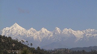
The Panchachuli (पंचाचुली) peaks are a group of five snow-capped Himalayan peaks lying at the end of the eastern Kumaon region, near the Dugtu village in Darma valley. The peaks have altitudes ranging from 6,334 metres (20,781 ft) to 6,904 metres (22,651 ft). They form the watershed between the Gori and the Darmaganga valleys. Panchachuli is also located on the Gori Ganga-Lassar Yankti divide. The group lies 138 km (86 mi) from Pithoragarh. The first ascent of this range was done by an Indo-Tibetan Border Police (ITBP) team in 1972, via the Uttari Balati glacier, led by Major Hukam Singh.

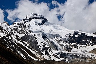
Om Parvat is a mountain located in Pithoragarh district, Uttarakhand, India. Om Parvat's peak elevation is 5,590 m (18,340 ft) above sea level.
Kalabaland Glacier of Himalaya is situated in the eastern Kumaun of the Pithoragarh district of Uttarakhand state of India.
Sin La is a high Himalayan mountain pass located in the eastern Kumaon in Pithoragarh District of Uttarakhand state in India.
Chiring We is the Himalayan peak situated in eastern Kumaun of the Pithoragarh district of Uttarakhand state in India. The altitude of the peak is 6,559 m. Chiring We is the highest peak above the Kalabaland Glacier. Chiring We massif, which include peaks like Bamba Dhura (6,334 m), Suli Top (6,300 m), Trigal (5,983 m), Suitilla (6,373 m), separates Lassar Yankti valley from Kalabaland valley. The peak literally means 'Mountain of long life'. The route is through glaciers of Kalabaland, Sankalpa and Yankchar, icefall, crevasses, ice-pinnacles, ice walls and sharp ridges. First ascent to this peak was made in 1979 by an Indian team led by Harish Kapadia via northeast ridge.
Kuti Valley is a Himalayan valley, an area administered by India and also claimed by Nepal, is situated in the Pithoragarh district of Uttrakhand state of India. It is the last valley before the border with Tibet. It runs along the Limpiyadhura Pass & Adi Kailash in northwest to Gunji in southeast axis, formed by the river Kuti Yankti, which is one of the headwaters of the Kali River. It is reached by the Pithoragagh-Lipulekh Pass Highway (PLPH).
Nagalaphu is a Himalayan mountain peak located in the Pithoragarh district of Uttarakhand state in India.
Sona Glacier is the Himalayan glacier situated in the eastern part of Uttarakhand in the Pithoragarh district of India.

Panchchuli Glacier is a Himalayan glacier, situated in the Pithoragarh district of Uttarakhand, India.
Gyanema or Gya'nyima (Tibetan: རྒྱ་ཉི་མ, Wylie: rgya nyi ma, THL: gya nyi ma) is a large plain at the border between the Zanda County and Burang County in western Tibet, which was once used for an annual market of Indo-Tibetan trade. The border has been sealed and the market shut down since the Sino-Indian War of 1962. At the present time, there is only a small settlement at the western edge of the plain called Xilanta, where China operates a military outpost.
Milam is the last village situated in Johar valley of Pithoragarh district in the state of Uttarakhand, India. The river Gori Ganga originates from Milam Glacier and flows past the village to meet with Kali ganga at Jauljibi.

Gori Ganga is a river in the Munsiari tehsil of the Pithoragarh District, part of the state of Uttarakhand in northern India. Its principal source is the Milam Glacier, just northeast of Nanda Devi along with the Glaciers of the Ralam River, and the Pyunshani and Uttari & Dakshini Balati Glaciers that lie on the western face of the Panchachuli Peaks.

Johar Valley is a valley located in Pithoragarh district of Uttarakhand, India, along the Gori Ganga river. The valley used to be a major trade route with Tibet. The best known villages in the valley are Martoli and Milam.

The Sharda River is the downstream of Kali River that originates in the northern Uttarakhand state of India in the Great Himalayas on the eastern slopes of Nanda Devi massif, at an elevation of 3,600 m (11,800 ft) in the Pithoragarh district. It then flows between the Nepal and India border. Descending, it enters the Indo-Gangetic Plain at Brahmadev Mandi in Nepal, where it expands above the Sharda Barrage. From that point onward, it is known as the Sharda River. The river proceeds southeastward into India through northern Uttar Pradesh before merging with the Ghaghara River southwest of Bahraich, covering a distance of approximately 300 miles.
Bhotiyas are people of presumed Tibetan heritage that live along the Indo-Tibetan border in the upper reaches of the Great Himalayas, at elevations ranging from 6,500 feet (2,000 m) to 13,000 feet (4,000 m). In Uttarakhand, they inhabit seven river valleys, three in the Garhwal division and four in the Kumaon division. They follow Hinduism with Buddhism and traditionally speak West Himalayish languages related to the old Zhangzhung language. Their main traditional occupation used to be Indo-Tibetan trade, with limited amounts of agriculture and pastoralism. The Indo-Tibetan trade came to a halt following the 1962 Sino-Indian war, and was resumed only in the early 1990s under state-regulated mechanisms. Their major livelihood at present is the collection of medicinal and aromatic plants in the Himalayas. Many have also migrated out of their traditional habitats to towns at lower elevations. The traditional transhumance and pastoralism have also drastically reduced.
The Kalapani territory is an area under Indian administration as part of Pithoragarh district in the Kumaon Division of the Uttarakhand state, but it is also claimed by Nepal since 1997. According to Nepal's claim, it lies in Darchula district, Sudurpashchim Province. The territory represents part of the basin of the Kalapani river, one of the headwaters of the Kali River in the Himalayas at an altitude of 3600–5200 meters. The valley of Kalapani, with the Lipulekh Pass at the top, forms the Indian route to Kailash–Manasarovar, an ancient pilgrimage site. It is also the traditional trading route to Tibet for the Bhotiyas of Kumaon and the Tinkar valley of Nepal.
Gunji is a small village in Uttarakhand of India. It is administered by India, but disputed by Nepal. It is near the borders of Tibet and Nepal and the confluence of the Kuthi Yankti and Kalapani River, at the east end of the Kuthi Valley. It is officially listed in the map of India. As of now Gunji, Kuti, and Nabhi villages belong to India. The village is on the traditional Indian/Nepalese route to Kailas–Manasarovar.
Adi Kailash, also known as Shiva Kailash, Chota Kailash, Baba Kailash or Jonglingkong Peak, is a mountain located in the Himalayan mountain range in the Pithoragarh district of Uttarakhand, India. It is the second most important peak among the group of five separate peaks in Himalayas in separate locations collectively known as the Panch Kailash or "Five Kailashas", others being Mount Kailash in the first place, Shikhar Kailash in the third, Kinnaur Kailash in the fourth and Manimahesh Kailash in the fifth place in terms of importance. Gauri Kund and Parvati Tal glacial lakes are at the base of the Adi Parvat.
Tinkar is a village in the Byans Rural Municipality of Darchula District in the Sudurpashchim province of Nepal. It is named after the Tinkar Khola river, a tributary of the Mahakali River, which it joins near the village of Chhangru.
