Ramganga

Last updated

Ramganga is a tributary of the river Ganges, originating in Uttarakhand state, India.

Contents

Ramganga West

Ramganga West
Ramganga, Moradabad.jpg
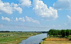
Ramganga near Moradabad, Uttar Pradesh
Location
Country India
State Uttarakhand, Uttar Pradesh
Region North India
Physical characteristics
Source Dudhatoli
  location Dudhatoli range, Pauri Garhwal, Uttarakhand, India
Mouth Ganges
  location
Hardoi district, Uttar Pradesh, India
  elevation
130 m (430 ft)
Length596 km (370 mi)
Basin size30,641 km2 (11,831 sq mi)
Discharge 
  location 27°10′41″N79°50′39″E / 27.177996°N 79.844112°E / 27.177996; 79.844112
  average900 m3/s (32,000 cu ft/s) [1]

Ramganga West River originates from Dudhatoli or Doodhatoli ranges

Course

The Ramganga River originates in the southern slopes of Dudhatoli Hill in Chamoli district of the Indian state of Uttarakhand. The source of the river, known as "Diwali Khal", is located in Gairsain tehsil at 30°05′00″N79°18′00″E / 30.08333°N 79.30000°E / 30.08333; 79.30000 . The river flows by the town of Gairsain, however the town is located at a much higher altitude than the river. The river then enters the Almora district of Kumaon through a deep and narrow valley in Chaukhutia tehsil. Emerging from there, it turns southwest and receives the Tadagatal River, wandering widely around the southeastern boundary of Lohabagarhi. It then proceeds further in the same direction and reaches Ganai, where it receives the Kharogad coming from Dunagiri from the left and Khetasargad coming from Pandnakhal from the right.

Coming out of Ganai, it flows towards the Talla Giwar region, where there is an open valley with alluvial land along and around the river, which is extensively cultivated and irrigated by the waters of the river. After Masi, the valley shrinks to some extent, but some fertile plains are still found up to the Briddhakedar temple. Here it receives the Vinod River, which originates from Chaukot, and from this point onwards the flow of the river turns southwards, and mountains filled with fertile soil and rocks can be seen on either side of the river. Eleven miles further from Masi, it reaches Bhikiyasain, where it receives the Gagas from the east and Naurargad from the south. Here the valley widens once again, but irrigation still depends mainly on minor streams. From Bhikiyasain the river takes a sharp turn towards the west and receives Nail River from Salt and Devgad from Garhwal. It forms the boundary of Almora and Pauri Garhwal districts to some extent after the Marchula Bridge. The river then enters Bhabar and flows westward from Patli Dun into the Jim Corbett National Park. It receives Mandal River near Kandanala.

Calm and Clear.jpg
River in Corbett National Park.jpg
Wild Solitude.jpg
Bright water.jpg
Elephants in Ramganga River, Corbett TR, June 2017, AJT Johnsingh. P1120858.JPG
The Ramganga in the Jim Corbett National Park.

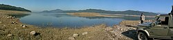
Ramganga, which is already a large river now, enters the plains at Kalagarh in Bijnor district of Uttar Pradesh, where a dam has been constructed on the river for the purpose of irrigation and hydroelectric production. About 15 miles from here it is joined by the Khoh, after which it enters the Moradabad district, where on the alluvial lowlands it flows in a southeastern direction with a very rapid flow, and forms the boundary between Thakurdwara and Kanth tehsils. The Ramganga receives several tributaries in Moradabad, almost all on its left bank, most of which are Tarai streams flowing towards south or south-west. The first among them is the Phika, which rises in the Kumaon hills and joins the Ramganga near Surjannagar. The Khalia stream, which drains the north-western part of Thakurdwara joins the Ramganga at Daulatpur Tigri. After receiving the Dhela river at Bhojpur, the Ramganga flows through the city of Moradabad, which is situated on its right bank, and receives the Rajera river near Dalpatpur. The river then continues further towards Rampur district, where it receives the Koshi river near Chamraul in Shahabad tehsil. It crosses Rampur with the same direction and strong currents as Moradabad and reaches Bareilly district.

Ramganga river at Bareilly Ramganga river Bareilly 01.jpg
Ramganga river at Bareilly

The Ramganga flows through the Bareilly district mainly in the southeastern direction. It receives the combined stream of Bhakra and Kichha (also called Baigul) from its left and the Gagan River from its right, after which it reaches near Bareilly city, which is located at a distance of about 10 km on its left side. Here it receives the Deoranian and Nakatiya rivers from its left – both rivers flow through Bareilly. An annual fair is held on the banks of the river on the occasion of Ganga Dussehra in Chaubari village near Bareilly in the month of September–October. Flowing further through Badaun and Shahjahanpur and Hardoi districts, it finally joins the Ganga river at village Katri Chandapur in the Hardoi district of U.P., after covering a total distance of about 373 miles.

Ramganga East

Ramganga East
Ramganga dhikala.jpg
Physical characteristics
Source 
  location Himalayas- Namik Glacier, Pithoragarh district
Mouth  
  location
Flows into River Kali

Another Ramganga called Ramganga East originates from the Namik Glacier in Pithoragarh district of Uttarakhand and flows towards South-East. [2] [3] The river is fed by numerous small and big rivers and finally joins river Sarju at Rameshwar near Ghat of Pithoragarh. [2] The Sarju in turn converges with the Kali (Sharda).[ citation needed ]

Related Research Articles

<span class="mw-page-title-main">Kumaon division</span> Administrative division in India

Kumaon is a revenue and administrative division in the Indian State of Uttarakhand. It spans over the eastern half of the state and is bounded on the north by Tibet, on the east by Nepal, on the south by the state of Uttar Pradesh, and on the west by Garhwal. Kumaon comprises six districts of the state: Almora, Bageshwar, Champawat, Nainital, Pithoragarh and Udham Singh Nagar.

<span class="mw-page-title-main">Haldwani</span> Metropolis in Uttarakhand, India

Haldwani is the largest city of Kumaon. It is also the third most populous city and largest commercial market in the Indian state of Uttarakhand. Haldwani is said to be the financial capital of Uttarakhand, having the most commercial, economic and industrial activities of the state. Haldwani is located in the Nainital District, and is one of its eight Subdivisions. The Haldwani Urban agglomeration has 232,060 people as of 2011, and is the third most populous UA in Uttarakhand, after Dehradun and Haridwar. Being situated in the immediate foothills of Kumaon Himalayas, the Kathgodam neighbourhood of Haldwani is known as the "Gateway to Kumaon".

Gairsain is a town in Chamoli district of the Indian state of Uttarakhand near state's summer capital Bhararisain. A town and Nagar Panchayat, Gairsain is situated at the eastern edge of the vast Dudhatoli mountain range, and is located in Chamoli district almost at the centre of the state, at a distance of approximately 250 kilometres from Dehradun. It is easily accessible from both the Garhwal and the Kumaon divisions, and in a way, acts as the bridge between the two regions. It is being considered as the future Permanent capital of Uttarakhand.

<span class="mw-page-title-main">Pithoragarh district</span> District of Uttarakhand in India

Pithoragarh district is the easternmost district in the state of Uttarakhand. It is located in the Himalayas and has an area of 7,110 km2 (2,750 sq mi) and a population of 483,439. The city of Pithoragarh, located in Saur Valley, is its headquarters. The district is within the Kumaon division of Uttarakhand state. The Tibet plateau is situated to the north and Nepal is to the east. The Kali River which originates from the Kalagiri Mountain flows south, forming the eastern border with Nepal. The Hindu pilgrimage route for Mount Kailash-Lake Manasarovar passes through this district via Lipulekh Pass in the greater Himalayas. The district is administratively divided into six Tehsils: Munsyari; Dharchula; Didihat; Berinag; Gangolihat; and Pithoragarh. Naini Saini Airport is the nearest civil airport, but it does not have a regular scheduled commercial passenger service. The mineral deposits present in the district are magnesium ore, copper ore, limestone, and slate. There are 11 tehsils.

<span class="mw-page-title-main">Didihat</span> Town in Uttarakhand, India

Didihat is a town and a Nagar Palika in Pithoragarh District in the state of Uttarakhand, India. It is one of the eleven administrative subdivisions of Pithoragarh district and also serves as its administrative headquarter. With a population of 6522, Didihat is located at a distance of 415 km (258 mi) from the state capital Dehradun.

Namik Glacier is situated in the Pithoragarh district of Uttarakhand state in India.

<span class="mw-page-title-main">Pithoragarh</span> Town in Uttarakhand, India

Pithoragarh is a Himalayan town with a Municipal Board in Pithoragarh district in the Indian state of Uttarakhand. It is the largest and unplanned town in Kumaon hills. It is an education hub of the hilly region as the town has Laxman Singh Mahar Govt.P.G.College, Seemant Institute of Technology, now known as Nanhi Pari Seemant Engineering Institute and a nursing college.

<span class="mw-page-title-main">Bageshwar district</span> District of Uttarakhand in India

Bageshwar is a district of Uttarakhand state in northern India. The town of Bageshwar is the district headquarters. Prior to its establishment as a district in 1997 it was part of Almora district.

<span class="mw-page-title-main">Bageshwar</span> Town in Uttarakhand, India

Bageshwar is a town and a municipal board in Bageshwar district in the state of Uttarakhand, India. It is located at a distance of 470 km from the National Capital New Delhi and 332 km from the State Capital Dehradun. Bageshwar is known for its scenic environment, glaciers, rivers and temples. It is also the administrative headquarters of Bageshwar district.

<span class="mw-page-title-main">Kashipur, Uttarakhand</span> City of Udham Singh Nagar district in the Indian state of Uttarakhand

Kashipur is a city of Udham Singh Nagar district in the Indian state of Uttarakhand, and one of its seven subdivisions. Located in the western part of Udham Singh Nagar district, it is Kumaun's third most populous city and the sixth most populous in Uttarakhand. According to the 2011 Census of India, the population is 121,623 for the city of Kashipur and 283,136 for Kashipur Tehsil. Kashipur also has IIM Kashipur, one of the thirteen Indian Institutes of Managements the government has set up during the Eleventh Five-year Plan.

<span class="mw-page-title-main">Chaukori</span> Village in Uttarakhand, India

Chaukori is a hill station in the Pithoragarh district set among the lofty peaks of the western Himalayan Range in the Kumaon Division of Uttarakhand, India. To its north is Tibet and to its south is Terai. The Mahakali River, running along its eastern boundary, forms the Indo-Nepal international border. This place has become a prominent tourist place and from here a wide and picturesque view of Himalayan range can be viewed. The golden yellow colour of sun rays falling on the Himalayan range in the morning time is really worth seeing. There are cottages available here where one can stay and enjoy the serene surroundings. Tourists coming to this place generally also visit the nearby tourist places like Patal Bhuvaneshwar, Kausani, Bageshwar and Almora.

<span class="mw-page-title-main">Jaurasi</span> Jaurasi Range in Uttarakhand, India

Jaurasi is a mountain range situated between the middle of the Salt and Dwarahat assembly of the Almora district of Uttarakhand. It is situated between the Ramganga and Vinod rivers, which are about 6500 feet above sea level.

Rudreshwar is a Hindu pilgrimage centre dedicated to Shiva and home to the Rudreshwar Mahadev Temple in Almora district of Uttarakhand, India. Situated near the bank of the river Ramganga, Rudreshwar Mahadev Temple is only 10 km from Masi and Bhikiyasain. It is one of the ancient temples in Uttarakhand

<span class="mw-page-title-main">Sharda River</span> River along the India–Nepal border

The Sharda River, also called Kali River and Mahakali River, originates at Kalapani in the Himalayas at an elevation of 3,600 m (11,800 ft) in the Pithoragarh district in Uttarakhand, India. It flows along Nepal's western border with India and has a basin area of 14,871 km2 (5,742 sq mi). It joins Ghaghra River, a tributary of the Ganges. It takes the name Kali River from the union of the two streams at Gunji as it flows through the hills. After Brahmadev Mandi near Tanakpur, it enters the Terai plains, where it is called Sharda River.

<span class="mw-page-title-main">Chaukhutia</span> Town in Uttarakhand, India

Chaukhutia is a town in Almora district of Uttarakhand. It is located on the bank of the river Ramganga, and derives its name from a Kumaoni word "Chau-khut" which means four feet. In Chaukhutia's context, 'four feet' means four ways or directions. The first way is towards Ramnagar, second towards Karanprayag, third towards Ranikhet and Almora and the fourth way is towards Tadagtaal, Kheera.

<span class="mw-page-title-main">Thalisain</span> Town in Uttarakhand, India

Thalisain is a town and tehsil of Pauri Garhwal district in the North Indian state of Uttarakhand. At an elevation of 1690 metres from sea level, it is situated on a gentle slope above the right bank of Nayaar (East) river. It is in the southwestern foothills of Dudhatoli Range and at a distance of 83 kilometers from Pauri town and 95 kilometers from Gairsain, the future capital of Uttarakhand.

Mehalchauri is a village in Gairsain Tehsil located in Chamoli district in the Indian state of Uttarakhand. It is situated in Garhwal mandal nearby the center of the Garhwal and Kumaon mandal.

<span class="mw-page-title-main">Outline of Uttarakhand</span> Overview of and topical guide to Uttarakhand

The following outline is provided as an overview of and topical guide to Uttarakhand:

<span class="mw-page-title-main">Sarju</span> River in Uttarakhand, India

The Sarju, also known as Sarayu, is a major river draining Central Kumaon region in the Indian state of Uttarakhand. Originating from Sarmul, Sarju flows through the cities of Kapkot, Bageshwar and Seraghat before joining Mahakali at Pancheshwar. The Sarju is the largest tributary of the Sharda River. The river forms the South-eastern border between the districts of Pithoragarh and Almora. Temperate and sub-Tropical forests cover the entire Catchment area of the River.

<span class="mw-page-title-main">Kosi River (Uttarakhand)</span> River in Uttar Pradesh, India

Kosi River, also known as Koshi or Kaushiki, is a tributary of the Ramganga River. It is an important river in the Kumaon region of Uttarakhand. Kair and Shisham forests are found on the banks of the river. The length of the Kosi river is 168 km (104 mi) and its basin is spread over an area of about 346 km2 (134 sq mi).

References

  1. Jain, Agarwal & Singh 2007, p. 341.
  2. 1 2 Negi, Sharad Singh (1991). Himalayan Rivers, Lakes, and Glaciers. Indus Publishing. p. 115. ISBN   9788185182612 . Retrieved 9 November 2016.
  3. Rawat, Ajay Singh (1999). Forest Management in Kumaon Himalaya: Struggle of the Marginalised People. Indus Publishing. p. 18. ISBN   9788173871016 . Retrieved 9 November 2016.

Sources

26°28′21″N80°19′52″E / 26.4725°N 80.3311°E / 26.4725; 80.3311