
Pokalde Peak is a mountain peak of Nepal situated 12 km southwest of Mount Everest. Pokalde Peak is one of the shortest and easiest trekking peaks in the Everest Region. The majority of the 650 metres (2,130 ft) climb from base camp requires little more than walking with short sections of scrambling up rock.

Pithoragarh district is the easternmost district in the state of Uttarakhand. It is located in the Himalayas and has an area of 7,110 km2 (2,750 sq mi) and a population of 483,439. The city of Pithoragarh, located in Saur Valley, is its headquarters. The district is within the Kumaon division of Uttarakhand state. The Tibet plateau is situated to the north and Nepal is to the east. The Kali River which originates from the Kalagiri Mountain flows south, forming the eastern border with Nepal. The Hindu pilgrimage route for Mount Kailash-Lake Manasarovar passes through this district via Lipulekh Pass in the greater Himalayas. The district is administratively divided into six Tehsils: Munsyari; Dharchula; Didihat; Berinag; Gangolihat; and Pithoragarh. Naini Saini Airport is the nearest civil airport, but it does not have a regular scheduled commercial passenger service. The mineral deposits present in the district are magnesium ore, copper ore, limestone and slate. There are 11 tehsil.
Milam Glacier is a major glacier of the Kumaon Himalaya.

Munsiyari is the name of the sub-division headquarters, a conglomeration of revenue villages and it also refers to the entire region as Munsiyari Tehsil and Sub Division in the Pithoragarh District in the hill-state of Uttarakhand, India.
Ralam Glacier is one of the main Himalayan glaciers situated on the hills of Pithoragarh district of Uttarakhand, India. Munsiyari is the base for the trek. This glacier is situated near Ralam Dhura at Ralam Khal. It lies at the base of the Great Himalayan Wall. It is situated at an altitude of 2,290 m (7,510 ft) above sea level. The glacier is glaciologically divided into two parts named Upper Ralam and Lower Ralam. From Munsiyari to Ralam Glacier it is 15 km (9.3 mi).
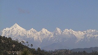
The Panchachuli (पंचाचुली) peaks are a group of five snow-capped Himalayan peaks lying at the end of the eastern Kumaon region, near Dugtu Village Darma valley. The peaks have altitudes ranging from 6,334 metres (20,781 ft) to 6,904 metres (22,651 ft). They form the watershed between the Gori and the Darmaganga valleys. Panchchuli is also located on the Gori Ganga-Lassar Yankti divide. The group lies 138 km (86 mi) from Pithoragarh. The first ascent of this range was done by Indo-Tibet Border Police (ITBP) team in 1972, via Uttari Balati glacier, led by Hukam Singh.
Namik Glacier is situated in the Pithoragarh district of Uttarakhand state in India.

Pindari Kanda Traill's Pass is a mountain pass through the Himalayas located between Nanda Devi and Nanda Kot peaks in the Uttarakhand state in the districts of Pithoragarh and Bageshwar in India.
Darma valley is a Himalayan valley situated in the Pithoragarh District of Uttarakhand state of India. This valley is located in the eastern part of Uttarakhand at Kumaon division.
Nagalaphu is a Himalayan mountain peak located in the Pithoragarh district of Uttarakhand state in India.
Sona Glacier is the Himalayan glacier situated in the eastern part of Uttarakhand in the Pithoragarh district of India.

Panchchuli Glacier is a Himalayan glacier, situated in the Pithoragarh district of Uttarakhand, India.
Gori Ganga is a river in the Munsiari tehsil of the Pithoragarh District, part of the state of Uttarakhand in northern India. Its principal source is the Milam Glacier, just northeast of Nanda Devi along with the Glaciers of the Ralam River, and the Pyunshani and Uttari & Dakshini Balati Glaciers that lie on the western face of the Panchachuli Peaks.
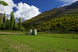
The Hopar Valley is a scenic portion of the Nagar Valley in Gilgit-Baltistan, in Pakistan. It is about 10 km away from Nagar Khas, the principal city of the Nagar Valley. Hopar Valley is home of the Spantik and Hopar (Hopper) glaciers.

The Hispar Valley or Hispar is the last Valley of Nagar Valley in the Gilgit-Baltistan region of Pakistan. The valley is located two kilometers below the snout of the 49 kilometer-long Hispar Glacier. It is about 28 km away from Nagar Khas and 25 km away from Hoper Valley. It can be reached from the Karakoram Highway by the road that leads towards Nagar and Hopar Valley. The Hispar valley links the Nagar District to the Shigar District via Hispar Pass at the altitude of 16,824 ft.

The Satopanth glacier is situated in the Indian state of Uttarakhand. River Alaknanda has it origin in Satopanth glacier. The glacier is one of the tourists favorite glaciers of Uttarakhand. Mountaineers consider it somewhat challenging to scale.
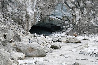
Gomukh, also known as "Gaumukh" or "Gomukhi", is the terminus or pout of the Gangotri Glacier and the source of the Bhagirathi River, one of the primary headstreams of the Ganga River. The word Gomukh/Gaumukh literally means "Mouth of a Cow."

Kolahoi Peak is a mountain with a peak elevation of 17,799 ft located in Anantnag district, Jammu and Kashmir, India. The mountain is the highest mountain in Kashmir Division. Kolahoi Peak is easily accessible through Aru valley and lies in the vicinity of Sonamarg in Ganderbal district. Kolahoi Peak is part of the Great Himalayan range, and is located 21 km north of Aru near Pahalgam. To its north flows the Sind River, while the Lidder River originates from the glacier located on the mountain and flows south.

Vasuki Parbat or Vasuki Parvat is a mountain range of Garhwal Himalaya in Vasuki Glacier Uttarakhand, India, It has a subsidiary peak Vasuki south. Vasuki Parbat standing majestically at 6792 meter and the south peak 6702 meter. Its the 35th highest located entirely within the uttrakhand India. Nanda Devi, is the highest mountain in this category.


