The Godavari is India's second longest river after the Ganga river and drains into the third largest basin in India, covering about 10% of India's total geographical area. Its source is in Trimbakeshwar, Nashik, Maharashtra. It flows east for 1,465 kilometres (910 mi), draining the states of Maharashtra (48.6%), Telangana (18.8%), Andhra Pradesh (4.5%), Chhattisgarh (10.9%) and Odisha (5.7%). The river ultimately empties into the Bay of Bengal through an extensive network of tributaries. Measuring up to 312,812 km2 (120,777 sq mi), it forms one of the largest river basins in the Indian subcontinent, with only the Ganga and Indus rivers having a larger drainage basin. In terms of length, catchment area and discharge, the Godavari is the largest in peninsular India, and had been dubbed as the Dakshina Ganga.

The Aravalli Range is a mountain range in Northern-Western India, running approximately 670 km (420 mi) in a south-west direction, starting near Delhi, passing through southern Haryana, Rajasthan, and ending in Ahmedabad Gujarat. The highest peak is Guru Shikhar on Mount Abu at 1,722 m (5,650 ft). The Aravalli Range is arguably the oldest geological feature on Earth, having its origin in the Proterozoic era.

The Ōpāwaho / Heathcote River lies within the city boundaries of Christchurch, New Zealand, and is fed from springs near Templeton Road, with a catchment area in wet weather extending as far west as Yaldhurst and Pound Road. It meanders around the base of the Port Hills from west to south-east.

Teesta River is a 414 km (257 mi) long river that rises in the Pauhunri Mountain of eastern Himalayas, flows through the Indian states of Sikkim and West Bengal and subsequently enters Bangladesh through Rangpur division. In Bangladesh, it falls into Brahmaputra River which after meeting some other major rivers of Bengal delta finally falls into the Bay of Bengal. It drains an area of 12,540 km2 (4,840 sq mi). In India, it flows through Mangan District, Gangtok District, Pakyong District, Kalimpong district, Darjeeling District, Jalpaiguri District, Cooch Behar districts and the cities of Rangpo, Jalpaiguri and Mekhliganj. In Bangladesh, it flows through Lalmonirhat District, Rangpur District, Kurigram District and Gaibandha District. It joins the Brahmaputra River at Phulchhari Upazila in Bangladesh. 305 km (190 mi) of the river lies in India and 109 km (68 mi) in Bangladesh. Teesta is the largest river of Sikkim and second largest river of West Bengal after the Ganges.

The Ghaghara River, called Karnali River in Nepal, Mapcha Tsangpo in Tibet, and the lower Ghaghara in Awadh called Sarayu River, is a perennial trans-boundary river that originates in the northern slopes of the Himalayas in the Tibetan Plateau, cuts through the Himalayas in Nepal and joins the Sharda River at Brahmaghat in India. Together they form the Ghaghara River, a major left bank tributary of the Ganges. With a length of 507 km (315 mi) it is the longest river in Nepal. The total length of Ghaghara River up to its confluence with the Ganges at Revelganj in Bihar is 1,080 km (670 mi). It is the largest tributary of the Ganges by volume and the second largest by length after Yamuna.

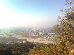
Haldwani is the largest city of Kumaon. It is also the third most populous city and largest commercial market in the Indian state of Uttarakhand. Haldwani is said to be the financial capital of Uttarakhand, having the most commercial, economic and industrial activities of the state. Haldwani is located in the Nainital District, and is one of its eight Subdivisions. The Haldwani Urban agglomeration has 232,060 people as of 2011, and is the third most populous UA in Uttarakhand, after Dehradun and Haridwar. Being situated in the immediate foothills of Kumaon Himalayas, the Kathgodam neighbourhood of Haldwani is known as the "Gateway to Kumaon".

The Chambal River is a tributary of the Yamuna River in Central and Northern India, and thus forms part of the drainage system of the Ganges. The river flows north-northeast through Madhya Pradesh, running for a time through Rajasthan then forming the boundary between Rajasthan and Madhya Pradesh before turning southeast to join the Yamuna in Uttar Pradesh state.

The Subarnarekha River flows through the Indian states of Jharkhand, West Bengal and Odisha.

Shahjahanpur district is a districts of Uttar Pradesh India. It is a part of Bareilly division. It was established in 1813 by the British Government. Previously it was a part of district Bareilly. Geographically the main town is Shahjahanpur which is its headquarters. Its 4 Tehsils are: Powayan, Tilhar, Jalalabad and Sadar.

The Kosi or Koshi is a transboundary river which flows through China, Nepal and India. It drains the northern slopes of the Himalayas in Tibet and the southern slopes in Nepal. From a major confluence of tributaries north of the Chatra Gorge onwards, the Kosi River is also known as Saptakoshi for its seven upper tributaries. These include the Tamur River originating from the Kanchenjunga area in the east and Arun River and Sun Kosi from Tibet. The Sun Koshi's tributaries from east to west are Dudh Koshi, Likhu Khola, Tamakoshi River, Bhote Koshi, and Indravati. The Saptakoshi crosses into northern Bihar, India where it branches into distributaries before joining the Ganges near Kursela in Katihar district.
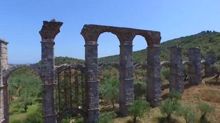
The Romans constructed aqueducts throughout their Republic and later Empire, to bring water from outside sources into cities and towns. Aqueduct water supplied public baths, latrines, fountains, and private households; it also supported mining operations, milling, farms, and gardens.

Sitarganj is a city and a municipal board in Udham Singh Nagar district in the Indian state of Uttarakhand. Now it is home to the Integrated Industrial Estate Sitarganj (IIE) being developed by State Industrial Development Corporation of Uttarakhand Limited (SIDCUL).
Ramganga is a tributary of the river Ganges, originating in Uttarakhand state, India.
Badkhal Lake was a natural lake situated in Badkhal village near Faridabad, in the Indian state of Haryana, about 32 kilometers from the national capital of Delhi. Fringed by the hills of the Aravalli Range, this was a man-made embankment. Owing to unchecked mining in neighbouring areas, the lake began drying up two decades back and is now totally dried up. There are functional Haryana Tourism Corporation restaurants in the vicinity. A flower show is held every spring here. Its name is most probably derived from the Persian word beydakhal, which means free from interference. Close to Badkhal Lake is the Peacock Lake. It is a biodiversity area within the Northern Aravalli leopard wildlife corridor stretching from Sariska Tiger Reserve to Delhi.

Stream restoration or river restoration, also sometimes referred to as river reclamation, is work conducted to improve the environmental health of a river or stream, in support of biodiversity, recreation, flood management and/or landscape development.

A stream is a continuous, flowing body of surface water within the bed and banks of a channel. Depending on its location or certain characteristics, a stream may be referred to by a variety of local or regional names. Long, large streams are usually called rivers, while smaller, less voluminous and more intermittent streams are known as streamlets, brooks or creeks.

The Sharda River, also called Kali River and Mahakali River, originates at Kalapani in the Himalayas at an elevation of 3,600 m (11,800 ft) in the Pithoragarh district in Uttarakhand, India. It flows along Nepal's western border with India and has a basin area of 14,871 km2 (5,742 sq mi). It joins Ghaghra River, a tributary of the Ganges. It takes the name Kali River from the union of the two streams at Gunji as it flows through the hills. After Brahmadev Mandi near Tanakpur, it enters the Terai plains, where it is called Sharda River.
The Malewa River rises in the western slopes of the Aberdare Range in Kenya and flows south and west into Lake Naivasha in the Great Rift Valley. Lake Naivasha is an important source of water in a semi-arid environment, and supports export-oriented horticulture and floriculture businesses as well as tourism. Malewa River water quality has deteriorated because of more human activities in the upper catchment. Long-term effects of this on the percentage of rainfall getting into Lake Naivasha are not clear. Possibly in low-rainfall years the percentage will drop because of water abstraction, while in high-rainfall years the percentage will go up because of cultivated soils having a lower water-holding capacity and the introduction of more 100% runoff surfaces like tarmac roads and iron sheets, etc.

The Sahibi river, also called the Sabi River, is an ephemeral, rain-fed river flowing through Rajasthan, Haryana and Delhi states in India. It drains into Yamuna in Delhi, where its channeled course is also called the Najafgarh drain, which also serves as Najafgarh drain bird sanctuary. Sahibi is a seasonal river which is 300 km long and flows from Aravalli hills in Rajasthan to Haryana, of which 100 km is in Haryana.
Legacy sediment (LS) is depositional bodies of sediment inherited from the increase of human activities since the Neolithic. These include a broad range of land use and land cover changes, such as agricultural clearance, lumbering and clearance of native vegetation, mining, road building, urbanization, as well as alterations brought to river systems in the form of dams and other engineering structures meant to control and regulate natural fluvial processes (erosion, deposition, lateral migration, meandering). The concept of LS is used in geomorphology, ecology, as well as in water quality and toxicological studies.