Related Research Articles

The Ganges is a trans-boundary river of Asia which flows through India and Bangladesh. The 2,525 km (1,569 mi) river rises in the western Himalayas in the Indian state of Uttarakhand. It flows south and east through the Gangetic plain of North India, receiving the right-bank tributary, the Yamuna, which also rises in the western Indian Himalayas, and several left-bank tributaries from Nepal that account for the bulk of its flow. In West Bengal state, India, a feeder canal taking off from its right bank diverts 50% of its flow southwards, artificially connecting it to the Hooghly river. The Ganges continues into Bangladesh, its name changing to the Padma. It is then joined by the Jamuna, the lower stream of the Brahmaputra, and eventually the Meghna, forming the major estuary of the Ganges Delta, and emptying into the Bay of Bengal. The Ganges-Brahmaputra-Meghna system is the second largest river on earth by discharge.
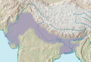
The Indo-Gangetic Plain, also known as the North Indian River Plain, is a 700-thousand km2 (172-million-acre) fertile plain encompassing northern regions of the Indian subcontinent, including most of northern and eastern India, most of eastern-Pakistan, virtually all of Bangladesh and southern plains of Nepal. The region is named after the Indus and the Ganges rivers and encompasses a number of large urban areas. The plain is bound on the north by the Himalayas, which feed its numerous rivers and are the source of the fertile alluvium deposited across the region by the two river systems. The southern edge of the plain is marked by the Deccan Plateau. On the west rises the Iranian Plateau. Many developed cities like Delhi, Dhaka, Kolkata, Lahore and Karachi are located in the Indo-Gangetic Plain.

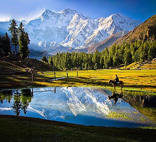
Valley of Flowers National Park is an Indian national park which was established in 1982. It is located in Chamoli in the state of Uttarakhand and is known for its meadows of endemic alpine flowers and the variety of flora. This richly diverse area is also home to rare and endangered animals, including the Asiatic black bear, snow leopard, musk deer, brown bear, red fox and blue sheep. Birds found in the park include Himalayan monal pheasant and other high altitude birds.
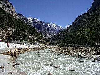
The Bhāgīrathī is a turbulent Himalayan river in the Indian state of Uttarakhand, and one of the two headstreams of the Ganges, the major river of Northern India and the holy river of Hinduism. In the Hindu faith, mythology, and culture, the Bhagirathi is considered the source stream of the Ganges. However, in hydrology, the other headstream, Alaknanda, is considered the source stream on account of its great length and discharge. The Bhagirathi and Alaknanda join at Devprayag in Garhwal and are thereafter known as the Ganges.

Chamoli district is a district of the Uttarakhand state of India. It is bounded by the Tibet region to the north, and by the Uttarakhand districts of Pithoragarh and Bageshwar to the east, Almora to the south, Pauri Garhwal to the southwest, Rudraprayag to the west, and Uttarkashi to the northwest. The administrative headquarters of Chamoli district is in Gopeshwar.

The Alaknanda is a Himalayan river in the Indian state of Uttarakhand and one of the two headstreams of the Ganges, the major river of Northern India and the holy river of Hinduism. In hydrology, the Alaknanda is considered the source stream of the Ganges on account of its greater length and discharge; however, in Hindu tradition and culture, the other headstream, the Bhagirathi, is considered the source stream.
The Chota Char Dham, is an important Hindu pilgrimage circuit in Uttarakhand, in the Indian Himalayas. Located in the Garhwal region of the state of Uttarakhand, the circuit consists of four sites—Yamunotri, Gangotri, Kedarnath, and Badrinath. Badrinath is also one of the four destinations of the longer Char Dham from which the Chota Char Dham likely draws its name.
Darma valley is a Himalayan valley situated in the Pithoragarh District of Uttarakhand state of India. This valley is located in the eastern part of Uttarakhand at Kumaon division.

The Neelum River, or Kishanganga River, is a river in the Kashmir region of India and Pakistan. It originates in Bandipora district of northern Jammu and Kashmir in India, flows through the Neelam Valley in Pakistan's Azad Kashmir, where parts of its course fall along the Line of Control, before merging with the Jhelum River near the city of Muzaffarabad.
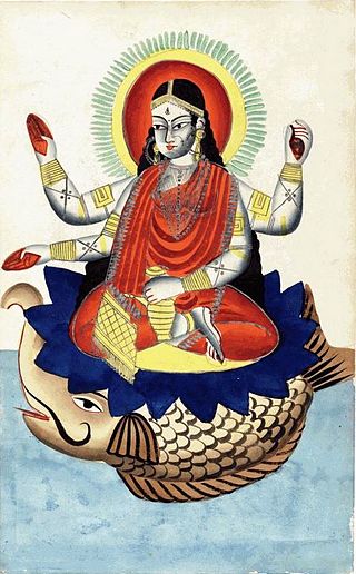
Ganga is the personification of the river Ganges, who is worshipped by Hindus as the goddess of purification and forgiveness. Known by many names, Ganga is often depicted as a fair, beautiful woman, riding a divine crocodile-like creature called the makara. Some of the earliest mentions of Ganga are found in the Rigveda, where she is mentioned as the holiest of the rivers. Her stories mainly appear in post-Vedic texts such as the Ramayana, Mahabharata, and the Puranas.
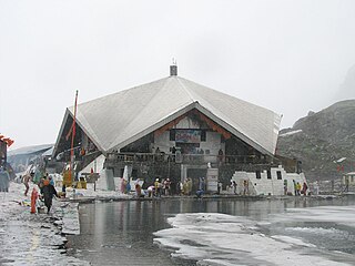
Hemkund Sahib, formally known as Gurudwara Shri Hemkund Sahib Ji, is a Sikh place of worship and pilgrimage site in Chamoli district, Uttarakhand, India. It is devoted to Guru Gobind Singh (1666–1708), the tenth Sikh Guru, and finds mention in Dasam Granth. With its setting of a glacial lake surrounded by seven mountain peaks, each adorned by a Nishan Sahib on its cliff, it is according to the Survey of India located in the Garhwal Himalaya at an elevation of 4,160 meters. It is approached from Govindghat on the Rishikesh-Badrinath highway. The main town near Gobindghat is Joshimath. The elevation of the lake at Hemkund is approximately 13,650 feet.

Ghangaria is a small village on the way to Hemkund Sahib, a popular pilgrimage site for Sikhs which is about 6 km from here and the Valley of Flowers, a national park known for its variety of flowers about 5 km from here. It is located in the northern Himalayan ranges at an altitude of 3049 meters in Uttarakhand state of India.

Gori Ganga is a river in the Munsiari tehsil of the Pithoragarh District, part of the state of Uttarakhand in northern India. Its principal source is the Milam Glacier, just northeast of Nanda Devi along with the Glaciers of the Ralam River, and the Pyunshani and Uttari & Dakshini Balati Glaciers that lie on the western face of the Panchachuli Peaks.

Govindghat is a town in Chamoli district, Uttarakhand, India, located at the confluence of the Alaknanda and Lakshman Ganga rivers. It lies around roughly 22 kilometres (14 mi) from Joshimath on NH58 at an altitude of 6,000 feet. It is the roadhead on the way to Shree Badrinathji yatra - One of the important places of worship of Hindus and the starting point for trekking to Hemkund Sahib and Valley of Flowers. Hundreds of people, mostly Hindu pilgrims to Shree Badrinathji and Sikh pilgrims on way to the holy shrine of Shree Hemkund Sahibji and occasional tourists to the Valley of Flowers, arrive here every day.
Pusweli Oya is a major tributary of Kelani Ganga river in Sri Lanka.
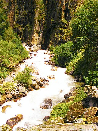
Pushpawati River flows through the Valley of Flowers in Chamoli district in Garhwal region of the Indian state of Uttarakhand.

Jadh Ganga, also called the Jahnavi River, is a tributary of the Bhagirathi River in the Uttarakhand state of India.
Nelang or Nilang is a river valley of the Himalayas, containing a small eponymous village, in the Uttarkashi District of the state of Uttarakhand, India. It is close to the disputed Sino-Indian Line of Actual Control (LAC), and hence is also claimed by China as part of Zanda County of Ngari Prefecture of Tibet.
The Western Himalayas refers to the western half of the Himalayas, in northern Pakistan and northwestern India. It is also known as the Punjab Himalayas. Four of the five tributaries of the Indus River in Punjab rise in the Western Himalayas; while the fifth, the Sutlej cuts through the range after rising in Tibet.

Nilgiri Parbat is a mountain of the Garhwal Himalaya in Uttarakhand India and rises to an elevation of 6,474 metres (21,240 ft) with a prominence is 893 metres (2,930 ft). It is 91st highest located entirely within Uttarakhand. Nanda Devi, is the highest mountain in this category. It lies 6.7 km NW of Ratabon and 9.4 km south of Deoban. It lies 6.3 km SSW of Mandir Parbat its nearest higher neighbor. It is located 12.7 km NNW of Hathi Parbat 6,727 metres (22,070 ft) and 11.2 km north lies Mana Peak 7,272 metres (23,858 ft).
References
- ↑ "Hemkund Sahib". www.gmvnl.com. Archived from the original on 28 May 2006.